Storfjord
| Storfjord kommune Omasvuona suohkan (Northern Sami) Omasvuonon kunta (Kven) | |||
|---|---|---|---|
| Municipality | |||
 View of the Skibotn harbor and camping area | |||
| |||
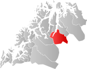 Storfjord within Troms | |||
| Coordinates: 69°16′43″N 20°17′12″E / 69.27861°N 20.28667°ECoordinates: 69°16′43″N 20°17′12″E / 69.27861°N 20.28667°E | |||
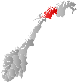
| Country | Norway | ||
| County | Troms | ||
| District | Nord-Troms | ||
| Established | 1929 | ||
| Administrative centre | Hatteng | ||
| Government | |||
| • Mayor (2015) | Knut Jentoft (Local list) | ||
| Area | |||
| • Total | 1,542.83 km2 (595.69 sq mi) | ||
| • Land | 1,477.85 km2 (570.60 sq mi) | ||
| • Water | 64.98 km2 (25.09 sq mi) 4.2% | ||
| Area rank | #49 in Norway | ||
| Population (2017) | |||
| • Total | 1,890 | ||
| • Rank | #333 in Norway | ||
| • Density | 1.3/km2 (3/sq mi) | ||
| • Change (10 years) | -1.1% | ||
| Demonym(s) | Storfjording[1] | ||
| Time zone | UTC+01:00 (CET) | ||
| • Summer (DST) | UTC+02:00 (CEST) | ||
| ISO 3166 code | NO-1939 | ||
| Official language form | Neutral | ||
| Website |
storfjord | ||

Storfjord (Norwegian), Omasvuotna (Northern Sami), or Omasvuono (Kven)[2] is a municipality in Troms county, Norway. The administrative centre of the municipality is the village of Hatteng. Other villages in Storfjord include Elvevoll, Oteren, and Skibotn.
The 1,543-square-kilometre (596 sq mi) municipality is the 49th largest by area out of the 422 municipalities in Norway. Storfjord is the 333rd most populous municipality in Norway with a population of 1,890. The municipality's population density is 1.3 inhabitants per square kilometre (3.4/sq mi) and its population has decreased by 1.1% over the last decade.[3]
General information
The municipality of Storfjord was established in 1929 when the large Lyngen Municipality was divided into three: Lyngen Municipality in the northwest, Kåfjord Municipality in the northeast, and Storfjord Municipality in the south. The initial population of Storfjord was 1,499. On 1 January 1964, the Elvebakken farm of Balsfjord Municipality was transferred to Storfjord. Then on 1 January 1992, one uninhabited farm in the Nordnes area of Lyngen Municipality was transferred to Storfjord.[4]
Name
The municipality is named after the Storfjorden. The first element is stor which means "great" or "big", so it basically means "great fjord". After a long debate within the municipality, in 2014 the municipality (and national government) approved co-official names of the municipality in the Northern Sami language and Kven language. Omasvuotna (Northern Sami) or Omasvuono (Kven) are parallel, co-equal names that can be used interchangeably to refer to the municipality in the three different languages.[5]
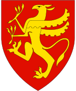
Coat of arms
The coat of arms is from modern times; it was granted on 9 February 1990. The arms show three poppies of the very rare species Papaver laestadianum (a subspecies of Papaver radicatum). The poppies are rotated around a meeting point which represents the meeting point (Treriksrøysa) of the three countries Norway, Sweden, and Finland, that lies on the edge of the municipality.[6][7]
Churches
The Church of Norway has one parish (sokn) within the municipality of Storfjord. It is part of the Nord-Troms prosti (deanery) in the Diocese of Nord-Hålogaland.
| Parish (Sokn) | Church Name | Location of the Church | Year Built |
|---|---|---|---|
| Storfjord | Storfjord Church | Hatteng | 1952 |
| Skibotn Chapel | Skibotn | 1895 |
History

The Sami culture is the original culture; however, in the 19th century, settlers came from Finland and from the valleys of Southern Norway to establish themselves. Sami culture, though, has survived in parts of Storfjord to the present. In the 19th century, Laestadianism, a puritan religious movement, obtained a strong position. Skibotn is even today a stronghold for this movement.
The market of Skibotn was traditionally a meeting point between ethnic groups, where Sami, Finns, and Norwegians met to trade. This market still takes place today. The ethnic mix is interesting, with both Sami and Finnish cultures represented. In the valley of Signaldalen, a Norwegian dialect of southern origin is spoken, a relic of the valley's settlement from the south in the early 19th century.
World War Two
There were several prison camps there during World War Two.[8] A 2014 NRK article estimated that a total of around 7000 or 8000 Soviet prisoners, were interred in these prison camps.[8] Furthermore, the Mallnitz Camp was the worst.[8]
Government
All municipalities in Norway, including Storfjord, are responsible for primary education (through 10th grade), outpatient health services, senior citizen services, unemployment and other social services, zoning, economic development, and municipal roads. The municipality is governed by a municipal council of elected representatives, which in turn elect a mayor.[9] The municipality falls under the Nord-Troms District Court and the Hålogaland Court of Appeal.
Municipal council
The municipal council (Kommunestyre) of Storfjord is made up of 17 representatives that are elected to four year terms. Currently, the party breakdown is as follows:[10]
| Party Name | Name in Norwegian | Number of representatives | |
|---|---|---|---|
| Labour Party | Arbeiderpartiet | 3 | |
| Progress Party | Fremskrittspartiet | 1 | |
| Conservative Party | Høyre | 4 | |
| Green Party | Miljøpartiet De Grønne | 1 | |
| Centre Party | Senterpartiet | 2 | |
| Local Lists | Lokale lister | 6 | |
| Total number of members: | 17 | ||
Geography
The municipality is situated around the inner parts of the Lyngen fjord. Storfjord borders both Finland and Sweden, and the borders of the three countries meet at the beacon of Treriksröset, the northernmost point of Sweden. Treriksrøysa is a popular hiking destination; there are no fences, so at this location one step forward is all that is needed to get from one country to another. Pine and birch forests are common in the valleys in Storfjord, and the more rare calcareous pine forests, with several orchids, are also present. The lake Rihpojávri is located near the eastern border of Storfjord.
Climate
The Skibotn valley has a microclimate with very little clouds by Norwegian standards, and annual precipitation down to 300 to 450 millimetres (12 to 18 in). The monthly 24-hr average temperature varies from −6.5 °C (20.3 °F) in January to 13.5 °C (56.3 °F) in July.[11]
| Climate data for Skibotn | |||||||||||||
|---|---|---|---|---|---|---|---|---|---|---|---|---|---|
| Month | Jan | Feb | Mar | Apr | May | Jun | Jul | Aug | Sep | Oct | Nov | Dec | Year |
| Daily mean °C (°F) | −6.5 (20.3) |
−6.1 (21) |
−3.5 (25.7) |
1.1 (34) |
6.4 (43.5) |
10.9 (51.6) |
13.5 (56.3) |
11.9 (53.4) |
7.1 (44.8) |
2.6 (36.7) |
−2.3 (27.9) |
−5.4 (22.3) |
2.5 (36.5) |
| Average precipitation mm (inches) | 43 (1.69) |
42 (1.65) |
30 (1.18) |
24 (0.94) |
20 (0.79) |
34 (1.34) |
46 (1.81) |
48 (1.89) |
41 (1.61) |
54 (2.13) |
47 (1.85) |
46 (1.81) |
475 (18.7) |
| Source: Norwegian Meteorological Institute[12] | |||||||||||||
References
- ↑ "Navn på steder og personer: Innbyggjarnamn" (in Norwegian). Språkrådet. Retrieved 2015-12-01.
- ↑ "Stadnamn og rettskriving" (in Norwegian). Kartverket. Retrieved 2018-07-13.
- ↑ Statistisk sentralbyrå (2017). "Table: 06913: Population 1 January and population changes during the calendar year (M)" (in Norwegian). Retrieved 2017-09-09.
- ↑ Jukvam, Dag (1999). "Historisk oversikt over endringer i kommune- og fylkesinndelingen" (PDF) (in Norwegian). Statistisk sentralbyrå.
- ↑ Pulk, Åse (2014-03-07). "Storfjord kommune er Omasvuona suohkan på samisk". NRK Sapmi (in Norwegian). Retrieved 2018-08-06.
- ↑ "Storfjord kommunes våpen" (in Norwegian). Retrieved 2008-12-07.
- ↑ "Civic heraldry of Norway - Norske Kommunevåpen". Heraldry of the World. Retrieved 2018-08-06.
- 1 2 3 Bare 35 av 272 krigsfanger overlevde dødsleiren [Only 35 of 272 war prisoners survived the death camp]
- ↑ Hansen, Tore, ed. (2016-05-12). "kommunestyre". Store norske leksikon (in Norwegian). Kunnskapsforlaget. Retrieved 2018-08-06.
- ↑ "Table: 04813: Members of the local councils, by party/electoral list at the Municipal Council election (M)" (in Norwegian). Statistics Norway.
- ↑ Skibotn in Storfjord 1961-90 climate averages Archived 2012-05-26 at Archive.is
- ↑ "eKlima Web Portal". Norwegian Meteorological Institute. Archived from the original on 2004-06-14.
External links
| Wikimedia Commons has media related to Storfjord. |
| Look up storfjord in Wiktionary, the free dictionary. |
| Wikivoyage has a travel guide for Troms. |
- Municipal fact sheet from Statistics Norway (in Norwegian)
| |||||||||
| |||||||||
| |||||||||
| Authority control |
|---|