Stopče
| Stopče | |
|---|---|
 | |
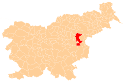
 Stopče Location in Slovenia | |
| Coordinates: 46°12′55.49″N 15°25′27.66″E / 46.2154139°N 15.4243500°ECoordinates: 46°12′55.49″N 15°25′27.66″E / 46.2154139°N 15.4243500°E | |
| Country |
|
| Traditional region | Styria |
| Statistical region | Savinja |
| Municipality | Šentjur |
| Area | |
| • Total | 0.99 km2 (0.38 sq mi) |
| Elevation | 272.8 m (895.0 ft) |
| Population (2002) | |
| • Total | 255 |
| [1] | |
Stopče (pronounced [ˈstoːptʃɛ]) is a village in the Municipality of Šentjur in eastern Slovenia. It lies on the regional road leading east from Šentjur to Grobelno. The area is part of the historical Styria region. The municipality is now included in the Savinja Statistical Region.[2]
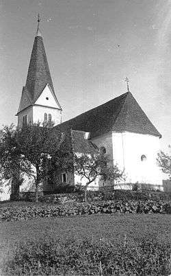
The local church is dedicated to Saint Acacius (Slovene: sveti Ahac) and belongs to the Parish of Šentjur. It dates to 17th century and was extended and vaulted in 1777.[3]
References
- ↑ Statistical Office of the Republic of Slovenia
- ↑ Šentjur municipal site Archived 2011-01-15 at the Wayback Machine.
- ↑ Slovenian Ministry of Culture register of national heritage reference number ešd 3042
External links
- Stopče at Geopedia

This article is issued from
Wikipedia.
The text is licensed under Creative Commons - Attribution - Sharealike.
Additional terms may apply for the media files.