Cerovec, Šentjur
| Cerovec | |
|---|---|
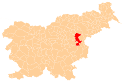
 Cerovec Location in Slovenia | |
| Coordinates: 46°15′5.19″N 15°21′39.41″E / 46.2514417°N 15.3609472°ECoordinates: 46°15′5.19″N 15°21′39.41″E / 46.2514417°N 15.3609472°E | |
| Country |
|
| Traditional region | Styria |
| Statistical region | Savinja |
| Municipality | Šentjur |
| Area | |
| • Total | 4.09 km2 (1.58 sq mi) |
| Elevation | 296.8 m (973.8 ft) |
| Population (2002) | |
| • Total | 143 |
| [1] | |
Cerovec (pronounced [ˈtseːɾɔʋəts]) is a settlement in the Municipality of Šentjur in eastern Slovenia. It lies 10 km east of Celje and the A1 motorway crosses the settlement's territory. The area is part of the historical region of Styria. The municipality is now included in the Savinja Statistical Region.[2]
A hidden underground structure in the Šohta Woods near the settlement, built in 1944, was used as a secret Partisan hospital (Slovene: partizanska bolnišnica Zima).[3]
References
- ↑ Statistical Office of the Republic of Slovenia
- ↑ Šentjur municipal site Archived 2011-01-15 at the Wayback Machine.
- ↑ Slovenian Ministry of Culture register of national heritage reference number ešd 15615
External links
This article is issued from
Wikipedia.
The text is licensed under Creative Commons - Attribution - Sharealike.
Additional terms may apply for the media files.