Texas State Highway 35
| |||||||
|---|---|---|---|---|---|---|---|
 | |||||||
| Route information | |||||||
| Maintained by TxDOT | |||||||
| Length | 206.5 mi[1] (332.3 km) | ||||||
| Existed | 1917–present | ||||||
| Major junctions | |||||||
| West end |
| ||||||
| in Houston | |||||||
| East end |
| ||||||
| Highway system | |||||||
| |||||||

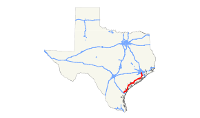
State Highway 35, or SH 35, is a largely north–south highway in southeastern and southern Texas between Houston, junction of I-45 on the southeast side of the city and Corpus Christi, where it terminates at I-37.
SH 35 takes a generally north–south route from Houston to Angleton, junction SH 288, and then roughly parallels the inlets of the Gulf of Mexico in a roughly northeast-southwest course through a low, flat coastal plain. To the south and west of Palacios it gives vistas of several inlets of the Gulf of Mexico, becoming one of the more scenic routes of southern Texas.
At Gregory it meets and joins U.S. Highway 181, which coincide to their mutual terminus over Nueces Bay causeway and bridge over Corpus Christi Bay, meeting I-37 and SH 286 at a freeway interchange.
Only in its southernmost part near Corpus Christi is State Highway 35 a freeway, although significant stretches of it are divided highway. It is not to be confused with Interstate 35, which it never meets. It is not the shortest or quickest route between Houston and Corpus Christi, which consists largely of US 59 and US 77.
Route description
SH 35 begins at an interchange with Interstate 37 near downtown Corpus Christi concurrent with US 181. The two highways run as a freeway near Corpus Christi Bay before crossing Nueces Bay into the town of Portland. In Portland, US 181 leaves SH 35, traveling towards Sinton. Just outside Gregory, the freeway segment of SH 35 ends. After crossing FM 136, SH 35 begins to run in an east-west direction to Aransas Pass, before turning towards the northeast. In the town of Rockport, SH 35 runs as a divided expressway before returning to its business loop. The highway passes by the Aransas National Wildlife Refuge before entering into Refugio County.
Future of SH 35
Spur 5

In Houston, SH 35 is Telephone Road and Reveille Street from its northern terminus at Interstate 45. An upgrade of the facility (in a slightly different corridor) to freeway standards is planned, tentatively named the Alvin Freeway. As of 2006, only 1.3 miles (approximately 2 km) had been built, under the sign Spur 5 (constructed between 1996–99; officially opened September 1999; designated 1998). However, the mainlanes extend less than half a mile south of Interstate 45 adjacent to the campus of the University of Houston.
Loop 5

The number was previously used for Loop 5, which was designated on September 26, 1939 from US 81 through Kyle to US 81 as a renumbering of SH 2 Loop.[2] On September 28, 1950, the section along Burleson St was cancelled and the rest along Center St became Spur 5. On October 27, 1952, Spur 5 was cancelled and transferred to FM 150 (now RM 150). On June 30, 1958, another route, also called Spur 5, was designated from FM 1406 and SH 124 to Interstate 10. On October 31, 1962, The section of the Spur 5 from FM 1406 to SH 73 became a rerouting of SH 124. On August 4, 1988, Spur 5 was cancelled and mileage was transferred to FM 1663. The current route was designated on October 29, 1998.
An overlap of Highway 35 with the Gulf Freeway was also constructed in the 1980s. This portion extends from Spur 5 to Dowling Street, a distance of about 1.6 miles (2.6 km). This section contains three elevated lanes in each direction (briefly four southbound lanes near the southern terminus). This overlap section is 22 lanes wide, including mainlanes, feeder roads, and a reversible HOV lane.[3]
Once built, the Alvin Freeway is planned to follow a corridor near Mykawa Road from the terminus to Beltway 8 before returning to its normal undivided state.
| Browse numbered routes | ||||
|---|---|---|---|---|
| ← | Loop 5 | Spur 5 | ||
History

SH 35 was originally proposed on November 19, 1917 as a route from Paris to Houston.[4] On August 21, 1923, the northern half of the highway had been renumbered as SH 49, with the new northern end now going east to the Louisiana border.[5] On November 14, 1927, it extended to Alvin.[6] On April 10, 1934, it had been extended southwest along cancelled SH 58 and SH 57, ending in Gregory.[7] On February 21, 1938, SH 35 Spur was designated to Danbury, as SH 35 was rerouted to bypass Danbury. On September 26, 1939, the section north of Houston was removed when it was renumbered as U.S. Highway 59. SH 35 Spur was renumbered as Spur 28. The section south of Gregory was transferred to US 181. On October 5, 1972, SH 35 extended back to Corpus Christi along US 181. On January 15, 1986, an Angleton bypass opened, with the old route becoming Loop 558. On February 25, 1987, SH 35 was rerouted back over Loop 558, and the bypass became Loop 558 instead (now FM 523). On April 27, 1995, another bypass opened, so that SH 35 no longer goes through Aransas Pass or Rockport. On March 29, 2007, an Old Ocean bypass opened, with the old route becoming Loop 419 (now Spur 419).

SH 35A was a proposed spur route off SH 35 designated on March 18, 1918, with a route splitting off at Livingston, and travelling west to New Waverly.[8] On September 17, 1918, a branch of SH 35 was designated from Livingston via Liberty and Devers to Anahuac.[9] By 1919, the section west of Livingston was redesignated as part of SH 45. By 1922, SH 35A was redesignated as a route from Livingston via Liberty and Devers to Anahuac, replacing this branch of SH 35. On August 21, 1923, it was renumbered as SH 61.[5] By 1926, the section of SH 61 north of Devers was cancelled. By 1928, the Livingston to Liberty section was renumbered as SH 132. By 1933, that became a portion of SH 146.
SH 35B was a spur of SH 35 from Jefferson to the Louisiana border.[10] On August 21, 1923, this was renumbered as SH 49.
Junction list
| County | Location | mi | km | Destinations | Notes |
|---|---|---|---|---|---|
| Nueces | Corpus Christi | I-37 exit 0 southbound; South end of US 181 overlap; continues south as Spur 544. | |||
| Belden Street | Southbound exit and northbound entrance | ||||
| Burleson Street, Causeway Boulevard | No northbound entrance | ||||
| Beach Avenue | No southbound entrance | ||||
| San Patricio | Portland | Nueces Bay | |||
| Frontage Road | Southbound exit and entrance | ||||
| Northbound exit and southbound entrance | |||||
| Frontage Road | No northbound entrance | ||||
| Frontage Road | Northbound exit only | ||||
| Gregory | North end of US 181 overlap; northbound exit and southbound entrance | ||||
| Southbound exit and northbound entrance | |||||
| No northbound entrance | |||||
| No northbound exit; north end of freeway | |||||
| | |||||
| | Interchange; northbound exit and southbound entrance | ||||
| Aransas Pass | Interchange; no northbound exit | ||||
| Aransas | | Interchange | |||
| Rockport | Interchange | ||||
| Interchange | |||||
| South end of FM 3036 overlap | |||||
| North end of FM 3036 overlap | |||||
| | |||||
| Lamar | |||||
| Refugio | | ||||
| | |||||
| | South end of SH 239 overlap | ||||
| Tivoli | North end of SH 239 overlap | ||||
| Calhoun | | South end of SH 185 overlap | |||
| | North end of SH 185 overlap | ||||
| | |||||
| | |||||
| | |||||
| | |||||
| Port Lavaca | |||||
| Point Comfort | |||||
| | |||||
| Jackson | | ||||
| | |||||
| | |||||
| Matagorda | Palacios | ||||
| | |||||
| | |||||
| Blessing | |||||
| Elmaton | |||||
| Markham | South end of FM 1468 overlap | ||||
| North end of FM 1468 overlap | |||||
| | Colorado River Turnaround | Interchange | |||
| Bay City | |||||
| Van Vleck | |||||
| | |||||
| Brazoria | | ||||
| Old Ocean | South end of FM 524 overlap | ||||
| | |||||
| | North end of FM 524 overlap | ||||
| | |||||
| | |||||
| West Columbia | |||||
| Bailey's Prairie | South end of FM 521 overlap | ||||
| North end of FM 521 overlap | |||||
| Angleton | |||||
| | |||||
| | |||||
| Alvin | |||||
| Interchange | |||||
| Interchange | |||||
| | |||||
| Pearland | |||||
| Harris | Houston | ||||
| I-610 exit 32B; interchange; northbound entrance from IH 45 closed until April 2018 | |||||
| I-45 exit 40 southbound; interchange; southbound exit and northbound entrance | |||||
1.000 mi = 1.609 km; 1.000 km = 0.621 mi
| |||||
See also
References
- ↑ Transportation Planning and Programming Division (n.d.). "State Highway No. 35". Highway Designation Files. Texas Department of Transportation. Retrieved January 30, 2016.
- ↑ Transportation Planning and Programming Division (n.d.). "State Highway Spur No. 5". Highway Designation Files. Texas Department of Transportation. Retrieved January 30, 2016.
- ↑ Chapter 4, The Spokes Archived 2006-09-04 at the Wayback Machine., p. 163 Houston Freeways, Erik Slotboom.
- ↑ "Minutes from 6th State Highway Commission meeting" (PDF). November 19, 1917.
- 1 2 "Minutes from 73rd State Highway Commission meeting" (PDF). August 21, 1923.
- ↑ (PDF) https://publicdocs.txdot.gov/minord/MinuteOrderDocLib/003676984.pdf. Missing or empty
|title=(help) - ↑ (PDF) https://publicdocs.txdot.gov/minord/MinuteOrderDocLib/003673847.pdf. Missing or empty
|title=(help) - ↑ "Minutes from 10th State Highway Commission meeting" (PDF). March 18, 1918.
- ↑ "Minutes from 16th State Highway Commission meeting" (PDF). September 17, 1918.
- ↑ "Minutes from 70th State Highway Commission meeting" (PDF). May 21, 1923.
External links
![]()