Tivoli, Texas
| Tivoli, Texas | |
|---|---|
| Unincorporated community / Census-designated place (CDP) | |
| Coordinates: 28°27′39″N 96°53′29″W / 28.46083°N 96.89139°WCoordinates: 28°27′39″N 96°53′29″W / 28.46083°N 96.89139°W | |
| Country | United States |
| State | Texas |
| County | Refugio |
| Area | |
| • Total | 1.1 sq mi (3 km2) |
| • Land | 1.1 sq mi (3 km2) |
| • Water | 0.0 sq mi (0 km2) |
| Population (2010) | |
| • Total | 479 |
| • Density | 440/sq mi (170/km2) |
| Time zone | UTC-6 (Central (CST)) |
| • Summer (DST) | UTC-5 (CDT) |
| Zip Code | 77990 |

Water tower in Tivoli, Texas, viewed from west.
Tivoli is a census-designated place and unincorporated community in Refugio County, Texas, United States. It takes its name from the town of Tivoli in the Lazio region of central Italy. This was a new CDP for the 2010 census with a population of 479.[1]
Geography
Tivoli is located at 28°27′39″N 96°53′29″W / 28.46083°N 96.89139°W (28.460839, -96.891470). The CDP has a total area of 1.1 square miles (2.8 km2), all land.[2]
Education
The Austwell-Tivoli Independent School District serves area students and home to the Austwell-Tivoli High School Redfish.
References
External links
Municipalities and communities of Refugio County, Texas, United States | ||
|---|---|---|
| City | 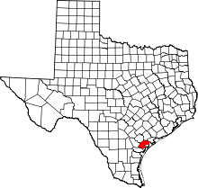 | |
| Towns | ||
| CDP | ||
| Ghost towns | ||
This article is issued from
Wikipedia.
The text is licensed under Creative Commons - Attribution - Sharealike.
Additional terms may apply for the media files.