Skånland
| Skånland kommune Skániid suohkan | ||
|---|---|---|
| Municipality | ||
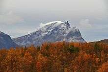
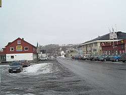 View of Evenskjer | ||
| ||
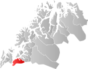 Skånland within Troms | ||
| Coordinates: 68°38′24″N 16°57′26″E / 68.64000°N 16.95722°ECoordinates: 68°38′24″N 16°57′26″E / 68.64000°N 16.95722°E | ||
| Country | Norway | |
| County | Troms | |
| District | Central Hålogaland | |
| Established | 1 July 1926 | |
| Administrative centre | Evenskjer | |
| Government | ||
| • Mayor (2015) | Helene Berg Nilsen (Ap) | |
| Area | ||
| • Total | 495.00 km2 (191.12 sq mi) | |
| • Land | 464.77 km2 (179.45 sq mi) | |
| • Water | 30.23 km2 (11.67 sq mi) 6% | |
| Area rank | #210 in Norway | |
| Population (2017) | ||
| • Total | 3,048 | |
| • Rank | #263 in Norway | |
| • Density | 6.6/km2 (17/sq mi) | |
| • Change (10 years) | 5.7% | |
| Demonym(s) | Skånlending[1] | |
| Time zone | UTC+01:00 (CET) | |
| • Summer (DST) | UTC+02:00 (CEST) | |
| ISO 3166 code | NO-1913 | |
| Official language form | Bokmål | |
| Website |
skanland | |

Skånland (Northern Sami: Skánit) is a municipality in Troms county, Norway. It is part of the Central Hålogaland region, just southeast of the city of Harstad. The administrative centre of the municipality is the village of Evenskjer. Other villages include Grovfjord, Renså, Sandstrand, and Tovik.
The Tjeldsund Bridge in Skånland connects the island of Hinnøya (the largest coastal island in Norway) to the Norwegian mainland.
The 495-square-kilometre (191 sq mi) municipality is the 210th largest by area out of the 422 municipalities in Norway. Skånland is the 263rd most populous municipality in Norway with a population of 3,048. The municipality's population density is 6.6 inhabitants per square kilometre (17/sq mi) and its population has increased by 5.7% over the last decade.[2]
General information
Skånland was established on 1 July 1926 when the large municipality of Trondenes was divided into three municipalities: Sandtorg (population: 4,224) in the southwest, Skånland (population: 2,443) in the southeast, and Trondenes (population: 3,429) in the north. During the 1960s, there were many municipal mergers across Norway due to the work of the Schei Committee. On 1 January 1964, the neighboring municipality of Astafjord (population: 1,120) was merged into Skånland. On the same date, the part of Skånland on the island of Rolla (population: 143) was transferred to neighboring Ibestad Municipality.[3]
The municipalities of Skånland and Tjeldsund voted to merge on 1 January 2020 to form a new, larger municipality of Tjeldsund.[4][5]
Name
The municipality, and the parish, is named after the old Skånland farm (Old Norse: Skánøyjarland), since the first Skånland Church was built there (in 1870). The first element is the genitive case of an old name Skánøy (but the meaning of this is uncertain) and the last element is land which means "land" or "farm". The name might be of Sami origin, meaning "small mountains" (skánit).[6]
Coat of arms
The coat of arms is from modern times (1988). They show a black auger on a gold background. This was chosen since the production of augers, and their use in construction of boats, has long roots in the municipality.[7][8]
Churches
The Church of Norway has three parishes (sokn) within the municipality of Skånland. It is part of the Trondenes prosti (deanery) in the Diocese of Nord-Hålogaland.
| Parish (Sokn) | Church Name | Location of the Church | Year Built |
|---|---|---|---|
| Astafjord | Astafjord Church | Grov | 1978 |
| Skånland | Skånland Church | Evenskjer | 1901 |
| Tovik | Tovik Church | Tovik | 1905 |
Economy
Agriculture is important in Skånland, and there are also many people working in Harstad or at the Harstad/Narvik Airport, Evenes.
Geography
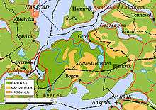
The municipality includes the western and northern part of the Ofoten peninsula, which is bordered by Ofotfjord in the south, Tjeldsundet in the west, and the Astafjorden and Vågsfjorden in the north. Neighbouring municipalities are Evenes to the south, Narvik in the southeast, Tjeldsund in Nordland to the southwest. Harstad in the northwest, across the Tjeldsundet, and Gratangen in the northeast, are located in Troms county. Evenskjer, located in the lowland bordering the Tjeldsundet strait, is the largest village. In the northern part is the smaller village of Grov. Other villages are Renså, Tovik and Sandstrand.
The largest lake is Skoddebergvatnet, and the highest mountain is Skittendalstinden at 1,306 metres (4,285 ft) in the mountainous center of the peninsula. There are calcareous pine forests near Skoddebergvatnet. The lake Niingsvatnet is located on the border with Evenes.
Climate
| Climate data for Evenskjer | |||||||||||||
|---|---|---|---|---|---|---|---|---|---|---|---|---|---|
| Month | Jan | Feb | Mar | Apr | May | Jun | Jul | Aug | Sep | Oct | Nov | Dec | Year |
| Average high °C (°F) | −1.1 (30) |
−0.9 (30.4) |
0.9 (33.6) |
4.2 (39.6) |
9.6 (49.3) |
13.4 (56.1) |
15.9 (60.6) |
15.0 (59) |
10.8 (51.4) |
6.2 (43.2) |
2.2 (36) |
0.2 (32.4) |
6.4 (43.5) |
| Daily mean °C (°F) | −3.7 (25.3) |
−3.4 (25.9) |
−1.7 (28.9) |
1.6 (34.9) |
6.4 (43.5) |
10.0 (50) |
12.4 (54.3) |
11.9 (53.4) |
8.0 (46.4) |
4.0 (39.2) |
−0.1 (31.8) |
−2.6 (27.3) |
3.6 (38.5) |
| Average low °C (°F) | −6.8 (19.8) |
−6.5 (20.3) |
−5.0 (23) |
−1.6 (29.1) |
2.7 (36.9) |
6.8 (44.2) |
9.2 (48.6) |
8.4 (47.1) |
4.8 (40.6) |
1.1 (34) |
−2.9 (26.8) |
−5.3 (22.5) |
0.4 (32.7) |
| Average precipitation mm (inches) | 77 (3.03) |
69 (2.72) |
57 (2.24) |
46 (1.81) |
39 (1.54) |
42 (1.65) |
64 (2.52) |
67 (2.64) |
74 (2.91) |
103 (4.06) |
77 (3.03) |
85 (3.35) |
800 (31.5) |
| Average precipitation days (≥ 1 mm) | 13.9 | 13.8 | 12.6 | 10.2 | 8.4 | 11.0 | 13.6 | 13.5 | 15.2 | 15.8 | 13.8 | 15.0 | 156.8 |
| Source: Norwegian Meteorological Institute[9] | |||||||||||||
Government
All municipalities in Norway, including Skånland, are responsible for primary education (through 10th grade), outpatient health services, senior citizen services, unemployment and other social services, zoning, economic development, and municipal roads. The municipality is governed by a municipal council of elected representatives, which in turn elect a mayor.[10] The municipality falls under the Trondenes District Court and the Hålogaland Court of Appeal.
Municipal council
The municipal council (Kommunestyre) of Skånland is made up of 15 representatives that are elected to four year terms. Currently, the party breakdown is as follows:[11]
| Party Name | Name in Norwegian | Number of representatives | |
|---|---|---|---|
| Labour Party | Arbeiderpartiet | 6 | |
| Conservative Party | Høyre | 6 | |
| Red Party | Rødt | 1 | |
| Socialist Left Party | Sosialistisk Venstreparti | 1 | |
| Liberal Party | Venstre | 1 | |
| Total number of members: | 15 | ||
References
- ↑ "Navn på steder og personer: Innbyggjarnamn" (in Norwegian). Språkrådet. Retrieved 2015-12-01.
- ↑ Statistisk sentralbyrå (2017). "Table: 06913: Population 1 January and population changes during the calendar year (M)" (in Norwegian). Retrieved 2017-09-09.
- ↑ Jukvam, Dag (1999). "Historisk oversikt over endringer i kommune- og fylkesinndelingen" (PDF) (in Norwegian). Statistisk sentralbyrå.
- ↑ "Kommunereform" (in Norwegian). Skånland kommune. Retrieved 2017-09-09.
- ↑ Jensen, Morten (2017-03-06). "Tjeldsund + Skånland = Sant" (in Norwegian). Retrieved 2017-09-09.
- ↑ Rygh, Oluf (1911). Norske gaardnavne: Troms amt (in Norwegian) (17 ed.). Kristiania, Norge: W. C. Fabritius & sønners bogtrikkeri. p. 14.
- ↑ "Troms fylke-beskrivelse" (in Norwegian). Retrieved 2008-12-07.
- ↑ "Civic heraldry of Norway - Norske Kommunevåpen". Heraldry of the World. Retrieved 2018-08-30.
- ↑ "eKlima Web Portal". Norwegian Meteorological Institute. Archived from the original on 2004-06-14.
- ↑ Hansen, Tore, ed. (2016-05-12). "kommunestyre". Store norske leksikon (in Norwegian). Kunnskapsforlaget. Retrieved 2018-08-30.
- ↑ "Table: 04813: Members of the local councils, by party/electoral list at the Municipal Council election (M)" (in Norwegian). Statistics Norway.
External links
- Municipal fact sheet from Statistics Norway (in Norwegian)


| |||||||||
| |||||||||
| |||||||||

| Authority control |
|---|