Sisian
- For the town southwest of Sisian, formerly also called Sisian, see Hatsavan, Syunik.
| Sisian Սիսիան | |
|---|---|
| Town | |
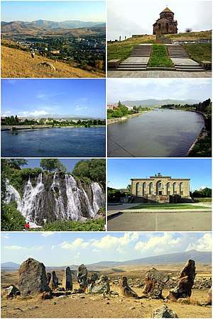 From top left: Sisian skyline • Saint Gregory Church of 689 Sisian with Mount Mets Ishkhanasar • Vorotan River Shaki Waterfall • Sisian Town Hall Zorats Karer archaeological site | |
 Sisian | |
| Coordinates: 39°31′15″N 46°01′56″E / 39.52083°N 46.03222°ECoordinates: 39°31′15″N 46°01′56″E / 39.52083°N 46.03222°E | |
| Country |
|
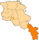
| Province | Syunik |
| Municipality | Sisian |
| First mentioned | 8th century BC |
| Government | |
| • Mayor | Artur Sargsyan |
| Area | |
| • Total | 9 km2 (3 sq mi) |
| Elevation | 1,600 m (5,200 ft) |
| Population (2011 census) | |
| • Total | 14,894 |
| • Density | 1,700/km2 (4,300/sq mi) |
| Time zone | UTC+4 (AMT) |
| Area code(s) | +374 2832 |
| Website | Official website |
| Sources: Population[1] | |
Sisian (Armenian: Սիսիան) is a town and the centre of the urban community of Sisian, in Syunik Province at the south of Armenia. It is located on Vorotan River, 6 km south of the Yerevan-Meghri highway, at a road distance of 217 km southeast of the capital Yerevan, and 115 km north of the provincial centre Kapan.
As of the 2011 census, the population of the town was 14,894. As per the 2016 official estimate, the population of Sisian is around 12,900.
Etymology
The area of present-day Sisian was also known as Sisakan and Sisavan during ancient times and later in the Middle Ages. According to Movses Khorenatsi, the name of Sisakan -and subsequently Sisian- was derived from Sisak,[2] a legendary ancestor of the Armenian princely house of Syuni.[3]
The Turkic name of Gharakilisa -meaning the black church referring to the town's 7th-century church of Saint Gregory- used between the 16th and the 20th centuries for the town, was kept until 1935, when the name Sisavan was restored. Finally in 1940, the town was renamed Sisian.[4]
History
Ancient history and Middle Ages
Historically, the territory of modern-day Sisian was part of Tsghuk canton (Armenian: Ծղուկք գավառ Tsghukk gavar), within historic Syunik; the 7th province of Greater Armenia. It was first mentioned as a notable centre of paganism within the Kingdom of Urartu during the 8th century BC.[5]

Between 331 BC and 428 AD, the region of Sisian -known as Sisakan- was part of the ancient Kingdom of Armenia under the reign of the Orontid, Artaxiad and Arsacid dynasties respectively. During the 4th century, the historic settlement of Shaghat near Sisakan, became the residence of the Siunia princes; the ruling dynasty of historic Syunik. It remained the spiritual and the political center of the region until the end of the 10th century, when the fortified town of Kapan in the southern Baghk canton became the capital of the newly established Kingdom of Syunik in 987 under the protectorate of the Bagratid Kingdom of Armenia.[6]

In 1103, the region was invaded and looted by the Seljuks. After the fall of the Kingdom of Syunik in 1170, Syunik along with the rest of the historic territories of Armenia suffered from the Seljuk, Mongol, Aq Qoyunlu and Kara Koyunlu invasions, respectively between the 12th and 15th centuries.
Persian rule
At the beginning of the 16th century, Sisakan became part of the Erivan Beglarbegi within the Safavid Persia. It was known as Gharakilisa (black church) to the Turkic and Persian rulers of Eastern Armenia. By the beginning of the 18th century, Sisakan was associated with the Armenian military leader David Bek, who led the liberation campaign of the Armenians of Syunik against Safavid Persia and the invading Ottoman Turks. David Bek started his battles in 1722 with the help of thousands of local Armenian patriots who liberated Syunik.[7] In 1750, Sisakan/Gharakilisa became part of the newly formed Karabakh Khanate.
Russian rule
At the beginning of the 19th century, many territories of southern Armenia including the region of Sisakan/Gharakilisa, became part of the Russian Empire as a result of the Treaty of Gulistan signed on 24 October 1813, between Russia and Qajar Persia following the Russo-Persian War of 1804–13. In 1828-30, many Armenian families from the Iranin cities of Khoy and Salmast have migrated to the region. In 1868, Sisakan/Gharakilisa became part of the Zangezursky Uyezd, within the Elisabethpol Governorate of the Russian Empire.
Modern history
After World War I, Sisakan/Gharakilisa became part of the short-lived independent Republic of Armenia between 1918 and 1920. As a result of the Sovietization of Armenia in December 1920, Sisian was included in the breakaway Republic of Mountainous Armenia under the commandment of Garegin Nzhdeh, who fought against the Bolsheviks preserving independence between 26 April and 12 July 1921.


After the Soviet Red Army entered the Zangezur region in July 1921, Sisakan along with the towns of Goris, Kapan and Meghri fell under the Soviet rule. In 1930, Sisian became the centre of the newly founded Sisian raion. The town and the raion were known as Gharakilisa until 1935, and Sisavan between 1935-40. With the operation of Vorotan Cascade during the 1960s, the town of Sisian witness a rapid growth. Many industrial plants and service providing firms were opened in the region. With the gradual development of the town, Sisian was turned into a city of republican subordination within the Armenian Soviet Socialist Republic. The major urban plan of the city was adopted in 1976. An airstrip was opened in 1982 at the northeastern suburbs of the town, adjacent to the main north-south highway of Armenia.
Following the independence of Armenia in 1991, Sisian was incorporated into the newly formed Syunik Province based on the 1995 administrative reforms.
Geography
.jpg)
Sisian is located at the southeast of Armenia, in the mountainous region of historic Syunik. Surrounded with the Zangezur Mountains from the west and Bargushat Mountains from the south, the town is situated on the shores of Vorotan River, at an average height of 1600 above sea level, only 6 km south of the main highway that connect Armenia with the Republic of Artsakh and Iran. Sisian river joins Vorotan at the southern border of the town.
The Sisian mountain pass north of the town is at a height of 2345 meters, connecting the Vorotan plain at the east with the plains of Nakhichevan at the west. The 3563 meters-high Mount Ughtasar is overlooking at Sisian from the north, while the Mount Mets Ishkhanasar (3552 meters) is located 13 km east of the town.
Being nested in an alpine climate zone, the weather of Sisian is characterized with cold/snowy relatively long winters, and mild/warm relatively short summers. The average temperature in January is –5 °C and +18 °C in July. The annual precipitation level is around 400 mm.
Demographics
Many of the ancestors of the citizens in Sisian have migrated from Khoy and Salmast in Iran. Currently, the town a population of ethnic Armenians who belong to the Armenian Apostolic Church with the 7th-century church of Saint Gregory of Sisavan being the main church of the town. It is regulated by the Diocese of Syunik based in Goris.
Here is the population timeline of Sisian since 1931:
| Year | 1931 | 1941 | 1951 | 1959 | 1969 | 1975 | 1979 | 1984 | 1989 | 2001 | 2011 | 2016 |
|---|---|---|---|---|---|---|---|---|---|---|---|---|
| Population | 1,635 | 1,473 | 3,016 | 3,818 | 6,778 | 9,100 | 10,603 | 12,487 | 15,731 | 16,843 | 14,894 | 12,900 |
The healthcare is served by the Sisian Medical Center. The Sisian Military Hospital is based in the nearby village of Aghitu.
Culture
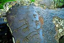
Sisian is surrounded with many historical sites dating back to the Paleolithic Age as well as the early Bronze Age. The Ughtasar Petroglyphs being one of the largest ancient petroglyph sites in the world dating back to the 12th millennium BC,[8] are located few kilometers north of Sisian. The Zorats Karer archaeological site -often referred to in international tourist lore as the Armenian Stonehenge-[9] of the 3rd millennium BC is located 3 km north of Sisian. The remains of a Bronze Age cyclopean fortress are found at the northeastern edge of the town, while 2 other medieval fortresses are found at the west and the northeast of the town. The 7th-century Saint Gregory Church of Sisavan (also known as Surp Hovhannes) is among the major historic landmarks of the town, built in 670-689.
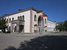
The Sisian History Museum named after Nicholas Adontz is operating since its inauguration in 1989, covering the history of Sisian and the surrounding region.[10] The town is also home to a public library opened in 1935, the Hamo Sahyan house of culture, the Sisian branch of the National Gallery of Armenia opened in 1978.
The music academy of the town is operating since 1960, with around 175 students as of 2017. as well as an academy of fine arts. The town has also an academy of fine arts and children's art, operating since the Soviet days, named after Z. Khachatryan.
The town has 2 newspapers: Vorotan[11] and Vorotanian Ghoghanjner.
Transportation
The Yerevan-Stepanakert highway (M-2 Motorway) that links Armenia with the Republic of Artsakh is only 6 km northeast of Sisian. The Sisian airstrip was opened in 1982 adjacent to the highway. The town is connected with the surrounding villages and towns with a network of regional roads, paved through the mountains passes.
Economy
The economy of Sisian was greatly boosted with the inauguration of the Vorotan Cascade in the early 1960s. Many industrial plants and service firms were opened by the Soviet government, including the production of building materials, reinforced concrete, textile and medical equipments. The industry was enlarged with the foundation of the sewing factory, the Armenian rug production unit, and the dairy products plant. Agriculture was also promoted during the Soviet days, with the establishment of many poultry and pig farms.
Following the independence of Armenia and the resulted economic crisis, most of the industrial and agricultural firms of the Soviet period were forced to shut their doors.
Currently, many plants for the production of building materials, furniture and canned food are operating in the town, including the Sisian Shik mining plant,[12] Bazalt-M plant for building materials (since 2009),[13] and Sisian Ceramics plant.
With its ancient archaeological sites and attractive nature, tourism is an important sector for Sisian and the region. The town is served with many traditional boutique hotels, B&Bs, as well as restaurants and pubs.
Education
As of 2017, Sisian is home to 5 public education schools as well as a number of pre-school kindergartens.
The Sisian branch of the Armenian National Agrarian University was opened in 2004, with seven specialties: agronomy, milk and diary technology, land Management and cadastral survey, economics and management of agrarian production, agrifood system accountancy and audit, veterinary sanitary expertise, and animal husbandry.[14]
The Sisian Adult Education Center is anon-profit organization offering development programs for the population of the town.
Sport

Football, volleyball, futsal, handball, weightlifting, boxing, wrestling and chess are among the popular sports in Sisian. The children and youth sport school of the towns was opened in 1961 by the efforts of volleyball player Manvel Amirkhanyan.[15] Designated for around 500 young trainees, the school was entirely reconstructed and opened in March 2017.[16]
The town is also home to a chess school as well as a football school operating since 2011.
The Sisian Football School Stadium was constructed during 2017. The stadium has an up-to-date artificial turf and a seating capacity of 500 spectators.
International relations
Twin towns – Sister cities
Sisian is twinned with:
Notable natives

- Stepanos Orbelyan (1250-1305), Armenian nobleman, historian, and bishop
- Israel Ori (1658-1711), Armenian nobleman and diplomat
- Nicholas Adontz (1871-1942), Armenian historian
- Hamo Sahyan, (1914-1993), Armenian poet and translator
- Ashot Avagyan, (1958-), Armenian artist
See also
References
- ↑ 2011 Armenia census, Syunik Province
- ↑ (in Armenian) Movses Khorenatsi. History of Armenia, 5th Century (Հայոց Պատմություն, Ե Դար). Annotated translation and commentary by Stepan Malkhasyants. Gagik Sarkisyan (ed.) Yerevan: Hayastan Publishing, 1997, 1.12, p. 88 ISBN 5-540-01192-9.
- ↑ (in Armenian) Harutyunyan, Babken. «Սիսակ» (Sisak). Soviet Armenian Encyclopedia. vol. x. Yerevan, Armenian SSR: Armenian Academy of Sciences, 1984, p. 399.
- ↑ (in Azerbaijani) Regions of Armenian Soviet Socialist Republic
- ↑ Sisian community of Syunik
- ↑ http://hpj.asj-oa.am/969/1/1966-3(221).pdf Kingdom of Syunik
- ↑ Капан (in Russian). abp.am. Retrieved August 28, 2009.
- ↑ Ughtasar: The Petroglyphs of Armenia
- ↑ "The Vorotan Project". Kelsey Museum of Archaeology. 2005. Archived from the original on 9 November 2013. Retrieved 9 November 2013.
- ↑ Sisian History Museum named after Nicholas Adontz
- ↑ Vorotan newspapaer
- ↑ Sisian Shik mining plant
- ↑ Bazalt-M for building materials production
- ↑ Armenian National Agrarian University, Sisian branch
- ↑ ՀՈՒՇԱՄՐՑԱՇԱՐ` Ի ՀԻՇԱՏԱԿ ՍԻՍԻԱՆԻ ՄԱՐԶԱԴՊՐՈՑԻ ՀԻՄՆԱԴԻՐ ՄԱՆՎԵԼ ԱՄԻՐԽԱՆՅԱՆԻ
- ↑ Sisian sport school is reconstructed
| Wikimedia Commons has media related to Sisian. |