Kapan
| Kapan Կապան | ||
|---|---|---|
| Town | ||
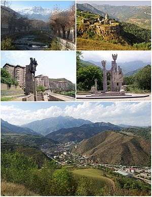 From top left:
| ||
| ||
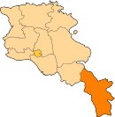
 Kapan Location of Kapan in Armenia | ||
| Coordinates: 39°12′04″N 46°24′54″E / 39.20111°N 46.41500°ECoordinates: 39°12′04″N 46°24′54″E / 39.20111°N 46.41500°E | ||
| Country |
| |
| Province | Syunik | |
| Municipality | Kapan | |
| First mentioned | 5th century | |
| City status | 1938 | |
| Government | ||
| • Mayor | Ashot Hayrapetyan | |
| Area | ||
| • Total | 36 km2 (14 sq mi) | |
| Elevation | 910 m (2,990 ft) | |
| Population (2011 census)[1] | ||
| • Total | 43,190 | |
| • Density | 1,200/km2 (3,100/sq mi) | |
| Time zone | UTC+4 (AMT) | |
| Postal code | 3301-3308 | |
| Area code(s) | (+374) 285 | |
| Website | Official website | |
Kapan (Armenian: Կապան), is a town at the southeast of Armenia, serving as the administrative centre of the urban community of Kapan as well as the provincial capital of Syunik Province. It is located in the valley of the Voghji River, on the northern slopes of Mount Khustup. According to the 2011 census, the population of Kapan is 43,190, slightly declined from 45,711 in the 2001 census.[2] Kapan is the most populous town in the Syunik Province and the entire region of southern Armenia. However, the current population of the town is around 34,600 as per the 2016 official estimate.
The town was known as Ghapan (Armenian: Ղափան) during the Soviet period, derived from its historical name Kapan.
Etymology
The word Kapan originates from the Armenian verb kapel/gabel (կապել), meaning "to lock", and points to an old Armenian geographic term for valleys surrounded by interlocked mountain chains.[3]
History
Ancient history and Middle Ages
The area of modern-day Kapan was first mentioned in the 5th century as a small settlement within the properties of Siunia dynasty. Historically, it was part of the Baghk canton of Syunik, the 9th province of the historic Greater Armenia. By the end of the 10th century, the ruler of Syunik; prince Smbat II, moved to the town of Kapan and founded the Kingdom of Syunik, proclaiming himself a king under the protectorate of the Bagratid Kingdom of Armenia.
In 1103, Kapan was entirely ruined by the Seljuk invaders. After the fall of the Kingdom of Syunik in 1170, Syunik along with the rest of the historic territories of Armenia suffered from the Seljuk, Mongol, Aq Qoyunlu and Kara Koyunlu invasions, respectively between the 12th and 15th centuries.
Iranian rule
At the beginning of the 16th century, Kapan became part of the Erivan Beglarbegi within the Safavid Persia. By the beginning of the 18th century, Kapan was associated with the Armenian military leader David Bek, who led the liberation campaign of the Armenians of Syunik against Safavid Persia and the invading Ottoman Turks. David Bek started his battles in 1722 with the help of thousands of local Armenian patriots who liberated Syunik.[4] The centre of David Bek's struggle was the Baghaberd Fortress northwest of Kapan and Halidzor Fortress southwest of Kapan where he died in 1728. In 1750, Kapan became part of the newly formed Karabakh Khanate. It was turned into a significant urban settlement during the Qajar Persian rule by the end of the 18th century.
Russian rule
In 1813, the territory of historic Syunik including the region of Kapan, officially became part of the Russian Empire as a result of the Russo-Persian War of 1804–13 and the following Treaty of Gulistan signed between Russia and Qajar Persia. In 1828-30, many Armenian families from the Iranin cities of Khoy and Salmast have migrated to the region. In 1868, it became part of the Zangezursky Uyezd, within the Elisabethpol Governorate of the Russian Empire. With the merger of several villages, Kapan was further developed and enlarged to form an important urban community for the region by the last quarter of the 19th century.
Modern history
After World War I, Kapan became part of the short-lived independent Republic of Armenia between 1918 and 1920. As a result of the Sovietization of Armenia in December 1920, Kapan was included in the breakaway Republic of Mountainous Armenia under the commandment of Garegin Nzhdeh, who fought against the Bolsheviks preserving independence between 26 April and 12 July 1921.

After the Soviet Red Army entered the Zangezur region in July 1921, Kapan along with the towns of Goris, Sisian and Meghri fell under the Soviet rule. In September 1930, the Kapan raion was formed by the Soviets. Being the centre of the raion, Kapan was given the status of an urban settlement in 1938 within the Armenian Soviet Socialist Republic.[5]
Following the independence of Armenia in 1991, Kapan became the centre of the newly formed Syunik Province as per the 1995 administrative reforms of the republic. Many streets bearing the name of Bolshevik activists were changed. The town's central square was renamed after Garegin Nzhdeh while the central park of the town was named after Vazgen Sargsyan.
Geography and climate
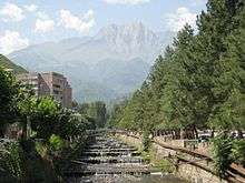
Kapan is the largest town in the Syunik province as well as the entire region of southern Armenia. It is located in the eastern part of Syunik, within the narrow valley of Voghji River on a length of 13 km (8 mi) form the east to the west, at the southeastern slopes of the Zangezur Mountain Range, between the Bargushat and Meghri ridges.
The town is about 80 km (50 mi) north of the Iranian border. With a height of 3201 meters, Mount Khustup is the highest peak of the region. The elevation of Kapan ranges between 750–1050 metres above sea level, with an average height of 910 metres. The tributaries of Voghji River, Vachagan and Kavart flow through the town as well.
Kapan is characterized with hot summers and cold winters. Temperature could reach up to 38 °C (100 °F) during summer, and could fall down to −15 °C (5 °F) during winter.
The Shikahogh State Preserve, founded in 1958, is located around 14 km (9 mi) south of Kapan, near the Shikahogh village. The preserve is home to about 1,100 species of plants, 70 of which have been registered in the Red Book of Armenia. The fauna of Shikahogh has not been fully explored, but studies have already revealed rare species of animals such as leopard, wild goat, bear, viper, and hedgehog.[6][7]
| Climate data for Kapan | |||||||||||||
|---|---|---|---|---|---|---|---|---|---|---|---|---|---|
| Month | Jan | Feb | Mar | Apr | May | Jun | Jul | Aug | Sep | Oct | Nov | Dec | Year |
| Average high °C (°F) | 4.1 (39.4) |
5.8 (42.4) |
11.0 (51.8) |
17.8 (64) |
22.3 (72.1) |
27.1 (80.8) |
30.4 (86.7) |
30.6 (87.1) |
26.0 (78.8) |
19.5 (67.1) |
12.0 (53.6) |
6.5 (43.7) |
17.8 (64) |
| Daily mean °C (°F) | 0.2 (32.4) |
1.7 (35.1) |
6.2 (43.2) |
12.4 (54.3) |
16.8 (62.2) |
21.1 (70) |
24.6 (76.3) |
24.1 (75.4) |
20.0 (68) |
14.0 (57.2) |
7.6 (45.7) |
2.7 (36.9) |
12.6 (54.7) |
| Average low °C (°F) | −3.6 (25.5) |
−2.4 (27.7) |
1.5 (34.7) |
7.0 (44.6) |
11.4 (52.5) |
15.2 (59.4) |
18.8 (65.8) |
17.6 (63.7) |
14.0 (57.2) |
8.6 (47.5) |
3.3 (37.9) |
−1.1 (30) |
7.5 (45.5) |
| Average precipitation mm (inches) | 21 (0.83) |
25 (0.98) |
38 (1.5) |
51 (2.01) |
68 (2.68) |
44 (1.73) |
17 (0.67) |
18 (0.71) |
22 (0.87) |
34 (1.34) |
30 (1.18) |
21 (0.83) |
389 (15.33) |
| Source: Climate-Data.org [8] | |||||||||||||
Demographics
Kapan is a major historic centre of the Armenian civilization within historic Syunik. A sizable Jewish lived in its own quarter in Kapan during the Middle Ages.
During the 1st half of the 19th century, many Russian and German engineers and workers arrived in Kapan to work in the copper mine of the region. In 1850, Greek specialists have also arrived in the town. With the growth of their number, the Greeks built the Saint Catherine Orthodox church near Kapan in 1865.[9]
The population of Kapan was in its peak with 45,711 citizens as per the 2011 census. However, the population has greatly declined during the 1st decade of the 21st century, to reach down to 34,600 as per the 2016 official estimate.
Currently, Kapan is almost entirely populated by ethnic Armenians who belong to the Armenian Apostolic Church. The town's Saint Mesrop Mashtots Church was opened in December 2001, regulated by the Diocese of Syunik of the Armenian Apostolic Church, based in the nearby town of Goris.[10]
Here is the population timeline of Kapan since 1831:
| Historical population | ||||||||||||||||||||||||||||||||||||||
|---|---|---|---|---|---|---|---|---|---|---|---|---|---|---|---|---|---|---|---|---|---|---|---|---|---|---|---|---|---|---|---|---|---|---|---|---|---|---|
|
|
| ||||||||||||||||||||||||||||||||||||
The healthcare in the town is served by the Kapan Medical Center, fully modernized in 2015.
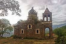
Culture
.jpg)
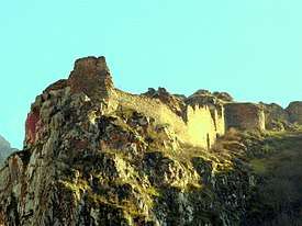
The historic part of Kapan is located around 10 km (6 mi) km west of the modern-day town. Being one of the historic settlements of Armenia, Kapan and the surrounding areas are home to many heritage monuments of the Armenian architecture, including:
- Baghaberd Fortress of the 4th century, also known as the castle of Davit Bek.
- The medieval bridge of Kapan dating back to 871.
- Tatev monastery of the 9th century, founded in the place of an ancient tabernacle well known in ancient times.
- Vahanavank Monastery of the 11th century.
- Halidzor Fortress of the 17th century.

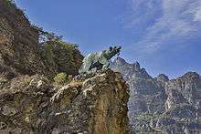
The town is also rich with several statues of prominent Armenian patriotic figures, such as the equestrian statue of Davit Bek erected in 1983, and Garegin Nzhdeh's memorial opened in 2001. Other decorative statues in the town include the bear statue of Kajaran's key erected in 1966, the statue of the girl from Zangezur erected in 1978, the World War II memorial opened in 1987, and the memorial to Armenian Genocide erected in 1988.
Currently, the town is home to the Kapan museum of geology as well as the Kapan history museum named after Shmavon Movsisyan. Other cultural institutions of Kapan include the children's school of fine arts opened in 1972, the house of culture opened in 1977, the children's school of arts opened in 1981, the public library, the children's and youth creativity centre opened in 1990, the Alexander Shirvanzade drama theatre of Kapan, as well as 2 schools of music opened in 1977 and 1986 respectively. A branch of the Modern Art Museum of Yerevan is also operating in Kapan.
Wings of Tatev cableway which connects Halidzor village with the Tatev monastery is located 24 km (15 mi) north of Kapan. It is the longest reversible aerial tramway built in one section only.[11]
Media
Kapan has 2 local TV companies: Khustup TV and Sosi TV. Khustup TV was founded in 2004 and covers the entire region of Syunik.[12] Sosi TV founded in 2012, covers the middle and southern parts of Syunik.
Transportation

The M-2 Motorway that connects the capital Yerevan with southern Armenia, Iranian border, and Artsakh Republic, passes through Kapan.
In late 2008, the road between Kapan and Meghri on the Iranian border was redeveloped. However The railway line Kapan-Kovsakan-Mijnavan is currently inactive.
Prior to the Nagorno-Karabakh War, the nearby defunct airport accommodated the aircraft YAK-40 and AN-14 cargo. In February 2017, the governor of Syunik Province Vahe Hakobyan, announced that the airfield will be promoted to become a modern airport serving the town of Kapan and southern Armenia, and on June 6 a test landing was conducted at the airfield with the governor on board.[13] According to the initiated plan, the reconstruction of Kapan Airport is expected to be completed in 2018, with an estimated cost of US$2 million.[14][15]
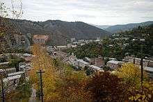
Economy
Kapan is struggling to cope with the realities of post-Karabakh war and post-Soviet society. However, there are signs of growth and development. Kapan is primarily a mining centre, hence its Persian name of the Qajar time معدن (Ma'dan, meaning "mine"). Kapan's industry is dependent on the newly privatized polymetallic deposit, though additional operations have developed including mining support services, commercial scale animal husbandry, and an expanding retail sector. The furniture and textile industries have grown in recent years.
.jpg)
Kapan has been a major centre for the production of many non-ferrous metals. Commercial development of the local deposits began in 1890. Armenian entrepreneurs and French mining engineers obtained concessions to the copper mines and a copper-ore processing plant was built in the city.
Nowadays, Kapan is home to a number of industrial firms operating in the industrial district of the town. The largest firms are the "Kapan CH.SH.SH." for building materials founded in 1947, the Kapan machine tools plant founded in 1972, the "Sonatex" knitting factory founded in 1985, and the "Marila LLC" for meat and dairy products founded in 2010.
Tourism is among the growing sectors in the region of Kapan. The nearby cableway of the Wings of Tatev connecting Halidzor village with the Tatev monastery has greatly contributed in the development of the sector.[16] Many hotels and mountain resorts are set to open in the near future, while the upcoming opening of the Syunik Airport of Kapan will turn the entire region to one of the major touristic destinations in Armenia. Ark Ecological NGO, with headquarters in Kapan, is working since 2013 in the development of ecotourism in the Syunik region, and is currently building hiking trail infrastructure to connect Kapan and Tatev monastery.[17]
Education
Kapan is the education centre of southern Armenia. It has 13 public education schools, 3 music schools and 3 sport academies.
The Kapan campus of the National Polytechnic University of Armenia[18][19] is home to two faculties:
- Faculty of Technologies and sectoral economics,
- Faculty of Natural sciences and communication systems.
Sport
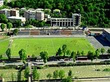
Football is the most popular sport in Kapan. FC Gandzasar Kapan, founded in 2004, represent the town in the Armenian Premier League, playing their home games at the Gandzasar Stadium. The club won the 3rd place of the Armenian Premier League on 3 occasions: in 2008, 2011 and 2012-13. Gandzasar have the highest average attendance at home games in the league.
In May 2013, Gandzasar Kapan opened their footbed football pitches including one with artificial turf. The academy became the first developed technical football centre in the Syunik Province.[20]
Kapan is also home to the Davit Hambardzumyan children and youth sport school, operated by the municipality since its inauguration in 1969. Currently, more than 200 athletes are involved in the sport school. The Kapan Futsal Club is a professional futsal team based in Kapan, playing their home games at the Davit Hambardzumyan children and youth sports school in the Armenian Futsal Premier League.
The Kapan sport school of artistic gymnastics is operating since 1977, currently having around 170 young athletes. In 1989, another sport school specialized in athletics was opened in the town, designated for around 100 young athletes.
Basketball and boxing are also among the widely practiced sports in Kapan.
International relations
Twin towns – Sister cities
Notable natives
- David Ambartsumyan, Soviet Armenian diver, European champion
- Tatoul Markarian, ambassador of Armenia to the European Union
- Armen Movsisyan, former minister of energy of Armenia
- Karen Sargsyan, principal choirmaster of the Armenian Opera Theater
- Lusine Gevorkyan, lead singer of Russian nu metal bands Tracktor Bowling and Louna
- Artsvik Harutyunyan, singer and Armenia's entrant in the Eurovision Song Contest 2017
See also
References
- ↑ 2011 Armenia census, Syunik Province
- ↑ Report of the results of the 2001 Armenian Census, National Statistical Service of the Republic of Armenia
- ↑ Western Armenian Dictionary & Phrasebook: Armenian-English/English-Armenian (Hippocrene Dictionary and Phrasebook). 2006. p. 86
- ↑ Капан (in Russian). abp.am. Retrieved August 28, 2009.
- ↑ About Kapan
- ↑ Igor G. Khorozyan, Pavel I. Weinberg and Alexander G. Malkhasyan: Conservation Strategy for Armenian Mouflon (Ovis orientalis gmelini Blyth) and Bezoar Goat (Capra aegagrus Erxleben) in Armenia. in Status and Protection of globally threatened Species in the Caucasus. CEPF Biodiversity Investments in the Caucasus Hotspot 2004-2009. Edited by Nugzar Zazanashvili and David Mallon (2009).online PDF
- ↑ Armenia Tree Project - Environmental News and Analysis Archived April 27, 2015, at the Wayback Machine.
- ↑ "Climate: Kapan". Climate-Data.org. Retrieved August 14, 2018.
- ↑ On the trails of Greek culture in Kapan
- ↑ The church of Kapan is open
- ↑ World's longest cable car line opens to Armenia. PhysOrg.com. Retrieved on 2011-06-15.
- ↑ About Khustup TV
- ↑ First test landing at Syunik Airport carried out in Armenia with governor on board
- ↑ Company Tied to Syunik Government Gets 25-Year Lease to Operate Kapan Airport
- ↑ Մեծ հույսեր ունեմ, որ մեկ տարվա ընթացքում կկտրենք Կապանի օդանավակայանի ժապավենը. Վահե Հակոբյան
- ↑ World's longest cable car line opens to Armenia. PhysOrg.com. Retrieved on 2011-06-15.
- ↑ . [Repat Armenia.org]. Retrieved on 2016-03-25.
- ↑ Faculty of Natural sciences and communication systems, Kapan campus
- ↑ Faculty of Technologies and sectoral economics, Kapan campus
- ↑ Gandzasar football academy
- ↑ "Interactive City Directory". Sister Cities International. Retrieved 11 March 2014.
External links
| Wikimedia Commons has media related to Kapan. |
| Wikivoyage has a travel guide for Kapan. |