Nea Smyrni
| Nea Smyrni Νέα Σμύρνη | |||
|---|---|---|---|
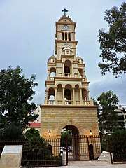
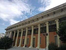 The Nea Smyrni Estia Hall | |||
| |||
 Nea Smyrni Location within the region 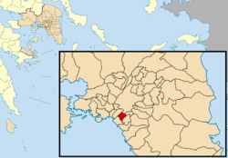 | |||
| Coordinates: 37°57′N 23°43′E / 37.950°N 23.717°ECoordinates: 37°57′N 23°43′E / 37.950°N 23.717°E | |||
| Country | Greece | ||
| Administrative region | Attica | ||
| Regional unit | South Athens | ||
| Government | |||
| • Mayor | Stavros Tzoulakis (Ind.) | ||
| Area | |||
| • Municipality | 3.524 km2 (1.361 sq mi) | ||
| Elevation | 50 m (160 ft) | ||
| Population (2011)[1] | |||
| • Municipality | 73,076 | ||
| • Municipality density | 21,000/km2 (54,000/sq mi) | ||
| Time zone | UTC+2 (EET) | ||
| • Summer (DST) | UTC+3 (EEST) | ||
| Postal code | 171 xx | ||
| Area code(s) | 210 | ||
| Vehicle registration | Z | ||
| Website | http://www.neasmyrni.gr/ | ||

Nea Smyrni (Greek: Νέα Σμύρνη, Néa Smýrni, "New Smyrna") is a municipality and a southern suburb of Athens, Greece. At the 2011 census, it had 73,076 inhabitants.[1] It was named after the city Smyrna (today's İzmir in Turkey), from where a large number of refugees arrived and settled in the Nea Smyrni area following the 1922 population exchange between Greece and Turkey.
History
Although there aren't many details about the ancient history of the area, in 2012, during works, ancient graves were unearthed on the side of Agias Sofias Street. The specific manner of burial is known as 'burial by the roadside'. These ancient findings have already been unveiled by public authorities and are able to be visited.
Nea Smyrni began to be inhabited at the beginning of the twentieth century. Up until that point, it had not been inhabited in a systematic manner. At the time, it was intersected by an avenue which connected Athens and Phalerum, the ancient port of the city.
After the Asia Minor Disaster, the government decided to construct a settlement in the area for the refugees from Smyrni. Construction of this settlement began in 1926. In 1928, the population was just 210. By 1933, the area had become a true town with a population of 6,500. By 1940, there were 15,000 inhabitants. In 1944, with the end of the war, Nea Smyrni became a municipality.
Nea Smyrni was the site of multiple clashes between British Army forces and ELAS resistance forces during the so-called Dekemvriana of 1944.
After the civil war, Nea Smyrni was incorporated into Athens.
Geography
Nea Smyrni is located about 4 km (2 mi) southwest of central Athens. The municipality has an area of 3.524 km2.[2] Its built-up area is continuous with those of Athens and the neighbouring suburbs. It is the second-most densely populated municipality in Greece, following Kallithea. The main thoroughfare is Andrea Syngrou Avenue, which forms the northwestern border of the municipality and connects it with central Athens and the coast.
Alsos Neas Smyrnis
Alsos Neas Smyrnis (Alsos meaning 'grove' or 'small wood') has an area of fifty acres and is bounded by Eleftheriou Venizelou, Ephesou, Kordeliou and Patriarchou Ioakeim III Avenues. The Alsos consists mainly (20%) of woodland trees (Aleppo pine, stone pine, cypress etc.) and ornamental trees (20%). In addition, most of this green space is covered in shrubs (cranberry, velvetleaf, myoporum and pyracantha). Today, conifers make up about 60% of the plant capacity. The plant material of the Alsos consists mainly of monoculture and introduced plants planted in very high density. Two fountains complete the architectural makeup of the area. The whole park is surrounded by iron railings.[3]
Sporting teams
The sport clubs based in Nea Smyrni are Panionios G.S.S., multisport club founded in Smyrna, in 1890 and AONS Milon, multisport club founded in 1928.
| Sport clubs based in Nea Smyrni | |||
|---|---|---|---|
| Club | Founded | Sports | Achievements |
| Panionios | 1890 | Football, Basketball, Water Polo, Track and Field and other sports | Panhellenic titles in football, basketball, basketball women and other honours. |
| AONS Milon | 1928 | Basketball, Volleyball and other sports | Panhellenic titles in volleyball, earlier presence in A1 Ethniki basketball |
Sites of interest
- Nea Smyrni Stadium, built in 1939, renovated in 1988. Panionios FC plays in the stadium.
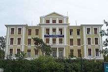
- Nea Smyrni Indoor Hall, holds up to 1,832 persons.
- Nea Smyrni Square (Greek: Πλατεία Νέας Σμύρνης Platía Néas Smýrnis).
- Nea Smyrni Park, a 5-hectare centrally located park with about 40% trees.[4]
- Estia Nea Smyrni, a cultural association.
Neighbourhoods
- Faros
- Agia Fotini
- Alsos
- Kendro (Center)
- Chrisaki
- Agia Paraskevi
- Mitilineika
- Loutra
- Ano Nea Smyrni (Upper Nea Smyrni)
Churches
- Agia Fotini
- Agia Paraskevi
- Agioi Anargiroi
- Agios Charalambos
- Agios Andreas
- Agioi Theodoroi (Greek Old Calendarists)
- Taxiarches (cemetery church)
Nea Smyrni is the seat of a similarly-titled metropolitan diocese. The current Metropolitan bishop of Nea Smyrni is Simeon Koutsas.
Notable people
- Semeli Akrita
- Maria Iliaki
- Polina, singer
- Constantine Psachos, musician
- Makis Angelopoulos, businessman
Twin towns – sister cities
Historical population
| Year | Population |
|---|---|
| 1928 | 210 |
| 1933 | 6,500 |
| 1940 | 15,114 |
| 1951 | 22,074 |
| 1961 | 32,865 |
| 1971 | 42,512 |
| 1981 | 67,408 |
| 1991 | 69,749 |
| 2001 | 73,986 |
| 2011 | 73,076 |
See also
| Wikimedia Commons has media related to Nea Smyrni. |
References
- 1 2 "Απογραφή Πληθυσμού - Κατοικιών 2011. ΜΟΝΙΜΟΣ Πληθυσμός" (in Greek). Hellenic Statistical Authority.
- ↑ "Population & housing census 2001 (incl. area and average elevation)" (PDF) (in Greek). National Statistical Service of Greece.
- ↑ http://www.attiko-prasino.gr/
- ↑ "ΑΤΤΙΚΟ ΠΡΑΣΙΝΟ > Χώροι Πρασίνου > Νέα Σμύρνη > Άλσος Νέας Σμύρνης > Γενική Παρουσίαση". attiko-prasino.gr.
Places adjacent to Nea Smyrni | ||||||||||
|---|---|---|---|---|---|---|---|---|---|---|
| ||||||||||
Administrative division of the Attica Region | ||
|---|---|---|
| Regional unit of Central Athens | 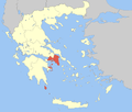 | |
| Regional unit of North Athens | ||
| Regional unit of West Athens | ||
| Regional unit of South Athens | ||
| Regional unit of Piraeus | ||
| Regional unit of East Attica | ||
| Regional unit of West Attica | ||
| Regional unit of Islands | ||
| ||