Tumanyan, Armenia
- For the nearby town formerly called Tumanyan, see Dsegh.
Coordinates: 41°00′10″N 44°38′54″E / 41.00278°N 44.64833°E
| Tumanyan Թումանյան | |
|---|---|
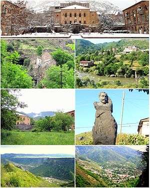 From top left: Tumanyan Central square Kobayr monastery • Debed River House of culture • Statue of Hovhannes Tumanyan Debed River gorge • Tumanyan landscape | |
 Tumanyan Թումանյան | |
| Coordinates: 40°59′12″N 44°39′21″E / 40.98667°N 44.65583°E | |
| Country | Armenia |
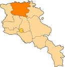
| Marz (Province) | Lori |
| Founded | 1926 |
| Government | |
| • Mayor | Levon Zavaryan |
| Area | |
| • Total | 1 km2 (0.4 sq mi) |
| Elevation | 810 m (2,660 ft) |
| Population (2011 census) | |
| • Total | 1,710 |
| • Density | 1,700/km2 (4,400/sq mi) |
| Time zone | UTC+4 ( ) |
| Website | Official website |
| Sources: Population[1] | |
Tumanyan (Armenian: Թումանյան), is a town and urban municipal community in the Lori Province of Armenia, located 149 km north of the capital Yerevan, and 38 km north of the provincial centre Vanadzor. As of the 2011 census, the population of Tumanyan is 1,710, declining from 2,864 reported in 1964.[2] Currently, the town has an approximate population of 1,000 as per the 2016 official estimate. The nearby villages of Kober kayaran, Shamut, Lorut, Ahnidzor, Atan, Marts and Karinj are also part of the Tumanyan community.
Etymology
By its foundation in 1926, town was known as Dzaghidzor (Armenian: Ձաղիձոր). However, it was renamed Tumanyan in 1951, in honour of the famous Armenian poet Hovhannes Tumanyan.
History
Historically, the area of modern-day Tumanyan was included in the Dzorapor (Armenian: Ձորափոր) canton of the historic Gugark province, the 13th province of Greater Armenia. Prior to the foundation of the Republic of Armenia in 1918, the area was part of the Borchali uyezd of Tiflis Governorate, within the Russian Empire. In late 1918, Armenia and Georgia fought a border war over the region of Lori. In January 1919, the Lori neutral zone was established by the British forces. Following Armenia's sovietization in December 1920, Lori was finally incorporated into Soviet Armenia on 11 February 1921.
In 1926, the village of Dzaghidzor was founded on the right bank of Debed river. In 1930, the it was included within the newly founded Tumanyan raion. In 1934, refractory metals mines were found 3.5 km north of Dzaghidzor village. The production of fireproof materials extracted from the mines of Dzaghidzor was launched in 1939.
With the rapid growth of the village, Dzaghidzor was granted the status of an urban-type settlement in 1947. In 1951, the settlement was renamed Tumanyan. During the 1950s, the Kober railway station was opened on the left bank of Debed river, around 1 km northwest of Tumanyan,[3] to serve the Tumanyan fireproof materials factory opened in 1951.[4]
In 1995, the government of independent Armenia reaffirmed the status of Tumanyan as an urban settlement within the Lori Province. Besides the town of Tumanyan, the nearby villages of Atan, Shamut, Karinj, Lorut, Marts, Kober kayaran and Ahnidzor are also under the jurisdiction of the municipality of Tumanyan.
Geography
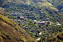
Tumanyan is situated on a plateau on the right bank of Debed river at a height of 810 meters above sea level. It occupies an area of around 1 km².
Tumanyan is characterized with a Subtropical climate. The weather is relatively hot during the summer season and mildly cold during winter.
The annual precipitation level ranges between 500 and 600 mm.
Demographics
The resident of Tumanyan are entirely Armenians who belong to the Armenian Apostolic Church. The population of Tumanyan reached its peak during the 1960s when the town had around 3,000 people. However, the population is declining since the 1970s, due to the rapid downfall in the economy of the region.
Here is the population timeline since the foundation of Tumanyan in 1926:
| Year | 1926 | 1959 | 1964 | 1980 | 2001 | 2011 |
|---|---|---|---|---|---|---|
| Population | 42 | 2640 | 2864 | 1881 | 1909 | 1710 |
Culture
The 12th-century Armenian Monastery of Kobayr is located at the northern outskirts of Tumanyan. Many kahchkars (cross-stones) are also found in the town, dating back to the 9th, 13th and 14th centuries. A ruined fortress known as Avanakar dating back to the 14th century is found at the southern outskirts of the town.
Currently, Tumanyan is served by a cultural palace located at the central square, a public library, an ethnographic museum and an art academy. The statue of poet Hovhannes Tumanyan is found at the northwestern entrance to the town.
The town of is home to 2 public education schools as well as a pre-school kindergarten.
Transportation
Tumanyan is located on the on M-6 Motorway that connects Yerevan with Tbilisi via Vanadzor.
The Kober railway station operating since the 1950s is located on the left bank of Debed river, around 1 km northwest of Tumanyan.
Economy

The growth of the town during the 1950s was mainly based on the establishment of Tumanyan fireproof materials factory in 1951. It was founded on the basis of the nearby refractory metals mines. However, after the dissolution of the Soviet Union, the production of the plant was significantly dropped.
Currently, the population of the town are mainly involved in agriculture and cattle-breeding. Many small industrial plants, such as food-processing, dairy products, garments and building materials production are also found in Tumanyan.
Sport

Football is among the most popular sport in Tumanyan. There is a football training field at the centre of the town.
Other popular sports in Tumanyan include martial arts, wrestling and chess.
See also
References
| Wikimedia Commons has media related to Tumanyan. |