L'Amoreaux
| L'Amoreaux | |
|---|---|
| Neighbourhood | |
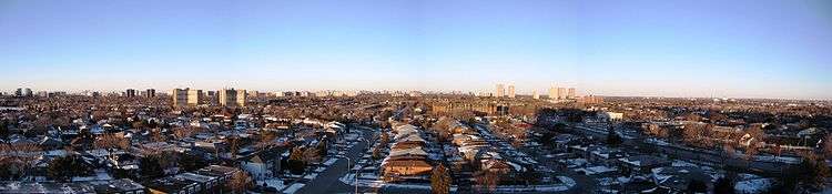 A view above L'Amoreaux, looking west | |
 | |
 Location within Toronto | |
| Coordinates: 43°47′40″N 79°19′33″W / 43.79444°N 79.32583°WCoordinates: 43°47′40″N 79°19′33″W / 43.79444°N 79.32583°W | |
| Country |
|
| Province |
|
| City |
|
| Community | Scarborough |
| Changed Municipality |
1998 Toronto from |
| Government | |
| • MP | Jean Yip (Scarborough—Agincourt) |
| • MPP | Soo Wong (Scarborough—Agincourt) |
| • Councillor | Jim Karygiannis (Ward 39 Scarborough—Agincourt) |
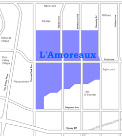
L'Amoreaux is a neighbourhood in Toronto, Ontario, Canada, situated east of Victoria Park Avenue, south of McNicoll Avenue, west of Kennedy Road and north of Huntingwood Drive. L'Amoreaux is named after Josue L'Amoreaux (1738–1834), a French Huguenot loyalist who settled in the area. Prior to the amalgamation of Toronto in 1998, L'Amoreaux was a neighbourhood of the former city of Scarborough, and prior to the amalgamation of municipalities, it formed part of the town of Agincourt.
History
L'Amoreaux arrived via New York City with wife Elizabeth, seven children and two nephews in 1816. The family spread throughout the Greater Toronto Area and eventually many later relatives returned to the United States. L'Amoreaux sold his land and moved to Markham, and the remaining family left Scarborough by 1840. St. Paul L'Amoreaux Church in Scarborough and Ebenzer United Church in Markham contains graves of L'Amoreaux descendants. L'Amoreaux Park, L'Amoreaux Community Centre and L'Amoreaux Tennis Centre perpetuate the L'Amoreaux name in the area.
In 2000, farmland being developed for housing just north of L'Amoreaux Park North revealed the existence of a long-defunct Wyandot First Nations village. Similar in size to the Iroquoian Village at Crawford Lake Conservation Area, it had several longhouses. The site is known as the "Alexandra Site". After examination of the site and retrieval of artifacts, the site is now single-family housing. The site did not have any burial sites. Plaques were erected in L'Amoreaux Park North to mark the discovery. Archaeologists believe that the site is related to other sites found in Scarborough, such as Taber Hill and Thomson Park.
Character
The area is a suburban residential neighbourhood predominantly of single-family detached homes and townhomes, dating from the late 1950s, as well as some mid to high-rise apartment buildings and condominiums. One will find many tree-lined streets, huge sidewalks, and winding roads. At the corner of Warden Avenue and Finch Avenue is Bridlewood Mall, an enclosed mall that is the largest retail building in the area. The mall is at the center of the Bridlewood housing development, with several apartment buildings adjacent.
There are many developments currently underway and others that have recently reached completion on vacated Ontario Hydro corridors.
Demographics
Today, the neighbourhood shows little French flavour, although it is quite diverse. Today, there is a mix of ethnicities, with Chinese being the most predominant. South Asian and Chinese are the two biggest ethnic groups in the area and just under 20% of residents speak the Chinese language at home. The neighbourhood's residents are mainly middle class citizens.
Schools

- L'Amoreaux Collegiate Institute is a public high school on Warden Avenue. It was designed by noted Japanese-Canadian architect Raymond Moriyama. It opened in the fall of 1973.
- Beverly Glen Junior Public School is located on Beverly Glen Blvd, and was constructed in 1970 in what was known as Bridlewood Phase 7.
- Dr Norman Bethune Collegiate Institute is a public high school located north-east of Warden Avenue and McNicoll.
- Brookmill Junior Public School is a public elementary school located north-east of Finch and Warden.
- Sir John A. Macdonald Collegiate Institute is a public high school on Pharmacy Avenue. It opened in the fall of 1964.
- Silver Springs Public School is a public elementary school east of L'Amoreaux Park.
- Timberbank Junior Public School is a public elementary school located south-east of Finch and Warden.
- St. Aidan Roman Catholic School is a Roman Catholic elementary school located on Finch Ave. east between Warden and Birchmount.
- JB Tyrrell Senior Public School is a public middle school on Corinthian Boulevard south-east of Finch and Pharmacy.
- Fairglen Junior Public School is a public elementary school located at Pharmacy and Sesame Street.
- Sir Ernest MacMillan Senior Public School is a public middle school located on Huntsmill Boulevard.
- Mary Ward Catholic Secondary School is a self-directed Catholic high school located on the north-west corner of Kennedy Road and McNicoll Avenue. Attached to the school is the L'Amoreaux Community Recreation Centre.
- Sir Samuel B. Steel which is located at Huntsmill Blvd. and Eagle Point Road
- Terry Fox which is North of Dr. Norman Bethune
- David Lewis which is South-east of Dr. Norman Bethune
Notable residents
- Boi-1da, hip hop producer
- Maestro Fresh-Wes, hip hop musician
See also
Places adjacent to L'Amoreaux | ||||||||||
|---|---|---|---|---|---|---|---|---|---|---|
| ||||||||||