Shigar District
| Shigar | |
|---|---|
| District | |
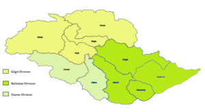 Map of Gilgit-Baltistan showing Shigar and other districts | |
| Coordinates: 35°26′N 75°44′E / 35.433°N 75.733°E | |
| Country | Pakistan |
| Province | Gilgit-Baltistan |
| Headquarters | Shigar |
| Area | |
| • Total | 8,500 km2 (3,300 sq mi) |
| Population | |
| • Estimate (1998) | 109,000 |
| Time zone | UTC+5 (PST) |
Shigar District, a political sub-division of Pakistan, is part of Baltistan and currently constitutes one of the ten districts of the Gilgit–Baltistan territory of Pakistan. It is bounded on the south and southwest by Skardu district, on the east by Ghanche District, on the north by Xinjiang (China), on the northwest by and Hunza, Nagar, Gilgit Districts. The district was formed in 2015, prior to which it was part of the Skardu District.[1].
Shigar town is the capital of Shigar District. Shigar town is 30 away from Skardu city. Shigar is the home of world's second highest peak K-2.
References
- ↑ "Dividing governance: Three new districts notified in G-B - The Express Tribune". The Express Tribune. 2015-07-26. Retrieved 2017-10-15.
| Wikimedia Commons has media related to Shigar District. |
| Passes | 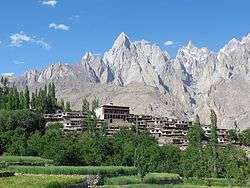 | |
|---|---|---|
| Valleys | ||
| Cities and towns | ||
| Rivers, glaciers and lakes | ||
| Architecture | ||
| See also | ||
This article is issued from
Wikipedia.
The text is licensed under Creative Commons - Attribution - Sharealike.
Additional terms may apply for the media files.