Charyn Canyon
| Charyn Canyon | |
|---|---|
| Charyn Canyon | |
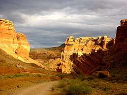 Charyn Canyon, view down to Valley of Castles | |
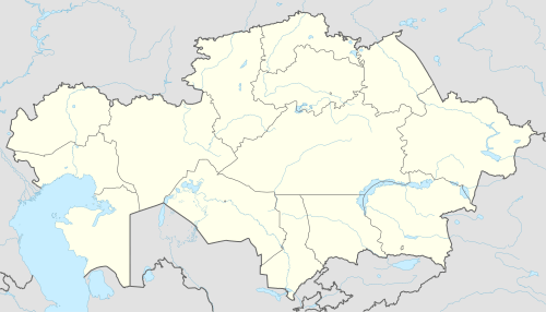 Charyn Canyon Location in Kazakhstan | |
| Location | Almaty, Kazakhstan |
| Long-axis length | 80 kilometres (50 mi) |
| Geography | |
| Coordinates | 43°21′29″N 79°05′33″E / 43.3581°N 79.0925°ECoordinates: 43°21′29″N 79°05′33″E / 43.3581°N 79.0925°E |
| Watercourses | Sharyn River |
Charyn Canyon (also known as Sharyn Canyon) is a canyon on the Sharyn River in Kazakhstan (200 kilometres (120 mi) east of Almaty, close to the Chinese border). The canyon is roughly 90 kilometres (56 mi) in length.[1] It is part of the Charyn National Park (established on 23 February 2004), and is located within the territory of the Uygur District, Raiymbek District and Enbekshikazakh District (of the Almaty Province). Over time, the canyon has gained colorful formations of varying shapes and sizes. Though it is much smaller than the Grand Canyon, it has been described as being equally impressive.[1][2][3][4]
Etymology
Some scholars think that the name of the river is derived from the Uyghur word 'Sharyn' meaning "ash tree". There is also another interpretation that it is a derivative of the Turkic root word 'Char', which means a "precipice". Both these interpretations fit the site conditions where the terrain is precipitous, and ash trees are found.[1]
Features
The canyon consists of a formation along the banks of the Charyn River of approximately 80 kilometres (50 mi) (90 kilometres (56 mi) is also stated). The river has a total length of 393 kilometres (244 mi).[4] The river originates from the Tian Shan Mountains (meaning: "Heavenly Mountains",[5]) that is spread over the arid semi-desert to eastern Almaty.[1] In various places, it attains a depth of 150 to 300 metres (490 to 980 ft).[2]
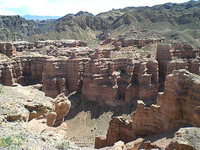
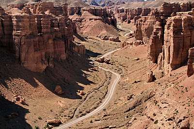
The geological formation of the canyon consists of sedimentary red sandstone that has been subject to the "atmogenic process" (defined in Websters dictionary as "atmospheric origin by condensation, wind action, or deposition from volcanic vapors"[6]) of water and wind erosion resulting in "rare and colourful formations" in the form of sculptures.[1][2] [7] One part of the canyon is known as Valley of Castles (Dolina Zamkov) for its unusual rock formations, and its length is 3 kilometres (1.9 mi) with a depth of 100 metres (330 ft).[1]
The canyon can be accessed from Almaty on the main road that passes through the villages Chilik, Baiseit, and Kokpek (at a distance of about 190 kilometres (120 mi)). From there, a signposted road leads to the parking area of the canyon over a distance of 9 kilometres (5.6 mi), and passes through the Sharyn (or Charyn) National Park. From the parking area, there is a track that leads to the canyon. Another path from the park (which is 1 kilometre (0.62 mi) in length), leads to an area where views of the canyon are more scenic.
Tourism
The Charyn Canyon stretches 154km along the Charyn River (one of the deepest rivers of the Northern Tien Shan mountains). Wind, water and sand sculpted Charyn’s red sandstone to form its shapes and shades. Some of the cliffs resemble particular figures, which is why some parts of the canyon are also called the "Valley of Castles", the Witche’s Gorge, and the Ghosts Gorge.[8]
The multicolored rock layers are the product of different stages of sediment deposits, which includes volcanic lava rocks at the bottom, andred debris on top. The Charyn Canyon consists of 5 different canyons: the Valley of Castles, the Temirlik Canyon, the Yellow Canyon, the Red Canyon and the Bestamak Canyon. The Valley of Castles is the most popular part of the Charyn Canyon.
Adventure sports activities in the river include white-water rafting and canoeing. Fishing for the local species of fish called "Naked Osman" is also common.[1] Further downstream of the canyon, a dry zone of the gorge called the Red canyon or "Valley of Castles" is located. It stretches over about 1km and has a depth of about 100 metres (330 ft). There is a track at the valley of the gorge that has naturally sculpted red stone formations.[1]
The Relic Forest is located approximately 20 kilometres (12 mi) away from the canyon. The forest, located under the umbrage of the canyon. is known as the "Sogdian ash" (Ash Tree) (a tree that is said to be a derivative from the Ice age). The site is considered unique on various accounts. It was declared a protected reserve in 1964. It is now integrated with the Charyn National Park. Apart from the Ash Tree, other tree categories in the area include the willow, poplar, and barberry.
The area can be accessed from a road originating at Almaty that passes through Kokpek, Shonzy and Zharkent.[1] One of the most stricking parts of the canyon is known as "Valley of Castles", for its unusual rock formations created by wind, sun, and water and vertical cliffs reminding the ancient castles.
Gallery
References
- 1 2 3 4 5 6 7 8 9 Brummell 2012, p. 170.
- 1 2 3 Mayhew, Bloom & Clammer 2010, p. 147.
- ↑ Waters 2006, p. 72.
- 1 2 "The State National park of Charyn". Official web site of the Government of Kazakastan. Retrieved 23 November 2015.
- ↑ Pang Guek Cheng (2001). Kazakhstan. Marshall Cavendish. pp. 10–. ISBN 978-0-7614-1193-2.
- ↑ "atmogenic". Merriam Webster Dictionary. Retrieved 15 January 2016.
- ↑ "Asia, Kyrgyzstan and Kazakhstan". ecosystema.ru. Retrieved 23 November 2015.
- ↑ Travel Guide Charyn Canyon in Kazakhstan
Bibliography
- Brummell, Paul (1 March 2012). Kazakhstan. Bradt Travel Guides. ISBN 978-1-84162-369-6.
- Mayhew, Bradley; Bloom, Greg; Clammer, Paul (2010). Central Asia. Lonely Planet. ISBN 978-1-74179-148-8.
- Waters, Bella (2006). Kazakhstan in Pictures. Twenty-First Century Books. ISBN 978-0-8225-6588-8.
| History |
|  | |||||||||
|---|---|---|---|---|---|---|---|---|---|---|---|
| Geography |
| ||||||||||
| Politics | |||||||||||
| Economy | |||||||||||
| Culture |
| ||||||||||