Sehili, Arizona
| Sehili, Arizona | |
|---|---|
| Census-designated place | |
 Sehili | |
| Coordinates: 36°16′47″N 109°10′04″W / 36.27972°N 109.16778°WCoordinates: 36°16′47″N 109°10′04″W / 36.27972°N 109.16778°W | |
| Country | United States |
| State | Arizona |
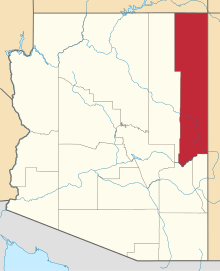
| County | Apache |
| Area[1] | |
| • Total | 0.65 sq mi (1.69 km2) |
| • Land | 0.65 sq mi (1.69 km2) |
| • Water | 0.00 sq mi (0.00 km2) |
| Elevation | 7,150 ft (2,180 m) |
| Population (2010) | |
| • Total | 135 |
| • Estimate (2016)[2] | N/A |
| Time zone | UTC-7 (MST) |
| FIPS code | 04-65400 |
| GNIS feature ID | 0012750 |
Sehili[3] is a census-designated place (CDP) in Apache County, Arizona, United States. The population was 135 at the 2010 census.[4]
Geography
Sehili is located at 36°16′47″N 109°10′04″W / 36.27972°N 109.16778°W (36.2797, −109.1679),[3] directly east of the Tsaile CDP.
According to the United States Census Bureau, the CDP has a total area of 0.66 square miles (1.7 km2), all of it land.[4]
Demographics
| Historical population | |||
|---|---|---|---|
| Census | Pop. | %± | |
| U.S. Decennial Census[5] | |||
References
- ↑ "2016 U.S. Gazetteer Files". United States Census Bureau. Retrieved Jul 18, 2017.
- ↑ "Population and Housing Unit Estimates". Retrieved June 9, 2017.
- 1 2 U.S. Geological Survey Geographic Names Information System: Sehili
- 1 2 "Geographic Identifiers: 2010 Demographic Profile Data (G001): Sehili CDP, Arizona". U.S. Census Bureau, American Factfinder. Retrieved April 30, 2013.
- ↑ "Census of Population and Housing". Census.gov. Retrieved June 4, 2016.
This article is issued from
Wikipedia.
The text is licensed under Creative Commons - Attribution - Sharealike.
Additional terms may apply for the media files.