Blue Gap, Arizona
| Blue Gap, Arizona | |
|---|---|
| Unincorporated community | |
 Blue Gap, Arizona  Blue Gap, Arizona | |
| Coordinates: 36°10′15″N 109°56′47″W / 36.17083°N 109.94639°WCoordinates: 36°10′15″N 109°56′47″W / 36.17083°N 109.94639°W | |
| Country | United States |
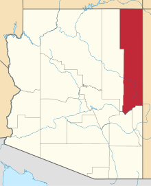
| State | Arizona |
| County | Apache |
| Elevation[1] | 6,496 ft (1,980 m) |
| Time zone | UTC-7 (Mountain (MST)) |
| ZIP code | 86520 |
| Area code(s) | 928 |
| GNIS feature ID | 25260[1] |
Blue Gap (Navajo: Tachíí/Bis Dootłʼizh Ndeeshgiizh) is an unincorporated community in Apache County, Arizona, United States.[1] Blue Gap is on the Navajo Nation 22 miles (35 km) west of Chinle. The community is in Polacca Wash near State Road 291 in western Apache County.[2] Blue Gap has a post office with ZIP code 86520.[3]
References
- 1 2 3 U.S. Geological Survey Geographic Names Information System: Blue Gap, Arizona
- ↑ Blue Gap, Arizona, 7.5 Minute Topographic Quadrangle, USGS, 1972
- ↑ ZIP Code Lookup Archived June 15, 2011, at the Wayback Machine.
This article is issued from
Wikipedia.
The text is licensed under Creative Commons - Attribution - Sharealike.
Additional terms may apply for the media files.