Sandtown, New Jersey
| Sandtown, New Jersey | |
|---|---|
| Unincorporated community | |
 Looking west along New Freedom Road | |
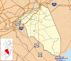 Sandtown Location in Burlington County (Inset: Burlington County in New Jersey)  Sandtown Sandtown (New Jersey)  Sandtown Sandtown (the US) | |
| Coordinates: 39°54′25″N 74°47′18″W / 39.90694°N 74.78833°WCoordinates: 39°54′25″N 74°47′18″W / 39.90694°N 74.78833°W | |
| Country |
|
| State |
|
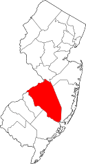
| County | Burlington |
| Township | Southampton |
| Elevation | 11 m (36 ft) |
| Time zone | UTC-5 (Eastern (EST)) |
| • Summer (DST) | UTC-4 (Eastern (EDT)) |
| GNIS feature ID | 880256[1] |
Sandtown is an unincorporated community located within Southampton Township in Burlington County, New Jersey, United States.[2] The settlement is located at the modern-day intersection of Sandtown Road and New Freedom Road. Little Creek runs to the west of Sandtown and forms the border between Southampton and Medford townships. A small grouping of homes is located along the two aforementioned roads in Sandtown while the remainder of the Southampton side of the creek consists of farmland. Route 70 is the closest major road near Sandtown.[3]
References
- ↑ "Geographic Names Information System (GNIS)". Retrieved July 2, 2011.
- ↑ Locality Search, State of New Jersey. Accessed June 9, 2016.
- ↑ Google (August 14, 2016). "Aerial view of Sandtown" (Map). Google Maps. Google. Retrieved August 14, 2016.
This article is issued from
Wikipedia.
The text is licensed under Creative Commons - Attribution - Sharealike.
Additional terms may apply for the media files.