Cookstown, New Jersey
| Cookstown, New Jersey | |
|---|---|
| Unincorporated community | |
.JPG) Gen. Edward S. Godfrey House on Main Street in Cookstown | |
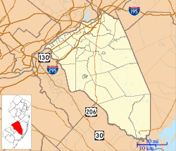 Cookstown Location of Cookstown in Burlington County (Inset: Location of county within the state of New Jersey)  Cookstown Cookstown (New Jersey)  Cookstown Cookstown (the US) | |
| Coordinates: 40°02′56″N 74°33′45″W / 40.04889°N 74.56250°WCoordinates: 40°02′56″N 74°33′45″W / 40.04889°N 74.56250°W | |
| Country |
|
| State |
|
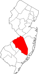
| County | Burlington |
| Township | New Hanover |
| Elevation[1] | 82 ft (25 m) |
| Time zone | UTC-5 (Eastern (EST)) |
| • Summer (DST) | UTC-4 (EDT) |
| GNIS feature ID | 875620[1] |
Cookstown is an unincorporated community located within New Hanover Township in Burlington County, New Jersey, United States.[2] Located near Fort Dix, the area is served as United States Postal Service ZIP Code 08511.
As of the 2000 United States Census, the population for ZIP Code Tabulation Area 08511 was 1,133.
References
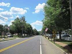
Looking south along Main Street in Cookstown
- 1 2 "Cookstown". Geographic Names Information System. United States Geological Survey.
- ↑ Locality Search, State of New Jersey. Accessed March 15, 2015.
External links
This article is issued from
Wikipedia.
The text is licensed under Creative Commons - Attribution - Sharealike.
Additional terms may apply for the media files.