Davisville, New Jersey
| Davisville, New Jersey | |
|---|---|
| Unincorporated community | |
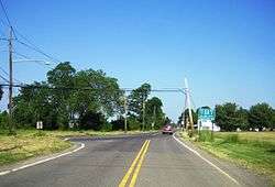 Looking west towards CR 528 in Davisville | |
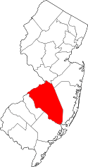
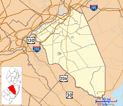 Davisville Location of Davisville in Burlington County (Inset: Location of county within the state of New Jersey)  Davisville Davisville (New Jersey)  Davisville Davisville (the US) | |
| Coordinates: 40°06′35″N 74°37′05″W / 40.10972°N 74.61806°WCoordinates: 40°06′35″N 74°37′05″W / 40.10972°N 74.61806°W | |
| Country |
|
| State |
|
| County | Burlington |
| Township | Chesterfield |
| Elevation[1] | 102 ft (31 m) |
| Time zone | UTC-5 (Eastern (EST)) |
| • Summer (DST) | UTC-4 (EDT) |
| GNIS feature ID | 883070[1] |
Davisville is an unincorporated community located within Chesterfield Township in Burlington County, New Jersey, United States. The settlement, located at the intersection of County Route 528 and Chesterfield-Arneytown Road (CR 664), is in a rural area in the eastern portion of the township. It consists mainly of farmland with some houses dotting the few roads that pass through the area.[2]
References
- 1 2 "Davisville". Geographic Names Information System. United States Geological Survey.
- ↑ Google (March 15, 2015). "Davisville, Chesterfield Township, Burlington County, New Jersey 08515" (Map). Google Maps. Google. Retrieved March 15, 2015.
This article is issued from
Wikipedia.
The text is licensed under Creative Commons - Attribution - Sharealike.
Additional terms may apply for the media files.