Sandown, New Hampshire
| Sandown, New Hampshire | |
|---|---|
| Town | |
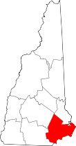
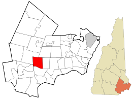 Location in Rockingham County and the state of New Hampshire. | |
| Coordinates: 42°55′42″N 71°11′15″W / 42.92833°N 71.18750°WCoordinates: 42°55′42″N 71°11′15″W / 42.92833°N 71.18750°W | |
| Country | United States |
| State | New Hampshire |
| County | Rockingham |
| Incorporated | 1756 |
| Government | |
| • Board of Selectmen |
Jonathan M. Goldman, Chair Stephen Brown Thomas Tombarello Bruce Z. Cleveland Darren Hudgins |
| • Town Administrator | Lynne Blaisdell |
| Area | |
| • Total | 14.4 sq mi (37.3 km2) |
| • Land | 13.9 sq mi (36.0 km2) |
| • Water | 0.5 sq mi (1.3 km2) 3.54% |
| Elevation | 232 ft (71 m) |
| Population (2010) | |
| • Total | 5,986 |
| • Density | 420/sq mi (160/km2) |
| Time zone | UTC-5 (Eastern) |
| • Summer (DST) | UTC-4 (Eastern) |
| ZIP code | 03873 |
| Area code(s) | 603 |
| FIPS code | 33-67620 |
| GNIS feature ID | 0873716 |
| Website |
www |
Sandown is a town in Rockingham County, New Hampshire, United States. The population was 5,986 at the 2010 census.[1]
History
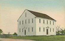
Once part of Kingston, Sandown was incorporated as a separate town in 1756 by Colonial Governor Benning Wentworth. It was named for picturesque Sandown on the Isle of Wight. The first minister of Sandown, the Reverend Josiah Cotton, built the Sandown Meeting House in 1774. It had an 11-foot-high (3.4 m) pulpit and marble columns supporting the gallery, and is still an excellent example of early New England church architecture.
Geography
According to the United States Census Bureau, the town has a total area of 14.4 square miles (37.3 km2), of which 13.9 sq mi (36.0 km2) is land and 0.5 sq mi (1.3 km2) is water, comprising 3.54% of the town. Sandown is primarily drained by the Exeter River; Phillips Pond, south of the center of town, drains north to the Exeter. Showell Pond, a smaller water body, drains northwest to Phillips Pond. Angle Pond, in the southeast corner of the town, and Cub Pond, along Sandown's eastern border, drain east towards the Powwow River. The highest point in Sandown is the summit of Hoyt Hill, at 505 feet (154 m) above sea level, near the town's southwest corner.
Demographics
| Historical population | |||
|---|---|---|---|
| Census | Pop. | %± | |
| 1790 | 561 | — | |
| 1800 | 501 | −10.7% | |
| 1810 | 504 | 0.6% | |
| 1820 | 527 | 4.6% | |
| 1830 | 553 | 4.9% | |
| 1840 | 525 | −5.1% | |
| 1850 | 566 | 7.8% | |
| 1860 | 553 | −2.3% | |
| 1870 | 496 | −10.3% | |
| 1880 | 500 | 0.8% | |
| 1890 | 475 | −5.0% | |
| 1900 | 400 | −15.8% | |
| 1910 | 380 | −5.0% | |
| 1920 | 280 | −26.3% | |
| 1930 | 229 | −18.2% | |
| 1940 | 292 | 27.5% | |
| 1950 | 315 | 7.9% | |
| 1960 | 366 | 16.2% | |
| 1970 | 741 | 102.5% | |
| 1980 | 2,057 | 177.6% | |
| 1990 | 4,060 | 97.4% | |
| 2000 | 5,143 | 26.7% | |
| 2010 | 5,986 | 16.4% | |
| Est. 2015 | 6,283 | [2] | 5.0% |
| U.S. Decennial Census[3] | |||
As of the census[4] of 2000, there were 5,143 people, 1,694 households, and 1,382 families residing in the town. The population density was 369.8 people per square mile (142.8/km²). There were 1,777 housing units at an average density of 127.8 per square mile (49.3/km²). The racial makeup of the town was 98.43% White, 0.21% African American, 0.12% Native American, 0.16% Asian, 0.02% Pacific Islander, 0.37% from other races, and 0.70% from two or more races. Hispanic or Latino of any race were 0.56% of the population.
There were 1,694 households out of which 48.7% had children under the age of 18 living with them, 71.0% were married couples living together, 6.8% had a female householder with no husband present, and 18.4% were non-families. 12.9% of all households were made up of individuals and 3.1% had someone living alone who was 65 years of age or older. The average household size was 3.02 and the average family size was 3.32.
In the town, the population was spread out with 31.4% under the age of 18, 5.4% from 18 to 24, 37.1% from 25 to 44, 20.7% from 45 to 64, and 5.3% who were 65 years of age or older. The median age was 35 years. For every 100 females, there were 105.1 males. For every 100 females age 18 and over, there were 100.5 males.
The median income for a household in the town was $67,581, and the median income for a family was $73,083. Males had a median income of $49,012 versus $29,773 for females. The per capita income for the town was $25,978. About 3.3% of families and 4.1% of the population were below the poverty line, including 2.8% of those under age 18 and 9.2% of those age 65 or over.
Education
- Timberlane Regional High School, Grades 9-12, located in Plaistow
- Timberlane Regional Middle School, Grades 6-8, located in Plaistow
- Sandown North Elementary School, Grades 1-5, located in Sandown
- Sandown Central School, Grades Pre-K, located in Sandown
Sites of interest
References
- ↑ United States Census Bureau, American FactFinder, 2010 Census figures. Retrieved March 23, 2011.
- ↑ "Annual Estimates of the Resident Population for Incorporated Places: April 1, 2010 to July 1, 2015". Archived from the original on June 2, 2016. Retrieved July 2, 2016.
- ↑ "Census of Population and Housing". Census.gov. Retrieved June 4, 2016.
- ↑ "American FactFinder". United States Census Bureau. Retrieved 2008-01-31.
External links
- Town of Sandown official website
- Tri-Town Times, community news
- Sandown Public Library
- New Hampshire Economic and Labor Market Information Bureau Profile
- Sandownweather.com
Places adjacent to Sandown, New Hampshire | |
|---|---|