Gustaf III Airport
| Rémy de Haenen Airport Gustaf III Airport Saint Barthélemy Airport St. Jean Airport Aérodrome de St Jean | |||||||||||
|---|---|---|---|---|---|---|---|---|---|---|---|
 | |||||||||||
| Summary | |||||||||||
| Airport type | Public | ||||||||||
| Operator | Mairie de St Barthélemy | ||||||||||
| Serves | Saint Barthélemy | ||||||||||
| Location | St. Jean | ||||||||||
| Hub for | Tradewind Aviation | ||||||||||
| Elevation AMSL | 48 ft / 15 m | ||||||||||
| Coordinates | 17°54′16″N 062°50′38″W / 17.90444°N 62.84389°WCoordinates: 17°54′16″N 062°50′38″W / 17.90444°N 62.84389°W | ||||||||||
| Map | |||||||||||
 SBH Location of airport in Saint Barthélemy | |||||||||||
| Runways | |||||||||||
| |||||||||||
|
Source: French AIP[1] | |||||||||||

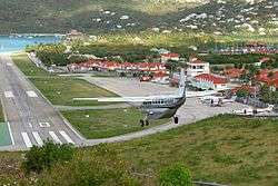
Gustaf III Airport[2] (IATA: SBH[2], ICAO: TFFJ[1]), also known as Saint Barthélemy Airport, Rémy de Haenen Airport, sometimes as St. Jean Airport (French: Aérodrome de St Jean[1]), is a public use airport located in the village of St. Jean on the Caribbean island of Saint Barthélemy.
Overview
Both the airport and the island's main town of Gustavia are named for King Gustav III of Sweden, under whom Sweden obtained the island from France in 1784 (it was sold back to France in 1878). In 1984, Swedish Minister of Communications, Hans Gustafsson, inaugurated the terminal building of the Gustaf III Airport. In 2015 the airport got the name Aéroport de Saint-Barthélemy-Rémy-de-Haenen, named after Rémy de Haenen, an aviation pioneer and later mayor of Saint Barthélemy.[3]
The airport is served by small regional commercial aircraft and charters. Most visiting aircraft carry fewer than twenty passengers, such as the Twin Otter, a common sight throughout the northern West Indies and as a curiosity, the Canadian-built de Havilland Dash 7 is the largest aircraft ever allowed to operate at this airport. The short airstrip is at the base of a gentle slope ending directly on the beach. The arrival descent is extremely steep over the hilltop traffic circle; departing planes fly right over the heads of sunbathers (although small signs advise sunbathers not to lie directly at the end of the runway). The airport is located at the island's second-largest town, St. Jean.
The History Channel programme Most Extreme Airports ranks Gustaf III airport, which is casually referred to as "St. Barth's", as the third most dangerous airport in the world.[4] This YouTube video of a tourist almost hit by a Cessna 172 highlights the close confines of airport and traffic.
Airlines and destinations
Passenger
| Airlines | Destinations |
|---|---|
| Air Antilles | Pointe-à-Pitre |
| Anguilla Air Services | Anguilla |
| Coastal Air | Charter: Saint Croix |
| FlyMontserrat | Charter: Montserrat |
| St Barth Commuter | Antigua, Sint Maarten, Saint Martin Charter: Antigua, Baillif, Barbados, Barbuda, Canouan, Dominica, Dominica-Canefield, Fort-de-France, La Romana, Mustique, Nevis, Pointe-à-Pitre, Providenciales, Puerto Plata, Punta Cana, Saint Croix, Saint-François, Saint Kitts, Saint Lucia-George F. L. Charles, Saint Lucia-Hewanorra, Saint Martin, Saint Thomas, Saint Vincent, San Juan, Santo Domingo-Las Américas, Sint Eustatius, Sint Maarten |
| Tradewind Aviation | Antigua, Nevis, Saint Thomas, San Juan Charter: Antigua, San Juan, St. Thomas |
| Trans Anguilla Airways | Anguilla |
| Winair | Antigua, Sint Maarten, Saba |
Cargo
| Airlines | Destinations |
|---|---|
| DHL Aviation | Anguilla, Antigua, Dominica-Canefield(to resume), Fort-de-France, Grenada, Nevis, Pointe-à-Pitre, Saint Croix, Saint Kitts, Saint Lucia, Saint Thomas, Saint Vincent, San Juan, Sint Maarten, Tortola, Trinidad |
References
- 1 2 3 TFFJ – Saint Barthélemy. AIP from French Service d'information aéronautique, effective 11 October 2018.
- 1 2 Great Circle Mapper – Gustaf III Airport (SBH / TFFJ)
- ↑ Aéroport Rémy de Haenen. St Barthélemy FWI
- ↑ Most Extreme Airports; The History Channel; 26 August 2010
External links
![]()