Bergerac Dordogne Périgord Airport
| Bergerac Dordogne Périgord Airport Aéroport de Bergerac Dordogne Périgord | |||||||||||||||
|---|---|---|---|---|---|---|---|---|---|---|---|---|---|---|---|
 | |||||||||||||||
| Summary | |||||||||||||||
| Airport type | Private, Seasonal Public | ||||||||||||||
| Operator | CCI de Dordogne | ||||||||||||||
| Serves | Bergerac, Dordogne, France | ||||||||||||||
| Elevation AMSL | 171 ft / 52 m | ||||||||||||||
| Coordinates | 44°49′28″N 00°31′14″E / 44.82444°N 0.52056°ECoordinates: 44°49′28″N 00°31′14″E / 44.82444°N 0.52056°E | ||||||||||||||
| Website |
www | ||||||||||||||
| Map | |||||||||||||||
 LFBE Location of airport in Nouvelle-Aquitaine region | |||||||||||||||
| Runways | |||||||||||||||
| |||||||||||||||
| Statistics (2014) | |||||||||||||||
| |||||||||||||||
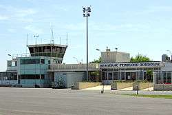
Bergerac Dordogne Périgord Airport (French: Aéroport de Bergerac Dordogne Périgord) (IATA: EGC, ICAO: LFBE) is an airport serving Bergerac, a commune of the Dordogne department (formerly the Périgord province) in the Nouvelle-Aquitaine region of France. The airport is located 3 kilometres (1.6 NM) south-southeast of Bergerac.[1][2] It is also known as Bergerac-Roumanière Airport.[1]
Facilities
The airport is situated at an elevation of 52 metres (171 ft) above mean sea level. It has one paved runway designated 10/28 which measures 2,205 by 45 metres (7,234 ft × 148 ft). It also has a parallel unpaved runway with a grass surface measuring 770 by 60 metres (2,526 ft × 197 ft).[1]
Airlines and destinations
| Airlines | Destinations |
|---|---|
| British Airways | Seasonal: London-City |
| Flybe | Southampton Seasonal: Birmingham, Edinburgh, Exeter |
| Jet2.com | Seasonal: Birmingham (begins 25 May 2019), Leeds/Bradford, Manchester [5] |
| Ryanair | London-Stansted Seasonal: Bristol, Charleroi, East Midlands, Liverpool |
| Transavia | Seasonal Rotterdam |
References
- 1 2 3 4 LFBE – Bergerac Roumanière. AIP from French Service d'information aéronautique, effective 11 October 2018.
- 1 2 (in French) Aéroport de Bergerac Dordogne Périgord (EGC / LFBE) Archived 2 February 2010 at the Wayback Machine. at Union des Aéroports Français
- ↑ Airport information for LFBE from DAFIF (effective October 2006)
- ↑ Airport information for EGC at Great Circle Mapper. Source: DAFIF (effective October 2006).
- ↑ http://www.manchesterairport.co.uk/flight-information/new-routes/
External links
![]()
This article is issued from
Wikipedia.
The text is licensed under Creative Commons - Attribution - Sharealike.
Additional terms may apply for the media files.