Gustavia, Saint Barthélemy
| Gustavia | |
|---|---|
| Quartier and town | |
| City of Gustavia | |
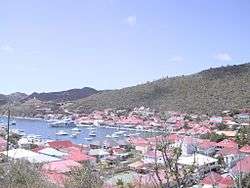 View over Gustavia | |
 | |
| Coordinates: 17°53′52.47″N 62°51′2.0″W / 17.8979083°N 62.850556°W | |
| Country | France |
| Overseas collectivity | Saint Barthélemy |
| Founded | 1785 |
| Government | |
| • Overseas Colectivity of Saint Barthélemy President (Territorial Council Pres.) | Bruno Magras |
| Area | |
| • Total | 3.4 km2 (1.3 sq mi) |
| Population | |
| • Total | 2,300 |
| Time zone | Atlantic |
 Gustavia Lighthouse in 2007 | |
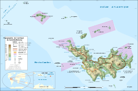
 Saint Barthélemy | |
| Location |
Gustavia Saint Barthélemy France |
|---|---|
| Coordinates | 17°54′03.8″N 62°51′05.0″W / 17.901056°N 62.851389°W |
| Year first constructed | 1961 |
| Construction | concrete tower |
| Tower shape | cone frustun tower with light |
| Markings / pattern | white tower with a red band on the top |
| Height | 10 metres (33 ft) |
| Focal height | 64 metres (210 ft) |
| Light source | mains power |
| Range |
white: 11 kilometres (6.8 mi) red: 8 kilometres (5.0 mi) green: 8 kilometres (5.0 mi) |
| Characteristic | Fl (3) WRG 12s. |
| Admiralty number | J5664 |
| NGA number | 14736 |
| ARLHS number | STM-002[1][2] |
Gustavia is the main town and capital of the island of Saint Barthélemy. Originally called Le Carénage, it was renamed in honor of King Gustav III of Sweden. Its sister city is Piteå, located in Norrbotten, Sweden.
History
Saint Barthélemy was first claimed by France, in 1648. The island was given to Sweden in exchange for trade rights in Gothenburg in 1784 and Sweden founded the Swedish West India Company. Prospering during the Napoleonic Wars, assets were low thereafter, and the island was sold back to France in 1878.
The eventual site of Gustavia was first called Le Carénage (The Careening) after the shelter it provided to damaged ships. According to the archives the name Gustavia appeared between December 28, 1786 and February 9, 1787. Gustavia remains as a reflection of the Swedish period.
Three forts built in the mid- to late 17th century protected the harbour: Oscar (formerly Gustav Adolf), Karl and Gustav. The Saint-Bartholomew Anglican Church on the harbourfront was built in 1855.
Amenities
The sites of Fort Karl, overlooking Shell Beach south of town, and Fort Gustav, at the base of the lighthouse to the north, are popular with hikers. Fort Oscar, at the tip of Gustavia Peninsula, houses the Gendarmerie. There is a museum at the end of Victor Schoelcher Road on the peninsula. Gustavia has a few restaurants serving American, Italian, French and other types of food. Gustavia has many high-end boutiques that are an essential source of revenue for the island, and one of the most high class luxury hotels on the island. There is a Royal Swedish Consulate at Gustavia (Consul Dantes Magras).
Climate
The climate is a tropical one with only minor variations in temperature. The island’s small surface area of 24 square kilometres (9 sq mi) allows it to take advantage of the smooth and pleasant blow of trade winds. Average water and air temperatures move around 27 °C (81 °F), and the year is divided into two seasons: a dry one, referred to as Lent (Careme), and a more humid one in summer. This latter season sets in between May and November, and the ever-present sun is overcast by short passages of rainclouds with brief showers of 10 to 15 minutes. According to the Köppen Climate Classification system Gustavia has a tropical monsoon climate, abbreviated "Am" on climate maps.[3]
| Climate data for Gustavia (1981–2010 averages, extremes 1959–present) | |||||||||||||
|---|---|---|---|---|---|---|---|---|---|---|---|---|---|
| Month | Jan | Feb | Mar | Apr | May | Jun | Jul | Aug | Sep | Oct | Nov | Dec | Year |
| Record high °C (°F) | 32.6 (90.7) |
32.4 (90.3) |
33.7 (92.7) |
33.2 (91.8) |
34.3 (93.7) |
34.2 (93.6) |
34.3 (93.7) |
34.8 (94.6) |
35.1 (95.2) |
35.5 (95.9) |
33.9 (93) |
32.7 (90.9) |
35.5 (95.9) |
| Average high °C (°F) | 28.4 (83.1) |
28.4 (83.1) |
29.0 (84.2) |
29.8 (85.6) |
30.7 (87.3) |
31.2 (88.2) |
31.1 (88) |
31.5 (88.7) |
31.6 (88.9) |
31.2 (88.2) |
29.7 (85.5) |
28.7 (83.7) |
30.1 (86.2) |
| Daily mean °C (°F) | 25.8 (78.4) |
25.7 (78.3) |
26.1 (79) |
26.9 (80.4) |
27.8 (82) |
28.4 (83.1) |
28.5 (83.3) |
28.7 (83.7) |
28.7 (83.7) |
28.3 (82.9) |
27.2 (81) |
26.2 (79.2) |
27.4 (81.3) |
| Average low °C (°F) | 23.2 (73.8) |
22.9 (73.2) |
23.2 (73.8) |
23.9 (75) |
24.9 (76.8) |
25.7 (78.3) |
25.8 (78.4) |
26.0 (78.8) |
25.9 (78.6) |
25.4 (77.7) |
24.6 (76.3) |
23.8 (74.8) |
24.6 (76.3) |
| Record low °C (°F) | 19.5 (67.1) |
18.5 (65.3) |
19.5 (67.1) |
19.8 (67.6) |
19.0 (66.2) |
21.4 (70.5) |
20.6 (69.1) |
21.1 (70) |
21.4 (70.5) |
20.6 (69.1) |
20.2 (68.4) |
19.1 (66.4) |
18.5 (65.3) |
| Average precipitation mm (inches) | 52.8 (2.079) |
46.5 (1.831) |
48.9 (1.925) |
62.4 (2.457) |
78.0 (3.071) |
55.6 (2.189) |
74.1 (2.917) |
88.4 (3.48) |
100.5 (3.957) |
136.3 (5.366) |
127.9 (5.035) |
87.6 (3.449) |
959.0 (37.756) |
| Average precipitation days (≥ 1.0 mm) | 11.6 | 9.5 | 8.2 | 7.8 | 10.1 | 9.0 | 12.0 | 12.6 | 11.4 | 12.1 | 13.5 | 12.9 | 130.6 |
| Source: Météo France[4] | |||||||||||||
Economy
The official currency of Saint Barthélemy is the euro.
Education
The town's public preschools and primary schools, under the authority of the Académie de la Guadeloupe, are:[5]
- Ecole primaire Gustavia
- Ecole maternelle Gustavia
Notable people
Eugénie Blanchard — the oldest verified person in the world at the time of her death. She spent most of her life in Gustavia.
Gallery
 Gustavia
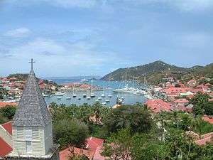 View of Gustavia
See also
References
- ↑ Gustavia The Lighthouse Directory. University of North Carolina at Chapel Hill. Retrieved 30 August 2016
- ↑ List of Lights, Buoys and Fog Signals Atlantic Coast. Retrieved 30 August 2016
- ↑ "Gustavia, Saint Barthélemy Köppen Climate Classification". Weatherbase.com. Retrieved 2015-06-19.
- ↑ "St–Barthelemy Meteo (971)" (PDF). Fiche Climatologique: Statistiques 1981–2010 et records (in French). Meteo France. Archived from the original (PDF) on 29 March 2018. Retrieved 29 March 2018.
- ↑ "LISTE DES ECOLES PUBLIQUES ET PRIVEES SOUS CONTRAT." Académie de la Guadeloupe. Retrieved on 10 March 2018.
External links
| Wikisource has the text of the 1905 New International Encyclopedia article Gustavia. |
- Government
- Collectivity of Saint Barthélemy (Official government website) (in French)
- Comité Territorial du Tourisme (Tourism board website) (in French)
- Gustavia Harbor/Port de Gustavia (Official website) (in French)
- General information
- "Saint Barthelemy". The World Factbook. Central Intelligence Agency.

| Wikimedia Commons has media related to Gustavia (Saint-Barthélemy). |
Coordinates: 17°53′52.47″N 62°51′2.0″W / 17.8979083°N 62.850556°W