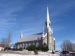
Saint-Raphaël, Quebec
| Saint-Raphaël | |
|---|---|
| Municipality | |
 | |
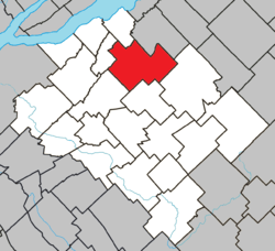 Location within Bellechasse RCM. | |
 Saint-Raphaël Location in province of Quebec. | |
| Coordinates: 46°48′N 70°45′W / 46.800°N 70.750°WCoordinates: 46°48′N 70°45′W / 46.800°N 70.750°W[1] | |
| Country |
|
| Province |
|
| Region | Chaudière-Appalaches |
| RCM | Bellechasse |
| Constituted | December 8, 1993 |
| Government[2] | |
| • Mayor | Gilles Breton |
| • Federal riding | Lévis—Bellechasse |
| • Prov. riding | Bellechasse |
| Area[2][3] | |
| • Total | 123.30 km2 (47.61 sq mi) |
| • Land | 121.55 km2 (46.93 sq mi) |
| Population (2011)[3] | |
| • Total | 2,463 |
| • Density | 20.3/km2 (53/sq mi) |
| • Pop 2006-2011 |
|
| • Dwellings | 1,214 |
| Time zone | UTC−5 (EST) |
| • Summer (DST) | UTC−4 (EDT) |
| Postal code(s) | G0R 4C0 |
| Area code(s) | 418 and 581 |
| Highways |
|
| Website |
www.municipalite. saint-raphael.qc.ca |
Saint-Raphaël is a municipality of about 2,400 people in Bellechasse Regional County Municipality in the Chaudière-Appalaches administrative region of Quebec. It has several small buildings and a very small supermarket.
References
Places adjacent to Saint-Raphaël, Quebec | |
|---|---|
| Municipalities | |
|---|---|
| Parishes | |
| |
This article is issued from
Wikipedia.
The text is licensed under Creative Commons - Attribution - Sharealike.
Additional terms may apply for the media files.