La Durantaye, Quebec
| La Durantaye | |
|---|---|
| Parish municipality | |
 | |
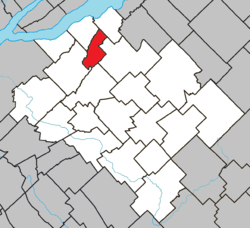 Location within Bellechasse RCM. | |
 La Durantaye Location in province of Quebec. | |
| Coordinates: 46°50′N 70°51′W / 46.833°N 70.850°WCoordinates: 46°50′N 70°51′W / 46.833°N 70.850°W[1] | |
| Country |
|
| Province |
|
| Region | Chaudière-Appalaches |
| RCM | Bellechasse |
| Constituted | August 4, 1910 |
| Named for | Olivier Morel de La Durantaye[1] |
| Government[2] | |
| • Mayor | Jean-Paul Lacroix |
| • Federal riding | Lévis—Bellechasse |
| • Prov. riding | Bellechasse |
| Area[2][3] | |
| • Total | 34.30 km2 (13.24 sq mi) |
| • Land | 34.82 km2 (13.44 sq mi) |
|
There is an apparent contradiction between two authoritative sources | |
| Population (2011)[3] | |
| • Total | 722 |
| • Density | 20.7/km2 (54/sq mi) |
| • Pop 2006-2011 |
|
| • Dwellings | 355 |
| Time zone | UTC−5 (EST) |
| • Summer (DST) | UTC−4 (EDT) |
| Postal code(s) | G0R 1W0 |
| Area code(s) | 418 and 581 |
| Highways |
|
| Website |
www |
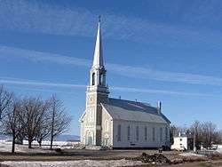
La Durantaye is a parish municipality in the Bellechasse Regional County Municipality in the Chaudière-Appalaches administrative region of Quebec.
The municipality had a population of 722 in the Canada 2011 Census.
References
Places adjacent to La Durantaye, Quebec | |
|---|---|
| Municipalities | |
|---|---|
| Parishes | |
| |
This article is issued from
Wikipedia.
The text is licensed under Creative Commons - Attribution - Sharealike.
Additional terms may apply for the media files.