Saint-Anselme, Quebec
| Saint-Anselme | |
|---|---|
| Municipality | |
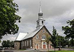 Saint-Anselme Church | |
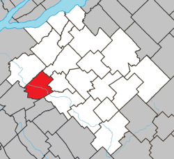 Location within Bellechasse RCM. | |
 Saint-Anselme Location in province of Quebec. | |
| Coordinates: 46°38′N 70°58′W / 46.633°N 70.967°WCoordinates: 46°38′N 70°58′W / 46.633°N 70.967°W[1] | |
| Country |
|
| Province |
|
| Region | Chaudière-Appalaches |
| RCM | Bellechasse |
| Constituted | January 7, 1998 |
| Government[2] | |
| • Mayor | Michel Bonneau |
| • Federal riding | Bellechasse—Les Etchemins—Lévis |
| • Prov. riding | Bellechasse |
| Area[2][3] | |
| • Total | 74.90 km2 (28.92 sq mi) |
| • Land | 73.77 km2 (28.48 sq mi) |
| Population (2011)[3] | |
| • Total | 3,458 |
| • Density | 46.9/km2 (121/sq mi) |
| • Pop 2006-2011 |
|
| • Dwellings | 1,421 |
| Time zone | UTC−5 (EST) |
| • Summer (DST) | UTC−4 (EDT) |
| Postal code(s) | G0R 2N0 |
| Area code(s) | 418 and 581 |
| Highways |
|
| Website |
www |
Saint-Anselme is a village in the Bellechasse Regional County Municipality, part of the Chaudière-Appalaches administrative region. It is the second biggest municipality in the RCM, after Saint-Henri. The Etchemin River goes through the village.
Personalities
- Georges Dumont (Saint-Anselme, 1898 - Moncton, 1966), medical doctor and politician
- Louis-Napoléon Larochelle (1834-1890), manufacturer, railway contractor and politician
References
Places adjacent to Saint-Anselme, Quebec | ||||||||||
|---|---|---|---|---|---|---|---|---|---|---|
| ||||||||||
| Municipalities | |
|---|---|
| Parishes | |
| |
This article is issued from
Wikipedia.
The text is licensed under Creative Commons - Attribution - Sharealike.
Additional terms may apply for the media files.