Saint-Prosper, Chaudière-Appalaches, Quebec
- For the former Saint-Prosper in Mauricie, see Saint-Prosper-de-Champlain, Quebec.
| Saint-Prosper | |
|---|---|
| Municipality | |
 | |
_Quebec_location_diagram.png) Location within Les Etchemins RCM | |
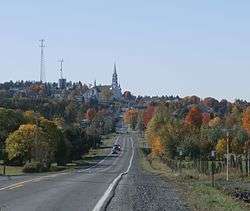
 Saint-Prosper Location in southern Quebec | |
| Coordinates: 46°13′N 70°29′W / 46.217°N 70.483°WCoordinates: 46°13′N 70°29′W / 46.217°N 70.483°W[1] | |
| Country |
|
| Province |
|
| Region | Chaudière-Appalaches |
| RCM | Les Etchemins |
| Constituted | September 26, 1887 |
| Government[2] | |
| • Mayor | Richard Couët |
| • Federal riding | Beauce |
| • Prov. riding | Beauce-Sud |
| Area[2][3] | |
| • Total | 134.10 km2 (51.78 sq mi) |
| • Land | 133.66 km2 (51.61 sq mi) |
| Population (2011)[3] | |
| • Total | 3,605 |
| • Density | 27.0/km2 (70/sq mi) |
| • Pop 2006-2011 |
|
| • Dwellings | 1,547 |
| Time zone | UTC−5 (EST) |
| • Summer (DST) | UTC−4 (EDT) |
| Postal code(s) | G0M 1Y0 |
| Area code(s) | 418 and 581 |
| Highways |
|
| Website |
www |
Saint-Prosper is a municipality in Les Etchemins Regional County Municipality in Quebec, Canada. It is part of the Chaudière-Appalaches region and the population is 3,617 as of 2009. It is named after Reverend Prosper-Marcel Meunier, first priest of the parish. It is sometimes known as Saint-Prosper-de-Dorchester.
People linked to Saint-Prosper
- Fabien Roy, Canadian politician
References
- Commission de toponymie du Québec
- Ministère des Affaires municipales, des Régions et de l'Occupation du territoire
| Wikimedia Commons has media related to Saint-Prosper, Chaudière-Appalaches, Quebec. |
Places adjacent to Saint-Prosper, Chaudière-Appalaches, Quebec | |
|---|---|
| Municipalities | |
|---|---|
| Parishes | |
| |
This article is issued from
Wikipedia.
The text is licensed under Creative Commons - Attribution - Sharealike.
Additional terms may apply for the media files.