Saddle Island, South Georgia
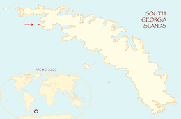 Location of Saddle Island in South Georgia Islands | |
| Geography | |
|---|---|
| Coordinates | 54°08′25″S 37°44′57″W / 54.14028°S 37.74917°WCoordinates: 54°08′25″S 37°44′57″W / 54.14028°S 37.74917°W |
| Archipelago | South Georgia Islands |
| Length | 1.98 km (1.23 mi) |
| Width | 0.98 km (0.609 mi) |
| Administration | |
|
United Kingdom | |
| Demographics | |
| Population | 0 |
Saddle Island is 1.98 km (1.23 mi) long and 980 metres (1,070 yd) wide,[1] situated on the south side of the entrance to Wilson Harbour on the west coast of South Georgia Island in the Antarctic. The island is separated from the mainland of South Georgia by a 280 metres (310 yd) wide passage.[1]
Location
Saddle Island is located at 54°08′25″S 37°44′57″W / 54.14028°S 37.74917°W which is 18.9 km (11.7 mi) southeast of Cape Paryadin, 29.1 km (18.1 mi) west of Peggotty Bluff and 26.3 km (16.3 mi) northwest of Cape Nuñez.[1]
See also
Map
- South Georgia. Scale 1:200000 topographic map. DOS 610 Series. Directorate of Overseas Surveys, Tolworth, UK, 1958.
References
- 1 2 3 Distances measured by Google Earth.
External links
- Saddle Island. Agreement on the Conservation of Albatrosses and Petrels: Data Portal.
- J.P. Croxall. Distribution and population changes in the wandering albatross Diomedea Exulans at South Georgia. British Antarctic Survey, 1979.
Capital: King Edward Point | |
| General | |
| Settlements / Whaling stations | |
| South Georgia islands | |
| South Sandwich islands | |
| Landmarks |
|
This article is issued from
Wikipedia.
The text is licensed under Creative Commons - Attribution - Sharealike.
Additional terms may apply for the media files.