Bay of Isles
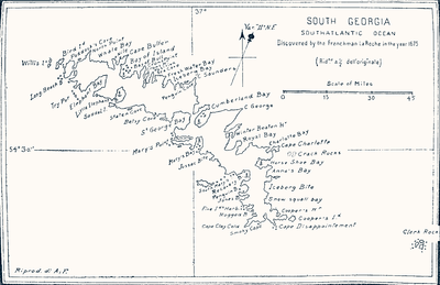
The Bay of Isles is a bay 9 miles (14 km) wide and receding 3 miles (5 km), lying between Cape Buller and Cape Wilson along the north coast of South Georgia. It was discovered in 1775 by a British expedition under James Cook and so named by him because numerous islands (at least twelve) lie in the bay.[1] Many of these islands are named after local birds, including:
- Albatross Island (albatross)
- Crescent Island
- Invisible Island
- Mollyhawk Island (mollyhawk)
- Skua Island (skua)
- Petrel Island (petrel)
- Prion Island (prion)
- Tern Island (tern)
The area, along with Grytviken, is one of two Areas of Special Tourist Interest on the island. Of South Georgia's 31 breeding bird species, 17 are found here.
Rosita Harbour is on the west coast of the bay.
References
- ↑ "Isles, Bay of". Geographic Names Information System. United States Geological Survey. Retrieved 2012-07-11.
- Stonehouse, B (ed.) Encyclopedia of Antarctica and the Southern Oceans (2002, ISBN 0-471-98665-8)
![]()
Coordinates: 54°2′S 37°20′W / 54.033°S 37.333°W
Capital: King Edward Point (Grytviken) | |
| General | |
| Settlements / Whaling stations | |
| South Georgia islands | |
| South Sandwich islands | |
| Landmarks |
|