Mount Paget
| Mount Paget | |
|---|---|
 Mount Paget | |
| Highest point | |
| Elevation | 2,935 m (9,629 ft) [1] |
| Prominence |
2,935 m (9,629 ft) Ranked 101st |
| Isolation | 2,267 kilometres (1,409 mi) |
| Listing | Ultra |
| Coordinates | 54°26′S 36°33′W / 54.433°S 36.550°WCoordinates: 54°26′S 36°33′W / 54.433°S 36.550°W |
| Geography | |
 Location of Mt. Paget
| |
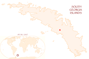
| Location | South Georgia |
| Parent range | Allardyce Range |
| Climbing | |
| First ascent | Combined Services Expedition (British military) led by Commander Malcolm Burley, 30 December 1964 |
| Easiest route | snow/ice climb |
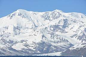
Mount Paget is a summit of Allardyce Range on the South Atlantic/Antarctic island of South Georgia. It is the highest peak on the island, and also the highest peak in any territory under the sovereignty of the United Kingdom (except the British Antarctic Territory, that has no permanent population and where British sovereignty is unrecognized by most countries, where Mount Hope is the highest peak), twice the height of Ben Nevis, the highest mountain on the island of Great Britain.
It is a saddle-shaped mountain, marking the highest point of the Allardyce Range in the central part of South Georgia. This feature was known to early sealers and whalers at South Georgia, and the name has long been established through general usage.[1] It is clearly visible from Grytviken and King Edward Point.
References
- Stonehouse, B (ed.) Encyclopedia of Antarctica and the Southern Oceans (2002, ISBN 0-471-98665-8)
Capital: King Edward Point | |
| General | |
| Settlements / Whaling stations | |
| South Georgia islands | |
| South Sandwich islands | |
| Landmarks |
|