Sabarkantha district
| Sabarkantha district | |
|---|---|
| district | |
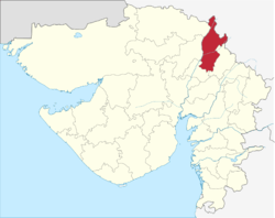 Location of district in Gujarat | |
| Country |
|
| State | Gujarat |
| Headquarters | Himatnagar |
| Languages | |
| • Official | Gujarati, Hindi, English |
| Time zone | UTC+5:30 (IST) |
| ISO 3166 code | GJ-IN |
| Vehicle registration | GJ-9 |
| Website |
gujaratindia |
Sabarkantha is a district in Northeast of Gujarat state of India.
Geography
Sabarkantha District is bounded by Rajasthan state to the north and northeast, Banaskantha district and Mehsana district to the west, Gandhinagar District to the south and Aravalli District to the South - East.
Himmatnagar is a district headquarters, and talukas Prantij and Talod are major industrial locations in Sabarkantha
Focus Industry Sectors – Agriculture, ceramics, chemicals and milk processing
Tourist Destinations – Idar, Polo Forests, Vijaynagar
Key raw materials such as groundnut, cotton, clay, oilseeds and tobacco are abundantly present in Sabarkantha.
The district comprises 7 Talukas. It is spread across an area of 7390 km2. It has a gender ratio of 950 females per 1000 men, and the literacy rate for the district is 76.6%.
It falls under Sesmic Zone 3
History
During the Western Satrap rule, the region was known as Shwabhra (Gujarati: શ્વભ્ર). The region is under rule of Satrap Rudradama in 150 A.D. as indicated in Ashoka's Major Rock Edicts at Junagadh. The river of the region is named as Shwabhravati which is now known as Sabarmati River. The region is also named in auxiliary text Gaṇapāṭha of Pāṇini's grammar work, Aṣṭādhyāyī.[1]
During the British Raj Vijaynagar in Sabarkantha district was the capital of Vijaynagar State or Pol State, one of the princely states of the Mahi Kantha Agency.[2]
Festivals
The Traditional Fair Chitra – VichitraMela
The fair is held a fortnight after Holi, around the month of March-April. It starts on the eve of the new moon (called Amavas), the time when the wheat crop is ready for harvest. Each year the Chitra Vichitra Fair plays itself out within the limits of the village Gunbhakhari in the border area of the Sabarkantha district adjoining Rajasthan, 32 km away from the nearest railway station of Khedbrahma. The main temple of the fair is situated on a picturesque site called the TriveniSangam, the sacred confluence of the three rivers Sabarmati, Akul and Vyakul, amid the foothills of the Aravalis. The name of the fair is derived from two brothers Chitravirya and Vichitravirya, sons of King Shantanu, and step brothers of Bhishma, from the story of the Mahabharata. There is a belief that they had settled here and were cured of their diseases by the waters of this site. The fair is one of the most important fairs of the Adivasis in the region, and attracts about 60,000 people, most of them hailing from the Garasia and Bhil communities. People from many far away and distant villages arrive here. The fair is so popular that in 25 to 30 surrounding villages all the houses are deserted for the duration of the fair as every able-bodied person visits it. This fair is also a great opportunity for tribal men to meet prospective partners for marriage. Numerous couples have been known to elope directly from the fair site.
Economy
In 2006 the Ministry of Panchayati Raj named Sabarkantha one of the country's 250 most backward districts (out of a total of 640).[3] It is one of the six districts in Gujarat currently receiving funds from the Backward Regions Grant Fund Programme (BRGF).[3]
Divisions
Sabarkantha district has following 8 Talukas :
- Himatnagar - District Headquarters
- Idar
- Prantij
- Talod
- Khedbrahma
- Vadali
- Vijaynagar
- Poshina
Demographics
According to the 2011 census Sabarkantha district has a population of 2,427,346,[4] roughly equal to the nation of Kuwait[5] or the US state of New Mexico.[6] This gives it a ranking of 183rd in India (out of a total of 640).[4] The district has a population density of 328 inhabitants per square kilometre (850/sq mi) .[4] Its population growth rate over the decade 2001-2011 was 16.56%.[4] Sabarkantha has a sex ratio of 950 females for every 1000 males,[4] and a literacy rate of 76.6%.[4]
Punsari, a small village in the district was selected as the best village in Gujarat.[7]
Culture
Communities in the districts
Major communities in Sabarkantha are traditional Hindu communities of Ahirs, Rabaris, Thakores and Harijans. The Ahirs are traditionally followers of Lord Krishna, supposed to have migrated from Northern India and settled here, this community has striking features and long cultural traditions. The main occupation of the communities is agriculture and cattle breeding. Source: https://www.datanetindia-ebooks.com/District_Factbook/Gujarat/Sabar_Kantha
Forts
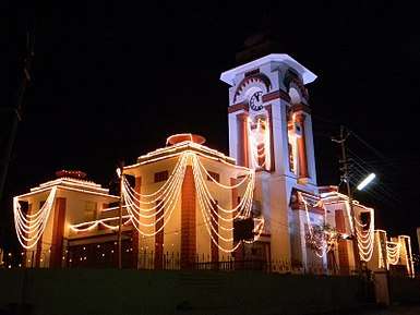
Idario Gadh - Ilva Durga (ancient fort) – Idar is an ancient fort, known as 'Ilva Durga' and finds mentioned in Mahabharat and in the travelogue of the Rathore Rajputs in the Mahi Kantha agency at the time of British Raj. It is a classic example of a naturally protected hill fort, located at the southern edge of the Aravalli range. At the foothill, lay the ruins of an old palace, a fine specimen of architecture in stone with delicately carved balconies. The entry to Idar town is through a three storeyed clock tower cum entrance gate, with a huge arch and semi circular dome at the top. The road, with a colourful bazaar on both sides, leads to the tower and ends at the foothills of Idar fort.[8]
Heritage Sites
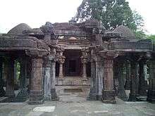
Vijay Villas Vijaynagar - Vijay Villas Vijaynagar is nested on the foothills of the aravali ranges and is on the edge of among the few dense forests left in Gujarat in the Sabarkantha district which is on the border of Gujarat and Rajasthan. It is a heaven for nature and wild life admirers. Unique for its picturesque surroundings which serves as a refuge for fascinating species of flora and fauna, a sanctuary of rare birds and wild animals, adorned by beautiful flowing rivulets and unsullied lakes fills up your senses.[9]
Darbargadh - About 18 km from Ambaji in Sabarkantha district, Poshina takes one back to the simple beauty of traditional village life, populated by a captivating mélange of colorful tribal communities of the Garasias, Bhils and the pastoral Rabaris. Poshina is home to a tribal shrine where you find the staggering scene of thousands of terracotta horses standing in rows as offerings to the local goddess. Nearby villages have similar horses carved in reverence to her divinity. A visit to the homes of the potters who make these striking horses is an excellent glimpse into tribal culture.
In Poshina you find the Darbargadh Poshina, once a palace, and now a welcoming heritage hotel, with huge gateways, a massive dome, numerous pillars and arches, a pleasant courtyard, gardens, lawns and terraces, owned by the descendants of the Chalukyas, whose empire spread through much of Gujarat and Central India in the 12th century. You also find old Jain sandstone temples of Parshvanath and Neminath and an old Shiva temple.
Poshina is host to the famous Chitra-Vichitra fair, at the nearby Gunbhakhari village, a couple of weeks after Holi.[10]
POLO MONUMENT AND VIJAYNAGAR FOREST
Notable personalities
- Umashankar Joshi (1911–1988) Writer and scholar. Born in Bamna.
See also
References
- ↑ Shukla, Jaykumar R. Shwabhra, Gujarati Vishwakosh, p. 754.
- ↑ Rajput Provinces of India - Vijaynagar State (Princely State)
- 1 2 Ministry of Panchayati Raj (September 8, 2009). "A Note on the Backward Regions Grant Fund Programme" (PDF). National Institute of Rural Development. Archived from the original (PDF) on April 5, 2012. Retrieved September 27, 2011.
- 1 2 3 4 5 6 "District Census 2011". Census2011.co.in. 2011. Retrieved 2011-09-30.
- ↑ US Directorate of Intelligence. "Country Comparison:Population". Retrieved 2011-10-01.
Kuwait 2,595,62
- ↑ "2010 Resident Population Data". U. S. Census Bureau. Retrieved 2011-09-30.
New Mexico - 2,059,179
- ↑ Bharat Yagnik (20 May 2012). "Gujarat village that puts metros to shame". The Times of India.
- ↑ http://gujaratindia.com/about-gujarat/forts-1.htm#Idar
- ↑ "Archived copy". Archived from the original on 2012-01-09. Retrieved 2014-03-22.
- ↑ "Archived copy". Archived from the original on 2014-03-22. Retrieved 2014-03-22.
External links
Places adjacent to Sabarkantha district | |
|---|---|
| Topics | 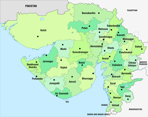 | |
|---|---|---|
| Regions of Gujarat | ||
| Districts | ||
| Major cities | ||
| Ecoregions | ||
| Economy |
| |
| ||