Rural Municipality of Springfield
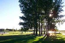
Springfield is a rural municipality in Manitoba, Canada. It stretches from urban industrial development on the eastern boundary of the City of Winnipeg, through urban, rural residential, agricultural and natural landscapes, to the Agassiz Provincial Forest on the municipality's eastern boundary.
Springfield was incorporated in 1880 as a result of changes made to the R.M. of Springfield and Sunnyside (1873–1880).[1] The municipality received its name due to the presence of multiple natural springs found within its borders.[1] Birds Hill Provincial Park nestles into the northwestern corner of Springfield. While farming is still important in the municipality, today many residents are employed in nearby Winnipeg. In the 2011 census the population was 14,069, up 8.3% from 2006.[2]
The Springfield provincial election district includes all of the municipality and parts of adjacent East St. Paul. From 1914 through 1966 a Federal riding was also called "Springfield" with varying boundaries not always coterminous with the municipality.[3]
Historic sites
The R.M. of Springfield contains many sites of historical and cultural significance such as the Sunnyside cemetery, the Springfield Hutterite colony, North Springfield school, Springfield Agricultural Society and others.[4] In 1996, the Ukrainian Catholic Church of the Immaculate Conception in Cooks Creek was designated a National Historic Site of Canada.
Centres in Springfield
Oakbank is the administrative centre of Springfield where the municipal council meets. Other communities include Dugald, Anola, Cooks Creek, Hazelridge and Glass.
Governance
As of 2015, the municipality was governed by a reeve and 5 ward councillors. The government has come under some scrutiny for having the highest compensation to mayor and council ($242,974 total for 2015) relative to all other municipalities in the Winnipeg capital region. [5]
References
- Rural Municipality of Springfield
- Community Profile: Springfield Rural Municipality, Manitoba; Statistics Canada
- 1 2 "Manitoba Municipalities: Springfield". Manitoba Historical Society. Manitoba Historical Society. Retrieved 17 October 2015.
- ↑ Canada, Government of Canada, Statistics. "Statistics Canada: 2011 Census Profile". www12.statcan.ca. Retrieved 22 April 2018.
- ↑ http://www.parl.gc.ca/About/Parliament/FederalRidingsHistory/hfer.asp?Include=Y&rid=697&Search=Det&Language=E Federal Riding History retrieved 2011 Sept 23
- ↑ "Search results for "Springfield"". Manitoba Historical Society. Manitoba Historical Society. Retrieved 17 October 2015.
- ↑ Bill Redekop (17 February 2015). "Salaries for municipal leaders in the capital region vary widely – Winnipeg Free Press". Winnipegfreepress.com. Retrieved October 29, 2015.
Further reading
- Aileen Kraushar et al., Springfield 1st Rural Municipality in Manitoba 1873-1973, Dugald Women's Institute, Dugald Manitoba Canada 1974, ISBN 0-919212-40-9
External links
| Wikimedia Commons has media related to Rural Municipality of Springfield. |
Places adjacent to Rural Municipality of Springfield | |
|---|---|
Coordinates: 49°55′45″N 96°41′38″W / 49.92917°N 96.69389°W
| Towns | 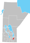 | |
|---|---|---|
| Rural municipalities | ||
| Unincorporated communities | ||