Deloraine, Manitoba
| Deloraine | |
|---|---|
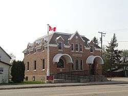 The post office in Deloraine, constructed 1930 | |
 Deloraine | |
| Coordinates: 49°11′27″N 100°29′38″W / 49.19083°N 100.49389°WCoordinates: 49°11′27″N 100°29′38″W / 49.19083°N 100.49389°W | |
| Country | Canada |
| Province | Manitoba |
| Village | March 1, 1904 |
| Town | May 1, 1907 |
| Amalgamation | January 1, 2015 |
| Area | |
| • Metro | 2.54 km2 (0.98 sq mi) |
| Population (2016) | |
| • City | 978 |
| • Density | 385.7/km2 (999/sq mi) |
| Time zone | UTC−5 (CST) |
| • Summer (DST) | UTC−6 (CDT) |
| Website | http://delowin.ca/ |
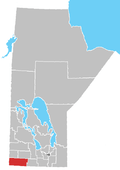
Deloraine is an unincorporated urban community in the Municipality of Deloraine – Winchester within the Canadian province of Manitoba that held town status prior to January 1, 2015. It is situated near the Turtle Mountains in the southwestern corner of the province. Located in the Westman Region, the community is 100 kilometres south of Brandon. Deloraine originally incorporated as a village in 1904 and then as a town in 1907. Its town status was relinquished in 2015 when it amalgamated with the Rural Municipality of Winchester.
History
Deloraine originally incorporated as a village on March 1, 1904. It then incorporated as a town on May 1, 1907. As part of Manitoba's municipal amalgamation initiative, the Town of Deloraine amalgamated with the Rural Municipality of Winchester on January 1, 2015 to become the Municipality of Deloraine – Winchester.[1]
- Artifacts from the Paleo Indians, dating back over 10,000 years ago, have been found in the Deloraine area.
- Several fur trading companies built forts and trading posts in the area and on the nearby Souris River.
Tourism

Tourism is a big part of Deloraine's economy. The tourist booth, located in the downtown area, is the starting point for many interesting outings and family journeys. Lakes in the local area offer recreational activities and fun for the whole family. The beauty of the surrounding countryside provides endless opportunity for country picnics and hiking in the summer, or cross-country skiing and snowmobiling in the winter. Fishing and hunting are also popular in season.
Attractions
- One of only two stone bank vaults still in existence in western Canada
- Only commercial coal mine in Manitoba's history. Now abandoned, it was used from the 1890[2] until the Great Depression
- A 1/2-mile harness race track hosts racing during the summer
- Nygard Park home to Flags of the World (Millennium project)
Climate
| Climate data for Deloraine | |||||||||||||
|---|---|---|---|---|---|---|---|---|---|---|---|---|---|
| Month | Jan | Feb | Mar | Apr | May | Jun | Jul | Aug | Sep | Oct | Nov | Dec | Year |
| Record high °C (°F) | 7.8 (46) |
16.5 (61.7) |
21.7 (71.1) |
35 (95) |
41.1 (106) |
37.5 (99.5) |
40.6 (105.1) |
38.5 (101.3) |
38.3 (100.9) |
32 (90) |
21.1 (70) |
16.1 (61) |
41.1 (106) |
| Average high °C (°F) | −9.7 (14.5) |
−6.7 (19.9) |
0.6 (33.1) |
11.2 (52.2) |
19.3 (66.7) |
23.5 (74.3) |
26.1 (79) |
25.4 (77.7) |
18.6 (65.5) |
11.5 (52.7) |
0.3 (32.5) |
−7.9 (17.8) |
9.3 (48.7) |
| Daily mean °C (°F) | −15.5 (4.1) |
−12.2 (10) |
−4.7 (23.5) |
4.9 (40.8) |
12.6 (54.7) |
17.1 (62.8) |
19.5 (67.1) |
18.5 (65.3) |
12.2 (54) |
5.4 (41.7) |
−4.5 (23.9) |
−13.2 (8.2) |
3.3 (37.9) |
| Average low °C (°F) | −21.3 (−6.3) |
−17.6 (0.3) |
−9.9 (14.2) |
−1.3 (29.7) |
5.8 (42.4) |
10.6 (51.1) |
12.8 (55) |
11.6 (52.9) |
5.7 (42.3) |
−0.9 (30.4) |
−9.2 (15.4) |
−18.5 (−1.3) |
−2.7 (27.1) |
| Record low °C (°F) | −43.3 (−45.9) |
−46.1 (−51) |
−39.4 (−38.9) |
−31.1 (−24) |
−10 (14) |
−3.3 (26.1) |
−1.1 (30) |
−3 (27) |
−7.8 (18) |
−21 (−6) |
−33.3 (−27.9) |
−41.5 (−42.7) |
−46.1 (−51) |
| Average precipitation mm (inches) | 19.6 (0.772) |
14.3 (0.563) |
24.4 (0.961) |
33.8 (1.331) |
49.9 (1.965) |
85.3 (3.358) |
67.4 (2.654) |
58.5 (2.303) |
51.2 (2.016) |
33.9 (1.335) |
20.6 (0.811) |
19.3 (0.76) |
478.1 (18.823) |
| Source: Environment Canada[3] | |||||||||||||
Notable people
- Birthplace of the Honourable Justice Ronald D. Bell.
- Once home to fashion designer Peter Nygård.
- Birthplace of Canadian former diplomat and ambassador to Yugoslavia, Albania and Bulgaria James Bissett
- Birthplace of tenor William Morton
References
- ↑ "Manitoba Municipalities: Deloraine". Manitoba Historical Society. December 24, 2015. Retrieved September 25, 2016.
- ↑ "Trade Sales". Hardware. 21 Feb 1890. Retrieved 19 April 2013.
- ↑ Environment Canada - Canadian Climate Normals 1971-2000—Canadian Climate Normals 1971–2000, accessed 13 April 2011
External links
| Wikimedia Commons has media related to Deloraine, Manitoba. |
Places adjacent to Deloraine, Manitoba | ||||||||||
|---|---|---|---|---|---|---|---|---|---|---|
| ||||||||||
Division No. 5, Manitoba (Southwest Manitoba) | ||||
|---|---|---|---|---|
| Towns |
|  | ||
| Villages |
| |||
| Rural municipalities |
| |||
| Unincorporated communities | ||||
| Subdivisions | |||
|---|---|---|---|
| Cities | |||
| Towns |
| ||
| Villages |
| ||
| |||