Rumbek Airport
| Rumbek Airport | |||||||||||
|---|---|---|---|---|---|---|---|---|---|---|---|
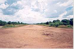 The runway in 2004 | |||||||||||
| Summary | |||||||||||
| Airport type | Public, Civilian | ||||||||||
| Owner | Civil Aviation Authority of South Sudan | ||||||||||
| Serves | Rumbek, South Sudan | ||||||||||
| Location |
Rumbek, | ||||||||||
| Elevation AMSL | 1,380 ft / 420 m | ||||||||||
| Coordinates | 6°50′N 29°40′E / 6.83°N 29.67°E | ||||||||||
| Map | |||||||||||
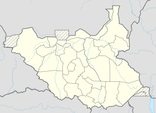 Rumbek Location of Rumbek Airport in South Sudan | |||||||||||
| Runways | |||||||||||
| |||||||||||
Rumbek Airport (IATA: RBX, ICAO: HSMK) is an airport in South Sudan, near Rumbek the capital of Western Lakes State. The airport is served by several national airlines and by air charter service providers.
Location
Rumbek Airport is located in Rumbek Central County, Western Lakes State, in central South Sudan, near the town of Rumbek. Its location lies approximately 302 kilometres (188 mi), by air, northwest of Juba International Airport, the largest airport in the country.[1] Rumbek Airport is located at an altitude of 420 metres (1,380 ft) above sea level.[2] The geogroaphical coordinates of this airport are: 6° 49' 48.00"N, 29° 40' 12.00"E (Latitude: 6.83000; Longitude: 29.6700).
Airlines and destinations
Service was provided to Juba, South Sudan by Southern Star Airlines until the airline ceased flying in 2011.
| Airlines | Destinations |
|---|---|
| Aircraft Leasing Services | Lokichogio, Nairobi-Wilson |
Accidents and incidents
- In March 2003, Hawker Siddeley Andover 3C-KKB of 748 Air Services was damaged beyond repair when it crashlanded at Rumbek following an engine failure.[3]
- On 2 May 2008, a Beechcraft 1900c operated by Southern Sudan Air Connection departed Wau (WUU) on a flight to Juba via Rumbek. The airplane was carrying a delegation of leaders from the Sudan People's Liberation Movement (SPLM). Passenger included Dominic Dim Deng, then Southern Sudan's Defense Minister. Near Rumbek both engines failed. The aircraft crashed, killing all on board.[4]
External links
References
- ↑ "Distance between Rumbek (Al Buhayrat) and Juba (Airport), Sudan". distancecalculator.globefeed.com. Retrieved 2018-08-24.
- ↑ allmetsat. "Climate: Rumbek, Sudan". en.allmetsat.com. Retrieved 2018-08-24.
- ↑ "3C-KKB Accident description". Aviation Safety Network. Retrieved 22 June 2010.
- ↑ Ranter, Harro. "ASN Aircraft accident Beechcraft 1900C 5Y-FLX Rumbek". aviation-safety.net. Retrieved 2018-08-24.