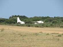
Kapoeta Airport
| Kapoeta Airport | |||||||||||
|---|---|---|---|---|---|---|---|---|---|---|---|
 | |||||||||||
| Summary | |||||||||||
| Airport type | Public, Civilian | ||||||||||
| Owner | Civil Aviation Authority of South Sudan | ||||||||||
| Serves | Kapoeta, South Sudan | ||||||||||
| Location |
Kapoeta, | ||||||||||
| Elevation AMSL | 2,221 ft / 677 m | ||||||||||
| Coordinates | 04°46′48″N 33°35′06″E / 4.78000°N 33.58500°E | ||||||||||
| Map | |||||||||||
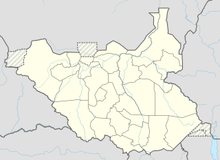 Kapoeta Location of Kapoeta Airport in South Sudan | |||||||||||
| Runways | |||||||||||
| |||||||||||
|
Sources:[1] | |||||||||||
Kapoeta Airport is an airport serving Kapoeta in South Sudan.
Location
Kapoeta Airport (IATA: n/a, ICAO: HSKP) is located in Kapoeta South County in Namorunyang State, in the town of Kapoeta, near the International borders with Kenya and Uganda. The airport is located approximately 3 kilometres (1.9 mi), north of the central business district of Kapoeta.
This location lies approximately 221 kilometres (137 mi), by air, east of Juba International Airport, South Sudan's largest airport.[2] The geographic coordinates of this airport are: 4° 46' 48.00"N, 33° 35' 6.00"E (Latitude: 4.7800; Longitude: 33.5850). Kapoeta Airport is situated 677 metres (2,221 ft) above sea level.[3] The airport has a single unpaved runway that is 1058 m. in length.
Overview
Kapoeta Airport is a small civilian and military airport that serves the town of Kapoeta and surrounding communities.
See also
References
- ↑ Airport information for HSKP from DAFIF (effective October 2006)
- ↑ "Distance between Kapoeta (Sharq al Istiwa'iyah) and Juba () (Airport) (Sudan)". distancecalculator.globefeed.com. Retrieved 2018-08-24.
- ↑ Kapoeta Elevation Is 2,220 Feet Above Sea Level Archived 2012-03-17 at the Wayback Machine.
External links
| Counties |  | |
|---|---|---|
| Principal towns | ||
| Airports | ||
| Rivers | ||
| Mountains | ||
| Communities | ||