Metropolitan Borough of Rotherham
| Borough of Rotherham | ||
|---|---|---|
| Metropolitan borough | ||
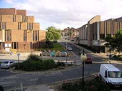 Former Rotherham Council Offices (left) in central Rotherham | ||
| ||
| Nickname(s): The Heart of SY | ||
| Motto(s): Where everyone matters | ||
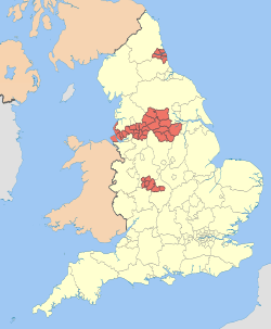
 Rotherham shown within South Yorkshire | ||
| Sovereign state | United Kingdom | |
| Constituent country | England | |
| Region | Yorkshire and the Humber | |
| Ceremonial county | South Yorkshire | |
| Founded | 1974 | |
| Admin. HQ | Rotherham | |
| Government | ||
| • Type | Rotherham Metropolitan Borough Council | |
| • Leadership: | Leader & Cabinet | |
| • Executive: | Labour | |
| • MPs: |
Kevin Barron, John Healey, Sarah Champion | |
| Area | ||
| • Total | 110.6 sq mi (286.5 km2) | |
| Area rank | 142nd | |
| Population (mid-2017 est.) | ||
| • Total | 263,400 | |
| • Rank | Ranked 56th | |
| • Density | 2,400/sq mi (920/km2) | |
| Time zone | UTC+0 (Greenwich Mean Time) | |
| • Summer (DST) | UTC+1 (British Summer Time) | |
| ONS code |
00CF (ONS) E08000018 (GSS) | |
| Ethnicity |
91.9% White British 4.1% Asian 0.8% Black[1] | |
| Website | rotherham.gov.uk | |
The Metropolitan Borough of Rotherham is a metropolitan borough of South Yorkshire, England. It is named after its largest town, Rotherham, but also spans the outlying towns of Maltby, Rawmarsh, Swinton, Wath-upon-Dearne, and also Dinnington and Laughton as well as a suburban and rural element composed of hills, escarpments and broad valleys.
The district was formed on 1 April 1974, under the Local Government Act 1972, as a merger of the County Borough of Rotherham, with Maltby, Rawmarsh, Swinton and Wath-upon-Dearne urban districts along with Rotherham Rural District and Kiveton Park Rural District.
Rotherham Metropolitan Borough Council is one of the safest Labour councils in the United Kingdom, although the number of Labour council seats dropped from 92% to 79% in 2014 following the Rotherham child sexual exploitation scandal.[2]
Geography
Settlements in the borough of Rotherham include:
- Anston, Aston, Aughton
- Bramley, Brampton, Brinsworth, Brecks, Broom
- Canklow, Catcliffe, Clifton
- Dinnington
- East Dene, East Herringthorpe, Eastwood
- Firbeck, Flanderwell
- Gildingwells, Greasbrough
- Harthill, Hellaby, Herringthorpe
- Kimberworth, Kimberworth Park, Kiveton Park
- Laughton-en-le-Morthen, Letwell
- Maltby, Manvers, Masbrough, Moorgate, Morthen
- Parkgate
- Ravenfield, Rawmarsh, Ryecroft
- Swallownest, Swinton, Sunnyside
- Templeborough, Thorpe Hesley, Thorpe Salvin, Thrybergh, Thurcroft, Todwick, Treeton
- Ulley
- Wales, Wath-upon-Dearne, Waverley, Wellgate, Wentworth, West Melton, Whiston, Wickersley, Woodsetts
Council elections
The Metropolitan Borough of Rotherham was founded in 1974, and Labour have been in control of the council since the first election.
| Year | Labour | UKIP | Conservative | Others | BNP |
|---|---|---|---|---|---|
| 2016 election[3] | 48 | 14 | 0 | 1 | 0 |
| 2014 election[4] | 50 | 10 | 2 | 1 | 0 |
| 2012 election[5] | 58 | 0 | 4 | 1 | 0 |
| 2011 election[6] | 54 | 0 | 7 | 1 | 1 |
| 2010 election[7] | 50 | 0 | 10 | 2 | 1 |
| 2008 election[2] | 50 | 0 | 10 | 1 | 2 |
| 2007 election[8] | 54 | 0 | 7 | 2 | 0 |
References
- ↑ "R2011 Census: KS201EW Ethnic group, local authorities in England and Wales". National Statistics Online. Office for National Statistics. Retrieved 21 February 2015.
- 1 2 "Election Results 2008, Rotherham council". BBC News. 19 April 2008. Retrieved 12 May 2010.
- ↑ Election 2016 | Rotherham Council, BBC News
- ↑ Election 2014 | Rotherham Council, BBC News
- ↑ Election 2012 | Rotherham Council, BBC News
- ↑ Election 2011 | Rotherham Council, BBC News
- ↑ Election 2010 | Rotherham Council, BBC News
- ↑ Election 2007 | Rotherham Council, BBC News