Weedpatch, California
| Weedpatch | |
|---|---|
| Unincorporated community | |
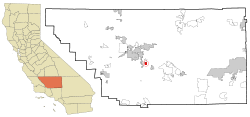 Location in California and in Kern County | |
 Weedpatch Location in the United States | |
| Coordinates: 35°14′17″N 118°54′54″W / 35.23806°N 118.91500°WCoordinates: 35°14′17″N 118°54′54″W / 35.23806°N 118.91500°W | |
| Government | |
| • Senate | Jean Fuller (R) |
| • Assembly | Rudy Salas (D) |
| • U. S. Congress | David Valadao (R) |
| Area[1] | |
| • Total | 3.561 sq mi (9.223 km2) |
| • Land | 3.557 sq mi (9.213 km2) |
| • Water | 0.004 sq mi (0.010 km2) 0.11% |
| Elevation[2] | 387 ft (118 m) |
| Population (2016) | |
| • Total | 25,000 |
| • Density | 7,000/sq mi (2,700/km2) |
| ZIP code | 93241 |
| Area code(s) | 661 |
| FIPS code | 06-83863 |
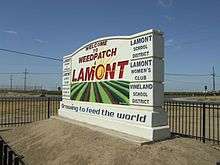
Weedpatch (formerly Weed Patch[2] and Alexander's Corner[3]) is an unincorporated community in Kern County, California. Weedpatch is 10 miles (16 km) south-southeast of Bakersfield. It is considered to be one of the poorest areas in Kern County.[4]
Geography
The community, which lies at an elevation of 387 feet (118 m), is situated off State Route 184 (Weedpatch Highway) southeast of Bakersfield, south of Lamont and about 5 miles (8.0 km) south of State Route 58, the Bakersfield - Tehachapi Highway. It is at 35°14′17″N 118°54′54″W / 35.23806°N 118.91500°W.[2] According to the United States Census Bureau, Weedpatch has an area of 3.6 square miles (9.3 km2).
History
Although the name Weed Patch was applied to the site as early as 1874, the community began only in 1922. The town was also named Alexander's Corner in honor of Cal Alexander, a resident.[3]
Weedpatch is the site of the Arvin Federal Government Camp, known colloquially (and in the John Steinbeck novel The Grapes of Wrath) as "Weedpatch Camp." This camp was a government rescue center for distressed migrant workers fleeing the Oklahoma Dust Bowl, during the Great Depression. The camp still aids migrant workers.
The camp is one mile (1.6 km) south of Weedpatch on Sunset just off Weedpatch Hwy.
Population
The 2010 United States Census reported that Weedpatch had a population of 2,658, with a median household income of $28,075 and just above 45.8% living at or below the poverty level. It is considered to have a young population, with a median age of 22.7.[4]
The racial makeup of Weedpatch was 1,212 (45.6%) white, 8 (0.3%) African American, 78 (2.9%) Native American, 14 (0.5%) Asian, 0 (0.0%) Pacific Islander, 1,237 (46.5%) from other races, and 109 (4.1%) from two or more races. Hispanic or Latino of any race were 2,484 persons (93.5%).
References
- ↑ U.S. Census
- 1 2 3 U.S. Geological Survey Geographic Names Information System: Weedpatch, California
- 1 2 Durham, David L. (1998). California's Geographic Names: A Gazetteer of Historic and Modern Names of the State. Clovis, Calif.: Word Dancer Press. p. 1125. ISBN 1-884995-14-4.
- 1 2 "Weedpatch Is Waiting to See the Light," Bakersfield Californian, February 21, 2010
