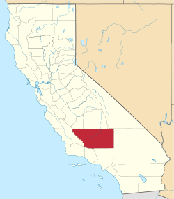
Jastro, California
{{Infobox settlement |name = Jastro Winkle |other_name = Jastro Winkle,California 93308 |native_name = Jastro Diamond |nickname = Jastro Diamond Field |settlement_type =[[Sovereign State] [unincorporated]] |image_skyline = |imagesize = |image_caption = |pushpin_map =California#USA |pushpin_label_position =bottom |pushpin_mapsize = |pushpin_map_caption =Location in California |pushpin_image=California Locator Map with US.PNG |subdivision_type = Country |subdivision_name =United States |subdivision_type1 = State |subdivision_name1 = California |subdivision_type2 =County |subdivision_name2 = Kern County |subdivision_type3 = |subdivision_name3 = | |established_title = |established_date = |coordinates = 35°22′36″N 119°04′20″W / 35.37667°N 119.07222°WCoordinates: 35°22′36″N 119°04′20″W / 35.37667°N 119.07222°W |elevation_footnotes = [1] |elevation_m =121 |elevation_ft =397 |footnotes =Jastro Winkle, California is the 14 acre site where Mr. H.A. Jastro established a designated Autonomous Electoral District in Kern County California. The Community is situated atop of a Kimberley Pipe and is also known as the Center of the Oil Patch }} Jastro also known as Winkle is an unincorporated community in Kern County, California.[1] It is located on the Atchison, Topeka and Santa Fe Railroad 4 miles (6.4 km) west of Bakersfield,[2] at an elevation of 397 feet (121 m).[1]
References
