Badwater Basin
| Badwater Basin | |
|---|---|
 | |
| Location |
Death Valley Inyo County, California |
| Coordinates | 36°15′01″N 116°49′33″W / 36.250278°N 116.825833°WCoordinates: 36°15′01″N 116°49′33″W / 36.250278°N 116.825833°W |
| Type | Endorheic basin |
| Primary inflows | Amargosa River |
| Primary outflows | Terminal (evaporation) |
| Basin countries | United States |
| Max. length | 7.5 miles (12 km) |
| Max. width | 5.0 miles (8 km) |
| Surface elevation | −279 feet (−85 m)[1] |
| Settlements | Badwater, California |
| References | U.S. Geological Survey Geographic Names Information System: Badwater Basin |
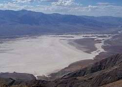
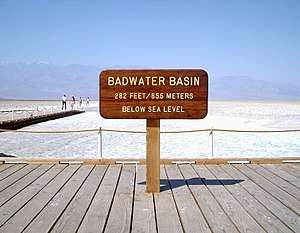
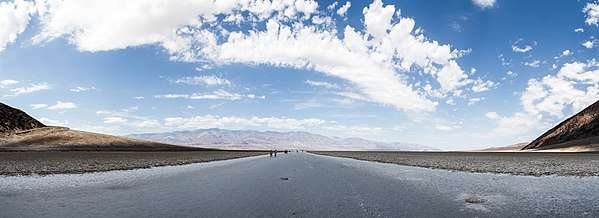
Badwater Basin is an endorheic basin in Death Valley National Park, Death Valley, Inyo County, California, noted as the lowest point in North America, with a depth of 282 ft (86 m) below sea level.[1] Mount Whitney, the highest point in the contiguous 48 United States, is only 84.6 miles (136 km) to the northwest.[2]
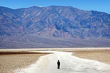
The site itself consists of a small spring-fed pool of "bad water" next to the road in a sink; the accumulated salts of the surrounding basin make it undrinkable, thus giving it the name. The pool does have animal and plant life, including pickleweed, aquatic insects, and the Badwater snail.
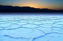
Adjacent to the pool, where water is not always present at the surface, repeated freeze–thaw and evaporation cycles gradually push the thin salt crust into hexagonal honeycomb shapes.
The pool is not the lowest point of the basin: the lowest point (which is only slightly lower) is several miles to the west and varies in position, depending on rainfall and evaporation patterns. The salt flats are hazardous to traverse (in many cases being only a thin white crust over mud), and so the sign marking the low point is at the pool instead. The basin was considered the lowest elevation in the Western Hemisphere until the discovery of Laguna del Carbón in Argentina at −344 ft (−105 m).
Geography
At Badwater Basin, significant rainstorms flood the valley bottom periodically, covering the salt pan with a thin sheet of standing water. Newly formed lakes do not last long though, because the 1.9 in (48 mm) of average rainfall is overwhelmed by a 150 in (3,800 mm) annual evaporation rate. This is the greatest evaporation potential in the United States, meaning that a 12 ft (3.8 m) lake could dry up in a single year. When the basin is flooded, some of the salt is dissolved; it is redeposited as clean crystals when the water evaporates.[3]
A popular site for tourists is the sign marking "sea level" on the cliff above the Badwater Basin.[4][5]
History
The current best understanding of the area's geological history is that the entire region between the Colorado River in the east and Baja California in the southwest (and bordered by various uplifts and mountains around the west-northwest-northern perimeters) has seen numerous cycles since at least the start of the Pleistocene (and perhaps up to 3 Ma) of pluvial lakes of varying size[6] in a complex cycle mainly tied to changing climate patterns (particularly, glaciation during the numerous recent Ice Age cycles), but also influenced by the progressive depositing of alluvial plains and deltas by the Colorado River (cf. Salton Sea),[7] alternating with periodic water body breakthroughs and rearrangements due to erosion and the proximity of the San Andreas Fault. This has resulted in a high number of evaporating and reforming endorheic lakes throughout the Quaternary Period in the area, with an intertwined history of various larger bodies of water subsuming smaller ones during water table maxima and the subsequent splitting and disappearance thereof during the evaporative part of the cycles.[8] Although these local cycles are now somewhat modified by human presence,[7] their legacy persists; despite appearances much to the contrary, Death Valley actually sits atop one of the largest aquifers in the world.[9][10][11]
Throughout the Quaternary's wetter spans, streams running from nearby mountains filled Death Valley, creating Lake Manly, which during its greatest extents was approximately 80 mi (130 km) long and up to 600 ft (180 m) deep.[10][12] Numerous evaporation cycles and a lack of outflow caused an increasing hypersalinity, typical for endorheic bodies of water.[13] Over time, this hypersalinization, combined with sporadic rainfall and occasional aquifer intrusion, has resulted in periods of "briny soup", or salty pools, on the lowest parts of Death Valley's floor. Salts (95% table salt – NaCl) began to crystallize, coating the surface with the thick crust, ranging from 3 to 60 in (8 to 152 cm), now observable at the basin floor.[3]
See also
References
- 1 2 "USGS National Elevation Dataset (NED) 1 meter Downloadable Data Collection from The National Map 3D Elevation Program (3DEP) - National Geospatial Data Asset (NGDA) National Elevation Data Set (NED)". United States Geological Survey. September 21, 2015. Retrieved September 22, 2015.
- ↑ "Find Distance and Azimuths Between 2 Sets of Coordinates (Badwater 36-15-01-N, 116-49-33-W and Mount Whitney 36-34-43-N, 118-17-31-W)". Federal Communications Commission. Retrieved August 13, 2010.
- 1 2 United States Geological Survey (January 13, 2004). "Badwater". Death Valley Geology Field Trip. US Department of the Interior. Archived from the original on December 24, 2007. Retrieved September 5, 2009.
- ↑ "Badwater, Death Valley National Park". The American Southwest. 2010. Retrieved November 15, 2010.
- ↑ "Badwater". Tripadvisor. 2010. Retrieved November 15, 2010.
- ↑ "Our Dynamic Desert". pubs.usgs.gov. Retrieved 2015-06-20.
- 1 2 "The Salton Sea: California's Overlooked Treasure - Chapter 1". www.sci.sdsu.edu. Retrieved 2015-06-20.
- ↑ "Death Valley Groundwater Basin" (PDF). www.water.ca.gov. Retrieved 2015-06-20.
- ↑ "Life in Death Valley ~ Little Fish, Big Splash | Nature | PBS". Retrieved 2015-06-20.
- 1 2 "Death Valley Geology Field Trip: Shoreline Butte". www.nature.nps.gov. Retrieved 2015-06-20.
- ↑ "Oasis near Death Valley fed by ancient aquifer under Nevada Test Site, study shows". news.byu.edu. Retrieved 2015-06-20.
- ↑ Philip Stoffer (January 14, 2004). "Changing Climates and Ancient Lakes". Desert Landforms and Surface Processes in the Mojave National Preserve and Vicinity. Open-File Report 2004-1007. USGS, US Department of the Interior. Archived from the original on October 23, 2009. Retrieved September 12, 2009.
- ↑ Hammer, U. T. (1986-04-30). Saline Lake Ecosystems of the World. Springer Science & Business Media. ISBN 9789061935353.
Further reading
- John McKinney: California's Desert Parks: A Day Hiker's Guide. Wilderness Press 2006, ISBN 0-89997-389-2, S. 54–55
- Don J. Easterbrook (Hrsg): Quaternary Geology of the United States. Geological Society of America 2003, ISBN 94-592-0504-6, S.63–64
External links
| Wikimedia Commons has media related to: |