Rapid Bay, South Australia
| Rapid Bay South Australia | |||||||||||||||
|---|---|---|---|---|---|---|---|---|---|---|---|---|---|---|---|
 Rapid Bay shoreline | |||||||||||||||
 Rapid Bay | |||||||||||||||
| Coordinates | 35°31′39″S 138°11′22″E / 35.527537°S 138.18951°ECoordinates: 35°31′39″S 138°11′22″E / 35.527537°S 138.18951°E[1] | ||||||||||||||
| Population | 16 (2016 census)[2] | ||||||||||||||
| Postcode(s) | 5204 | ||||||||||||||
| Time zone | ACST (UTC+9:30) | ||||||||||||||
| • Summer (DST) | ACDT (UTC+10:30) | ||||||||||||||
| Location | 100 km (62 mi) S of Adelaide | ||||||||||||||
| LGA(s) | District Council of Yankalilla | ||||||||||||||
| Region | Fleurieu and Kangaroo Island[3] | ||||||||||||||
| County | Hindmarsh[1] | ||||||||||||||
| State electorate(s) | Mawson [4] | ||||||||||||||
| Federal Division(s) | Mayo | ||||||||||||||
| |||||||||||||||
| |||||||||||||||
| Footnotes | Adjoining localities[1] | ||||||||||||||
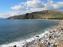
Rapid Bay is the name of both a locality (postcode 5204) including a small seaside town and a small bay on the west coast of the Fleurieu Peninsula, South Australia. It lies within the District Council of Yankalilla and its township is approximately 100 km south of the state capital, Adelaide. It is well known for its limestone quarry and its pair of jetties which are popular sites for recreational fishing, scuba diving and snorkelling.
History
Rapid Bay features in the creation myths of both the Kaurna and Ramindjeri people, most notably as the burial site of creation ancestor Tjilbruke's nephew.[6]
South Australia Colonial Surveyor General Colonel William Light made his first landfall on mainland South Australia at Rapid Bay on 8 September 1836.[7] The site was named after Light's ship, the 162 ton brig Rapid. To mark this historic landfall the Colonel's initials, "W.L.", were carved into a large boulder – a replica is visible in the township, while the original is stored in the South Australian Museum, in Adelaide. John Rapid Hoare (7 November 1836 – perhaps 7 July 1916),[8] also named for the brig Rapid, was the first European child born on mainland South Australia. Claims that he was born at Rapid Bay[9] have been refuted.[10]
For a short time Rapid Bay was considered a potential site for the new state capital, but with the discovery of the Adelaide Plains it faded into quiet obscurity.
The Broken Hill Proprietary (BHP) constructed the town, an ore-loading jetty and a high voltage power line from Willunga during the period 1938 to 1942 as part of the works undertaken to establish the limestone quarry. Mining commenced in 1942.[11] The limestone was used as a flux in the company's steelworks at Whyalla in South Australia, and Newcastle and Port Kembla in New South Wales.[12]
On 1 January 1982, ownership of the jetty was transferred to the Government of South Australia from BHP at no cost. The quarry was purchased by Adelaide Brighton Cement.[13]
Attractions
Rapid Bay is known for its imposing cliffs, caves, beach, two jetties and artificial reefs. A resident leafy seadragon population inhabits the bay and weedy seadragons are also sometimes seen. It is considered to be one of Australia's premiere scuba diving sites,[14] and has been listed featured on SportDiver as one of the world's top 9 dives.[15] The ecological communities on the jetty pylons are well established and attract large schools of fish including Old Wives and Zebra Fish. At least 49 species of fish have been recorded in the vicinity of the Rapid Bay jetties.[16] Giant Australian Cuttlefish and Blue-ringed octopus can also be found on the sea floor.
It is also a popular recreational fishing site, though the longer historic jetty is closed to fishermen due to its state of natural decay.
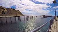
Jetties
BHP Jetty
The BHP Jetty was originally 490 metres (1,600 ft) long, with a 'T' section of 200 metres (650 ft) length for ship-loading. The jetty terminated in 9.1 metres (30 ft) of water (at lowest tide).[17] Originally built by BHP and later operated by Adelaide Brighton Cement, the jetty ceased commercial operations in 1991.[13] It suffered storm damage in 2004, after which it was progressively closed in stages for the purpose of ensuring public safety. Above the water, the jetty is slowly decaying and is off-limits to the general public. Below the water, the jetty provides habitat for a wide variety of temperate marine species. Since its closure, the above-water structure has also become an increasingly valuable roost for seabirds.
Public Jetty
Construction of a new jetty of 240 metres (790 feet) length located 50 metres (160 feet) east of the BHP jetty was completed in 2009 to replace the public amenity lost by the progressive closure of the BHP jetty.[18][19]
The new jetty has since been colonised by marine life and augments the more established ecological communities on and around the historic jetty. At the seaward end, a staircase provides safe and easy entry to the water for divers and snorkellers. The jetty features concrete decking, is artificially lit after nightfall and is a popular spot for recreational fishing.
Gallery
 Rapid Bay old jetty
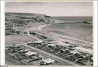 View of the Town, the Quarry and the Jetty looking west towards Rapid Head (image created in 1950)
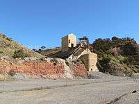 The limestone quarry at Rapid Bay as seen from the public car park for the jetty.
See also
References
- 1 2 3 "Search results for 'Rapid Bay, LOCB' with the following datasets being selected - 'Suburbs and Localities', 'Postcode', 'Government Towns', 'Counties', 'Hundreds', 'Local Government Areas', 'SA Government Regions', 'Land Development Plan Zone Categories' and 'Gazetteer'". Location SA Map Viewer. Government of South Australia. Retrieved 4 March 2018.
- ↑ Australian Bureau of Statistics (27 June 2017). "State Suburb of Rapid Bay". 2016 Census QuickStats. Retrieved 4 March 2018.

- ↑ "Fleurieu Kangaroo Island SA Government region" (PDF). The Government of South Australia. Retrieved 17 April 2017.
- ↑ Mawson (Map). Electoral District Boundaries Commission. 2016. Retrieved 2 March 2018.
- 1 2 3 "Climate statistics for PARAWA (SECOND VALLEY FOREST AWS) (nearest station)". Bureau of Meteorology. Retrieved 4 March 2018.
- ↑ City of Holdfast Bay: Tjilbruke Heritage & the Kaurna People Archived 12 July 2010 at the Wayback Machine.
- ↑ Elder, David F., 'Light, William (1786–1839)', Australian Dictionary of Biography, National Centre of Biography, Australian National University, , accessed 11 October 2012.
- ↑ "Family Notices". The Sydney Morning Herald (24, 503). New South Wales, Australia. 19 July 1916. p. 10. Retrieved 29 June 2017 – via National Library of Australia.
- ↑ "The Firstborn South Australian Male". The Advertiser (Adelaide). XLIII, (13, 310). South Australia. 15 June 1901. p. 11. Retrieved 29 June 2017 – via National Library of Australia.
- ↑ "South Australia's Oldest Natives". The Daily Herald (Adelaide). X, (3012). South Australia. 14 November 1919. p. 4. Retrieved 29 June 2017 – via National Library of Australia.
- ↑ Cowan, David. "History". Friends of Rapid Bay Jetty. Retrieved 11 October 2012.
- ↑ "Limestone". Geological Survey of SA. Retrieved 27 August 2014.
- 1 2 Friends of Rapid Bay Jetty > History. Accessed 2014-03-21
- ↑ Australia 'the best destination for shore diving'
- ↑ "9 world's best dives" SportDiver.com. Accessed 2014-03-20.
- ↑ Atlas of Living Australia > Rapid Bay Jetty > Fishes. Accessed 2014-03-22
- ↑ The Recorder "B.H.P. at Rapid Bay - Limestone Plant Near Completion" (1942-04-17) Retrieved 2013-11-20.
- ↑ 'Rapid Bay', , retrieved 11/10/2012.
- ↑ "Archived copy". Archived from the original on 6 July 2011. Retrieved 27 June 2010.
External links
- Friends of Rapid Bay Jetty, retrieved 11/10/2012.
| Wikimedia Commons has media related to Rapid Bay, South Australia. |