Deep Creek Conservation Park
| Deep Creek Conservation Park South Australia | |
|---|---|
|
IUCN category II (national park) | |
 Deep Creek Conservation Park | |
| Nearest town or city | Cape Jervis |
| Coordinates | 35°37′40″S 138°13′19″E / 35.62778°S 138.22194°ECoordinates: 35°37′40″S 138°13′19″E / 35.62778°S 138.22194°E |
| Established | 1 January 1971[1] |
| Area | 44.96 km2 (17.4 sq mi)[2] |
| Managing authorities | Department of Environment and Water |
| Website | Deep Creek Conservation Park |
| See also | Protected areas of South Australia |
Deep Creek Conservation Park is a protected area in the Australian state of South Australia located on the southern coast of Fleurieu Peninsula in the gazetted localities of Deep Creek and Delamere about 11 kilometres (6.8 miles) east of Cape Jervis.[3] The Park encompasses 18 kilometres (11 miles) of coastline, which include views across Backstairs Passage to Kangaroo Island. The Park consists of mainly rolling coastal hills, the gullies of which contain orchids and ferns, while the hilltops have stunted scrub and low windswept trees. Walking trails (including part of the famous Heysen Trail) provide access to most of the Park. The Park is classified as an IUCN class II protected area.[2]
Notable walks
There are many walks in the Park, ranging from easy walks, through to moderate and hard hikes. Overnight treks are also possible by linking walks.[4]
- Easy Walks
- Stringybark Loop Walk: An easy 20-minute nature trail through stringybark and yacca-bush forest. Information boards are located at intervals along the way.
- Forest Circuit Walk: An easy walk through the forest near Stringybark Campground.
- Spring Wildflower Walk: A walk that follows fire trails from Stringybark Campground.
- Moderate Hikes
- Deep Creek Waterfall from Tent Rock Road: Descends steeply to the Deep Creek Waterfall. The walk is not long and the track is well maintained with steps in steeper sections. The return walk is mostly uphill.
- Deep Creek Cove from Trig Camping Area: Descends moderately to Deep Creek Cove. The return walk is a long moderate ascent.
- Aaron Creek Circuit Hike: A circuit hike that crosses the open areas at the higher sections of the park before descending toward Eagle Waterhole Campground. Plenty of Western grey kangaroos can be seen on this hike.
- Hard Hikes
- Deep Creek Cove from Tapanappa Lookout: A spectacular and challenging hike that involves some steep hills and scrambling in some places. Hiking boots are required as there are steep and slippery sections in close proximity to cliff edges.
- Blowhole Beach Hike: Descends to Blowhole Beach from Cobbler Hill. Can be incredibly windy. The track is not especially rough but the ascent on the return hike is long and steep.
- Deep Creek Waterfall from Tapanappa Lookout: Another spectacular and challenging hike that has some long and steep undulations. This walk goes right into the dense Deep Creek vegetation and is not a leisurely stroll.
- Aaron Creek Hike: Follows the creek to the coast, many creek crossings involved, and stunning views.
- The Heysen Trail
The Heysen Trail enters the Park near Blowhole Beach, not far from its starting point at Cape Jervis. It traverses the Park via Eagle Waterhole, Trig Campground, and Deep Creek Waterfall, and exits at Boat Harbour beach before continuing to Tunkalilla Beach. It is well marked with the red and white Heysen Trail track markers.
Camping
The Park has five camping areas available with various facilities.
- Stringybark: A sheltered forest setting with 16 sites, hot showers, toilets and rain water. Sites available for caravans and camp trailers. No powered sites available.
- Trig: Central to the main hiking trails, open grassy areas with many well-sheltered and shady sites. 25 sites, toilets and rain water available. Sites available for caravans and camp trailers. No powered sites available.
- Tapanappa: 18 moderately sheltered sites with spectacular coastal views close by. Toilets and rain water available.
- Cobbler Hill: 10 sites with toilets and rain water close to Blowhole Beach. Can be exposed during windy conditions.
- Eagle Waterhole: Located on the Heysen Trail, and only able to be used by hikers. A hikers' hut and rainwater tank have been erected at this site.
Gallery
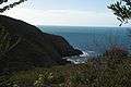 Approaching the cove at the mouth of Deep Creek.
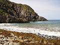 Looking south.
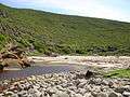 The creek mouth.
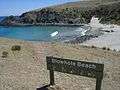 Blowhole Beach.
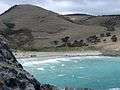 Blowhole Beach looking North East.
See also
References
- ↑ "Protected Areas Information System - reserve list (as of 17 Feb 2014)" (PDF). Department of Environment Water and Natural Resources. p. 5. Retrieved 16 March 2014.
- 1 2 "CAPAD 2012 South Australia Summary (see 'DETAIL' tab)". CAPAD 2012. Australian Government - Department of the Environment. 6 February 2014. Retrieved 6 February 2014.
- ↑ "Search result for "Deep Creek Conservation Park" (Record no SA0019531) with the following layers selected - "Suburbs and Localities" and " Place names (gazetteer)"". Property Location Browser. Government of South Australia. Retrieved 8 August 2016.
- ↑ "Bushwalking in Deep Creek Conservation Park". Department for Environment and Heritage. June 2004. Archived from the original (PDF) on 31 August 2006. Retrieved 2006-08-25.