Second Valley, South Australia
| Second Valley South Australia | |||||||||||||||
|---|---|---|---|---|---|---|---|---|---|---|---|---|---|---|---|
 The jetty | |||||||||||||||
 Second Valley | |||||||||||||||
| Coordinates | 35°31′26″S 138°13′19″E / 35.523807°S 138.22184°ECoordinates: 35°31′26″S 138°13′19″E / 35.523807°S 138.22184°E[1] | ||||||||||||||
| Population | 162 (2016 census)[2] | ||||||||||||||
| Postcode(s) | 5204[3] | ||||||||||||||
| Time zone | ACST (UTC+9:30) | ||||||||||||||
| • Summer (DST) | ACDT (UTC+10:30) | ||||||||||||||
| Location |
| ||||||||||||||
| LGA(s) | District Council of Yankalilla[1] | ||||||||||||||
| Region | Fleurieu and Kangaroo Island[4] | ||||||||||||||
| County | Hindmarsh[1] | ||||||||||||||
| State electorate(s) | Mawson [5] | ||||||||||||||
| Federal Division(s) | Mayo[6] | ||||||||||||||
| |||||||||||||||
| |||||||||||||||
| Footnotes |
Locations[3][1] Adjoining localities[1] | ||||||||||||||
Second Valley is a coastal town on the Fleurieu Peninsula in South Australia.
The name is derived from being the next valley north of Rapid Bay, the initial camp on South Australian mainland of Colonel William Light. It is a popular scuba diving destination.
Despite its small size, Second Valley has been rated as one of Australia's top ten beaches, with the variety of activities and opportunities to explore cited as contributing factors.[8]
Governance
Second Valley is located within the federal division of Mayo, the state electoral district of Mawson and the local government area of the District Council of Yankalilla.[5][6][1]
Gallery
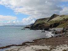 The rugged coastline north of Second Valley.
 The rugged coastline south of Second Valley jetty looking towards Rapid Bay.
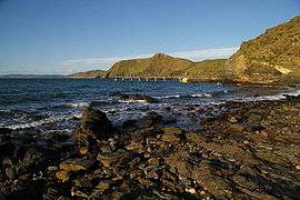
See also
References
- 1 2 3 4 5 6 "Search results for 'Second Valley, LOCB' with the following datasets being selected - 'Suburbs and Localities', 'Government Towns', 'Counties', 'Local Government Areas', 'SA Government Regions', 'Gazetteer' and 'Roads'". Location SA Map Viewer. Government of South Australia. Retrieved 20 May 2018.
- ↑ Australian Bureau of Statistics (27 June 2017). "Second Valley". 2016 Census QuickStats. Retrieved 20 May 2018.

- 1 2 "Postcode for Second Valley, South Australia". postcodes-australia.com. Retrieved 20 May 2018.
- ↑ "Fleurieu Kangaroo Island SA Government region" (PDF). The Government of South Australia. Retrieved 17 April 2017.
- 1 2 Mawson (Map). Electoral District Boundaries Commission. 2016. Retrieved 2 March 2018.
- 1 2 "Federal electoral division of Mayo, boundary gazetted 16 December 2011" (PDF). Australian Electoral Commission. Retrieved 2 August 2015.
- 1 2 3 "Summary (climate) statistics PARAWA (SECOND VALLEY FOREST AWS)". Commonwealth of Australia , Bureau of Meteorology. Retrieved 8 January 2016.
- ↑ Allan, Roxanne (9 November 2012). "Line in sand drawn over South Australia's best beach". Advertiser.com.au. Retrieved 2 June 2014.
External links
- "Second Valley - Divemaster course mapping project" (PDF). Adelaide Scuba (PDF). October 2011.
This article is issued from
Wikipedia.
The text is licensed under Creative Commons - Attribution - Sharealike.
Additional terms may apply for the media files.