Wirrina Cove
| Wirrina Cove South Australia | |||||||||||||||
|---|---|---|---|---|---|---|---|---|---|---|---|---|---|---|---|
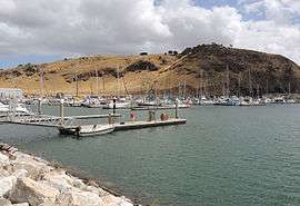 Marina St. Vincent, Wirrina Cove | |||||||||||||||
 Wirrina Cove | |||||||||||||||
| Coordinates | 35°29′44″S 138°16′06″E / 35.495613°S 138.268250°ECoordinates: 35°29′44″S 138°16′06″E / 35.495613°S 138.268250°E | ||||||||||||||
| Population | 497 (shared with other localities in the “State Suburb of Wirrina Cove”) (2011 census)[1][lower-alpha 1] | ||||||||||||||
| Established | 1999[2] | ||||||||||||||
| Postcode(s) | 5204[3] | ||||||||||||||
| Time zone | ACST (UTC+9:30) | ||||||||||||||
| • Summer (DST) | ACST (UTC+10:30) | ||||||||||||||
| Location | 70 km (43 mi) south west of Adelaide city centre | ||||||||||||||
| LGA(s) | District Council of Yankalilla | ||||||||||||||
| Region | Fleurieu and Kangaroo Island[4] | ||||||||||||||
| State electorate(s) | Mawson [5] | ||||||||||||||
| Federal Division(s) | Mayo[6] | ||||||||||||||
| |||||||||||||||
| |||||||||||||||
| Footnotes |
Location[2][3] Climatic data[7] | ||||||||||||||
Wirrina Cove is a locality on the Fleurieu Peninsula, South Australia. It is located between the coastal towns of Second Valley and Normanville on Yankalilla Bay. Features include a 270 berth marina named Marina St. Vincent, holiday accommodation and a golf course.[8] The marina was initially approved for development in 1988. It was intended to support regional tourism opportunities, including sunset cruises and day trips across Backstairs Passage to Kangaroo Island.[9]
Marina
The Wirrina Cove marina received planning approval from the Government of South Australia in 1988. Construction was expected to start in 1989 and take 10 months to complete.[10] At the time of its construction, it was described as a $45 million project.[11] After its completion, the marina was renamed Marina St. Vincent.
References
- Notes
- ↑ The State Suburb of Wirrina Cove includes the following gazetted localities: Deep Creek, Delamere, Rapid Bay, Second Valley, Silverton and Wirrina Cove
- Citations
- ↑ Australian Bureau of Statistics (31 October 2012). "Wirrina Cove". 2011 Census QuickStats. Retrieved 25 April 2016.

- 1 2 3 4 5 6 7 8 9 10 "Placename Details: Wirrina Cove (locality bounded) with the following layers selected - "Suburbs and Localities" and " Place names (gazetteer)"". Property Location Browser. Government of South Australia. 26 February 2007. SA0040318 (suburb). Retrieved 8 January 2016.
- 1 2 "Wirrina Cove Postcode". Australian Postcode Search. Retrieved 8 January 2016.
- ↑ "Fleurieu Kangaroo Island SA Government region" (PDF). The Government of South Australia. Retrieved 17 April 2017.
- ↑ Mawson (Map). Electoral District Boundaries Commission. 2016. Retrieved 2 March 2018.
- ↑ "Federal electoral division of Mayo, boundary gazetted 16 December 2011" (PDF). Australian Electoral Commission. Retrieved 2 August 2015.
- ↑ "Summary (climate) statistics PARAWA (SECOND VALLEY FOREST AWS)". Commonwealth of Australia , Bureau of Meteorology. Retrieved 8 January 2016.
- ↑ "Map of Wirrina Cove, SA 5204 | Whereis®". www.whereis.com. Retrieved 2015-12-10.
- ↑ "John promotes Fleurieu as total tourism package". Times. 1988-07-06. p. 11. Retrieved 2015-12-13.
- ↑ "Work to start on new marina soon". Times. 1989-06-21. p. 2. Retrieved 2015-12-13.
- ↑ "Wirrina marina launched". Times. 1989-12-06. p. 1. Retrieved 2015-12-13.