Ramailo, Nepal
| Ramailo रमाइलो | |
|---|---|
| village | |
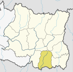
 Ramailo Location of Ramailo in Nepal | |
| Coordinates: 26°36′59.94″N 87°29′56.30″E / 26.6166500°N 87.4989722°ECoordinates: 26°36′59.94″N 87°29′56.30″E / 26.6166500°N 87.4989722°E | |
| Country |
|
| Zone | Kosi Zone |
| District | Morang District |
| Elevation | 122.2248 m (401.0000 ft) |
| Population (1991) | |
| • Total | 12,150 |
| est. | |
| Time zone | UTC+5:45 (Nepal Time) |

Sunrise in Ramailo
Ramailo (Nepali: रमाइलो) is a Bayarban, Kanepokhari Rural Municipality (Nepal) in Morang District in the Kosi Zone of south-eastern Nepal. At the time of the 1991 Nepal census it had a population of 12,150.[1]
Village Development Committee
- Village Development Committee is located at Ramailo, near by Janasewa Higher Secondary School Ramailo.
- Ramailo Nepal is listed as Ward number 8, and it has high density among the other wards. Locality of Ramailo is better than compared to Balaju of Kathmandu. Ramailo is now the premier cultural and economic hub of BayarbanKeroun VDC Nepal and is considered to have the most advanced infrastructure among urban areas in VDC. From the point of view of tourism, economy and cultural heritage, the sister cities of Belbari and Pathari are integral to Ramailo. The World Heritage list of UNESCO has recognized all the monuments in the three urban agglomerates as one unit under the title Ramailo.
Ramailo, as the gateway to VDC Tourism, is the nerve centre of the VDC’s economy. With the most advanced infrastructure among urban areas in VDC, Ramailo's economy is agriculture,trade centric accounting.
List of School in Ramailo VDC
- Ramailo Baljagat English School
- Shree Janasewa Higher Secondary School
- Pearl Academy English School
- Mount Hermon English School
- Zenith English schoo
- Ramailo Academy English School
References
- ↑ "Nepal Census 2001". Nepal's Village Development Committees. Digital Himalaya. Retrieved 15 December 2008.
- ↑ List of school in Nepal
This article is issued from
Wikipedia.
The text is licensed under Creative Commons - Attribution - Sharealike.
Additional terms may apply for the media files.