Raipur, Nepal
| Raipur, Nepal रायपुर | |
|---|---|
| Municipality | |
 Raipur, Nepal Location in Nepal | |
| Coordinates: 28°04′N 83°58′E / 28.06°N 83.97°ECoordinates: 28°04′N 83°58′E / 28.06°N 83.97°E | |
| Country |
|
| Province | Province No. 4 |
| District | Tanahu District |
| Population (1991) | |
| • Total | 4,581 |
| Time zone | UTC+5:45 (Nepal Time) |
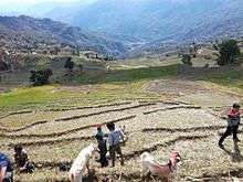
Raipur is part of Shuklagandaki (Nepali: शुक्लगण्डकी) municipality in Tanahu District in the Province No. 4, Gandaki of central Nepal. It is included in Ward No 11 of Shuklagandaki municipality in March 2017. At the time of the 1991 Nepal census it had a population of 4581 people living in 850 individual households. It is about 18 km west from Dulegaunda Town & about 20 km from Putalibazar of Syangja District. This village has views of Annapurna and Dhaulagiri Range. The lifestyle of people living in Raipur is simple, and the majority are farmers. Most of the people from Raipur are migrated to Pokhara, Kaski and Bharatpur, Chitwan. About 90% of youths of Raipur are at Third Countries and Gulf for employment. All the areas of Raipur has good drinking water facilities, electricity, and good road access. Tuka Raj Sigdel of CPN UML is the leader of this region and has been elected more than once.
Hospitals
Located 15 km away from Dulegaunda in Sankhe, the 15 bed Phoolbari Community Hospital has an MBBS doctor, a nurse, health assistants, laboratory technicians including caretakers to attend to the needs of the patients visiting the hospital for treatment. The hospital has been providing 24-hour emergency service, out-patient department, infant and maternity services along with treatment facilities such as x-ray and ultrasound. With the establishment of the hospital, locals have been able to access medical service within the village itself.
Transportation
This village has access to Prithivi Highway and Siddhartha Highway within a single hour. From Raipur, ThumkiDada, Bisauna, Bajhakhet, Odare are the hubs where local buses and jeeps are available for Dulegaunda and Syangja Bazar.[1]
References
- ↑ "Nepal Census 2001", Nepal's Village Development Committees, Digital Himalaya, retrieved 15 November 2009 .
External links
- UN map of the municipalities of Tanahu District
- Phoolbari Community Hospital
- Facebook Group :: Hamro Raipur
Headquarters: Damauli (today part of Byas Municipality) | ||
| Municipalities | 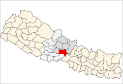 | |
| Rural municipalities |
| |
| Former VDCs |
| |