Anbu Khaireni
| Aanbookhaireni आँबुखैरेनि गाउँपालिका | |
|---|---|
| Rural Municipality | |
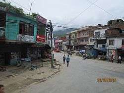 The starting point of Anbukhaireni Gorkha Road | |
 Aanbookhaireni Location in Nepal | |
| Coordinates: 27°54′13″N 84°32′24″E / 27.9037°N 84.5399°ECoordinates: 27°54′13″N 84°32′24″E / 27.9037°N 84.5399°E | |
| Country |
|
| Zone | Gandaki Zone |
| District | Tanahu District |
| Area | |
| • Total | 67.3 km2 (26.0 sq mi) |
| Population (2011) | |
| • Total | 16,382 |
| • Density | 240/km2 (630/sq mi) |
| Time zone | UTC+5:45 (NST) |
Anbu Khaireni, also Aanbu Khaireni, Aanboo Khaireni or Anbukhaireni, is a Municipality in Tanahu District in the Gandaki Zone of central Nepal established in 2015. At the time of the 1991 Nepal census it had a population of 11.450 people living in 2234 individual households. In the census of 2011 the municipality has 16.382 inhabitants.[1][2]
The Andhi Khola River flows nearby. On its right bank is Satrasaya Phant, which was once a dense forest.[3] The Anpu copper mines lie within a kilometre from the village.[4]
To Promote local culture Anbu khaireni has one FM radio stations Mero Sathi F.M - 107.2 MHz Which is a Community radio Station.
References
- ↑ "Nepal Census 2001", Nepal's Village Development Committees, Digital Himalaya, archived from the original on 12 October 2008, retrieved 15 November 2009 .
- ↑ http://www.muannepal.org.np/profiles.html
- ↑ Pradham, Rajendra (1997). Water Rights, Conflict and Policy: Proceedings of a Workshop Held in Kathmandu, Nepal January 22-24, 1996. IWMI. p. 139. ISBN 978-92-9090-185-3.
- ↑ Atlas of mineral resources of the ESCAP region: Geology and mineral resources of Nepal. United Nations. 1993.
External links
Headquarters: Damauli (today part of Byas Municipality) | ||
| Municipalities | 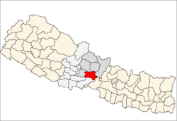 | |
| Rural municipalities |
| |
| Former VDCs |
| |
This article is issued from
Wikipedia.
The text is licensed under Creative Commons - Attribution - Sharealike.
Additional terms may apply for the media files.