Pieria (regional unit)
| Pieria Περιφερειακή ενότητα Πιερίας | |
|---|---|
| rl unit | |
 Municipalities of Pieria | |
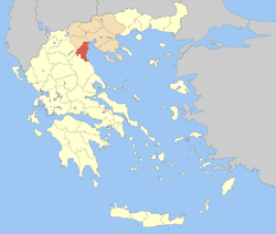 Pieria within Greece | |
| Coordinates: 40°15′N 22°25′E / 40.250°N 22.417°ECoordinates: 40°15′N 22°25′E / 40.250°N 22.417°E | |
| Country | Greece |
| Region | Central Macedonia |
| Capital | Katerini |
| Government | |
| • Vice Governor | Sofia Mavridou |
| Area | |
| • Total | 1,516 km2 (585 sq mi) |
| Population (2011) | |
| • Total | 126,698 |
| • Density | 84/km2 (220/sq mi) |
| Time zone | UTC+2 |
| • Summer (DST) | UTC+3 (EEST) |
| Postal codes | 60x xx |
| Area codes | 235x0 |
| Car plates | ΚΝ |
| Website |
www |
Pieria (Greek: Πιερία) is one of the regional units of Greece located in the southern part of the Region of Central Macedonia, within the historical province of Macedonia. Its capital is the town of Katerini. Pieria is the smallest regional unit within Macedonia. The name Pieria originates from the ancient Pieres tribe. In Pieria, there are many sites of archeological interest, such as Dion, Pydna, Leivithra and Platamonas. Pieria is also home to Mt. Pierus from which Hermes takes flight in order to visit Calypso (Odyssey 5.50), home to Orpheus[1] and the Muses,[2] as well as the Pierian Spring. Mt. Olympus, the highest mountain in Greece and throne of the ancient Greek gods, is located in the southern part of Pieria. Other ancient cities included Leibethra and Pimpleia.
Geography
The Pieria regional unit is bordered by Larissa (Thessaly) to the south and west, Kozani to the west and Imathia to the north. The Pierian Mountains lie to the west. The Thermaic Gulf lies to the east. It also has a valley by the GR-13. Most of the population live within the Olympian Riviera. The lowest point is the Thermian Gulf and the highest point is Mount Olympus.
It combines extensive plains, high mountains and sandy beaches. The region's beauty gives it a great potential for further tourist development.
Climate
Its climate is mainly of Mediterranean type with hot summers and cool winters. Severe winter weather is common in the central and western parts of Pieria, especially in the Pierian Mountains and on Mount Olympus.
On June 8, 2007, a low pressure weather system from Southern and Central Europe resulted in heavy rainfall that ravaged the prefecture and caused great damage in fruit and vegetable production. The worst hit area was Korinos.
Administration
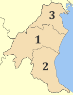
The regional unit Pieria is divided into 3 municipalities. These are (number as in the map in the infobox):[3]
- Dio-Olympos (2)
- Katerini (1)
- Pydna-Kolindros (3)
Prefecture
As a part of the 2011 Kallikratis government reform, the regional unit Pieria was created out of the former prefecture Pieria (Greek: Νομός Πιερίας). The prefecture had the same territory as the present regional unit. At the same time, the municipalities were reorganised, according to the table below.[3]
History
The region, known as Pieria or Pieris (Ancient Greek: Πιερία/Πιερίς) in Antiquity, took its name from the Pieres (Πίερες), a Thracian[4] tribe that was expelled[5] by the Macedonians in the 8th century BC[6] from their original seats, and driven to the North beyond the Strymon river and Mount Pangaeus,[5] where they formed a new settlement in Edonis. The name Pieria has been connected to Homeric πῖαρ "fat", πίειραν ἄρουραν "fertile land" in a metaphorical sense.[7]
At some time before the archaic period Pieria was incorporated in the Kingdom of Macedon (808 BC, see below) when it became the second province of the ancient kingdom, following its fate through the rule of the Antipatrid dynasty (302 BC - 277 BC) and the Antigonid dynasty (306 BC - 168 BC). It became part of the Roman Republic after the Fourth Macedonian War, and remained part of the Roman Empire and its successor, the Byzantine Empire.
It was later invaded and became a part of the Ottoman Empire. During the Greek War of Independence in 1821, Pieria took up arms along with the rest of Greece, but their struggle failed and Pieria did not join the rest of Greece until the Balkan Wars in 1913. Until 1947, Pieria was part of the Thessaloniki Prefecture (at that time the largest Greek prefecture), as a province. Pieria saw an economic boom in agriculture and business. During the Greco-Turkish War, it saw an influx of refugees from Asia Minor, now a part of Turkey, and several places were named after their former homelands including Nea Trapezounta from Trebizond (now Trabzon) and Nea Efesos from Ephesus (now Efes). The village of Elafos in the municipal unit Elafina, formerly a community in the Imathia prefecture, was united with Pieria in 1974.[8]
Transport
Notable People
Sporting teams
- Pierikos - Greek Second Division (North Club)
- Pierian Sodality
See also
References
- ↑ Orpheus and Greek Religion (Mythos Books) by William Keith Guthrie and L. Alderlink, 1993, ISBN 0-691-02499-5, page 62
- ↑ E.C. Marchant, Commentary on Thucydides: Book 2,Πιερίας—between Mt. Olympus and the Thermaic Gulf, the original home of the Muses and birth-place of Orpheus.
- 1 2 "Kallikratis reform law text" (PDF).
- ↑ Orpheus and Greek Religion (Mythos Books) by William Keith Guthrie and L. Alderlink,1993,page 62: "... assigned, Pieria, was originally inhabited by a Thracian tribe, the Pieres, who according to Thucydides (ii. ..."
- 1 2 Archaic Eretria: A Political and Social History from the Earliest Times to 490 BC by Keith G. Walker,2004,page 154: "... 498-54)12' had incorporated coastal Pieria into Macedonia and expelled the 'Pieres', who afterwards took up their abode in areas at Mt.Pangaion..."
- ↑ An Inventory of Archaic and Classical Poleis: An Investigation Conducted by The Copenhagen Polis Centre for the Danish National Research Foundation, ISBN 0-19-814099-1,2005,page 865
- ↑ J.P. Mallory, D. Q. Adams, The Oxford Introduction to Proto-Indo-European and the Proto-Indo-European world, Oxford University Press, 2006, pg. 261
- ↑ Administrative changes in local government
- ↑ https://www.csmonitor.com/1981/1014/101453.html
External links
| Wikimedia Commons has media related to Pieria. |
- https://web.archive.org/web/20040619183945/http://www.culture.gr/maps/macedon/pieria/pieria.html
- Pieria (regional unit) at Curlie (based on DMOZ) (in English)
- http://www.mpa.gr/specials/olympus/pieria.html
- https://web.archive.org/web/20050526214627/http://users.pie.sch.gr/amgr1/pieria_photos.htm
Administrative division of the Central Macedonia Region | ||
|---|---|---|
| ||
| Regional unit of Chalkidiki |  | |
| Regional unit of Imathia | ||
| Regional unit of Kilkis | ||
| Regional unit of Pella | ||
| Regional unit of Pieria | ||
| Regional unit of Serres | ||
| Regional unit of Thessaloniki | ||
| ||