Nea Zichni
| Nea Zichni Νέα Ζίχνη | |
|---|---|
 | |
 Nea Zichni Location within the region 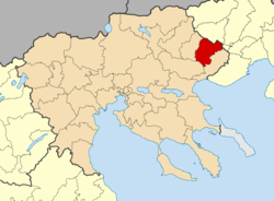 | |
| Coordinates: 41°02′N 23°50′E / 41.033°N 23.833°ECoordinates: 41°02′N 23°50′E / 41.033°N 23.833°E | |
| Country | Greece |
| Administrative region | Central Macedonia |
| Regional unit | Serres |
| Government | |
| • Mayor | Dairetzis Andreas (since 7 November 2010, first election 22 October 2006) |
| Area | |
| • Municipality | 404.3 km2 (156.1 sq mi) |
| • Municipal unit | 274.4 km2 (105.9 sq mi) |
| Elevation | 260 m (850 ft) |
| Population (2011)[1] | |
| • Municipality | 12,397 |
| • Municipality density | 31/km2 (79/sq mi) |
| • Municipal unit | 9,309 |
| • Municipal unit density | 34/km2 (88/sq mi) |
| Community[1] | |
| • Population | 2,530 (2011) |
| Time zone | UTC+2 (EET) |
| • Summer (DST) | UTC+3 (EEST) |
| Postal code | 62042 |
| Vehicle registration | ΕΡ |
Nea Zichni (Greek: Νέα Ζίχνη) is a municipality in the Serres regional unit, of Central Macedonia region, Greece. Population 12,397 (2011). Nea Zichni is also the name of the administrative seat of the municipality, population 2,530 (2011).
History
The city was originally built next to the marches of Lake Achinos, on the hill of "Toumba" (2 km south of Nea Zichni)[2] and it was called Ichna (Greek: Ίχνα). It was a Paionian city, that was sometime in the 5th or early 4th century BC incorporated into the Macedonian Kingdom. Another city by the same name Ichna is mentioned by Thucydides being next to Pella, by the estuary of the Loudias and Axios rivers. The name Ichna is a Paionian cognate of the Greek word "ichnos" (Greek: ίχνος) which means "stepping ground" a name appropriate for a city built on the sand between the marsh and the lake (or rhw sea).[3] The original Ichna remained a city throughout the Hellenistic, Roman and Byzantine eras,[4] only to be destroyed and was rebuilt far from the lake in its original position on the hills. During the Ottoman years it was a kaza centre in the Sanjak of Serres in the Salonica Eyalet.[5]
Municipality
The municipality Nea Zichni was formed at the 2011 local government reform by the merger of the following 2 former municipalities, that became municipal units:[6]
- Alistrati
- Nea Zichni
The municipality has an area of 404.307 km2, the municipal unit 274.429 km2.[7]
Gallery
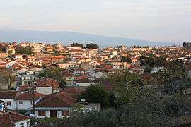
 General view of Nea Zichni with Pangaion Mountain behind.
 Nea Zichni countryside in Toumba location.
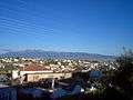
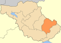 Nea Zichni municipality
External links
References
- 1 2 "Απογραφή Πληθυσμού - Κατοικιών 2011. ΜΟΝΙΜΟΣ Πληθυσμός" (in Greek). Hellenic Statistical Authority.
- ↑ Dimitrios C. Samsaris, Historical Geography of Eastern Macedonia during the Antiquity (in Greek), Thessaloniki 1976 (Society for Macedonian Studies), p. 134-135. ISBN 960-7265-16-5 & D. C. Samsaris, La vallée du Bas-Strymon á l’ époque impériale (Contribution épigraphique á la topographie, l’ onomastique, l’ histoire et aux cultes de la province romaine de Macédoine), Δωδώνη 18(1989),fasc. 1, σ. 282-283, n. 122-124 : The Packard Humanities Institute (Samsaris, Bas-Strymon 122, # PH150762) The Packard Humanities Institute (Samsaris, Bas-Strymon 122(1), # PH150763) The Packard Humanities Institute (Samsaris, Bas-Strymon 123, # PH150764)The Packard Humanities Institute (Samsaris, Bas-Strymon 124, # PH150765)
- ↑ Miltiades E. Bolaris: "Macedonian names and makeDONSKI pseudo-linguistics: The case of the name Pella"
- ↑ D. C. Samsaris, A History of Serres (in the Ancient and Roman Times) (in Greek), Thessaloniki 1999, p. 77-79
- ↑ http://muhacirin.blogcu.com/su-albumden-selanik-hatiralari-ekleyen-selanik-selanik-vilayet/7614320 Administrative Division of Selanik Province (Turkish)
- ↑ Kallikratis law Greece Ministry of Interior (in Greek)
- ↑ "Population & housing census 2001 (incl. area and average elevation)" (PDF) (in Greek). National Statistical Service of Greece.
Administrative division of the Central Macedonia Region | ||
|---|---|---|
| ||
| Regional unit of Chalkidiki |  | |
| Regional unit of Imathia | ||
| Regional unit of Kilkis | ||
| Regional unit of Pella | ||
| Regional unit of Pieria | ||
| Regional unit of Serres | ||
| Regional unit of Thessaloniki | ||
| ||