Litochoro
| Litochoro Λιτόχωρο | |
|---|---|
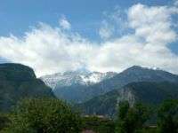
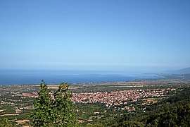 View from Olympus | |
 Litochoro Location within the regional unit 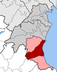 | |
| Coordinates: 40°6′N 22°30′E / 40.100°N 22.500°ECoordinates: 40°6′N 22°30′E / 40.100°N 22.500°E | |
| Country | Greece |
| Administrative region | Central Macedonia |
| Regional unit | Pieria |
| Municipality | Dio-Olympos |
| • Municipal unit | 169.632 km2 (65.495 sq mi) |
| Elevation | 293 m (961 ft) |
| Population (2011)[1] | |
| • Municipal unit | 7,259 |
| • Municipal unit density | 43/km2 (110/sq mi) |
| Time zone | UTC+2 (EET) |
| • Summer (DST) | UTC+3 (EEST) |
| Postal code | 602 00 |
| Area code(s) | 23520 |
| Vehicle registration | KN |
Litochoro (Greek: Λιτόχωρο, Litóchoro; Katharevousa: Λιτόχωρον) is a town and a former municipality in the southern part of the Pieria regional unit, Greece. Since the 2011 local government reform it has been part of the Dio-Olympos municipality, of which it is the seat and a municipal unit.[2] It is located at the base of Mount Olympus, on the western shore of the Thermaic Gulf. The first recorded mention of Litochoro is in an account of a visit by Saint Dionysius (Greek: Άγιος Διονύσιος) to Mount Olympus in the 16th century.[3] The town is a popular destination for those wishing to climb Mount Olympus as almost all climbing routes begin to the southwest of the town. A famous son of the town was Christos Kakkalos, who ascended first Mount Olympos in 1913.
Geography and information
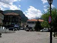
Litochoro is located 22 km S of Katerini, 90 km SSW of Thessaloniki, 58 km N of Larissa and 420 km WNW of Athens, on the eastern slopes of Mount Olympus, of mythological fame as the home of the twelve gods of Olympus. Two important ancient sites are located in the neighbourhood of Litochoro. Dion with its large archaeological park and a museum is located about 8 km to the north. Leivithra with its acropolis and the Leivithra Park is about 9 km to the south. The municipal unit has an area of 169.632 km2.[4] Pine, cedar and fir trees of the forests of Mount Olympus lie to the southwest and northwest. Much of the land around Litochoro, in particular to the South, remains uncultivated. Farmland is predominant to the North. Litochoro has several restaurants and cafeterias.
Facilities
.jpg)
Litochoro has schools, banks, a post office, a harbour, a sports centre, a town hall, a hospital, a museum, a concert hall, a gym, shopping facilities and squares. There are two main churches: Agios Nikolaos in the centre and Agios Dimitrios in the North. Litochoro has one of the most traditional cemeteries of Greece, known as Agios Athanasios, in the north of the town.
Places of Interest
Olympus National Park Information Center
Important information is provided here for visitors of Mount Olympus National Park. The Information Center informs their visitors about the geology, archaeological sites, mythology, monasteries, plants, animals and other subjects affecting Mount Olympus.
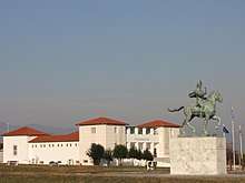
Located beside the highway (GR-1/E75), the Alexandreion is an impressive monument-building devoted to Alexander the Great. Visitors will get informed about his life and his military campaign.
At Agios Nikolaou 15, on the first floor, resides the Nautical Museum of Litochoro. Rather unknown, the village has a long maritime history to tell.
The old Monastery Agios Dionysios
At an altitude of 850 m, beside the Enipeas gorge, Saint Dionysios built a monastery. Founded 1542, its name was Agia Triada, what means Holy Trinity, later changed to the name of the Saint. Plundered and burned several times in its history, it received the final blow from German troops in April 1943.
The new Monastery Agios Dionysios
After the old monastery was destroyed, the monks moved to the Metochion three kilometers outside of the village and made the place their new monastery.
Settlements
Pláka
An extended coastal area known as Pláka or Pláka Litochorou (Πλάκα Λιτοχώρου) is located east of the town of Litochoro, spreading from the foot of Olympus to the Thermaic Gulf and extending from Leptokarya in the south to Gritsa in the north. The E75 highway passes through the area of Plaka to the south of Litochoro.[5] The coast mainly consists of sandy beaches with seaside resorts as well as hotels, campsites, restaurants, and beach bars (which mostly operate during the summer season from June to September). In the area of Plaka there are private residences, luxurious villas, and cottages.[6]
Gritsa
North-east of Litochoro (North from Pláka) the coastal area continues, known by the name Gritsa or Limenas Litochorou extending from Pláka in the south to the community of Variko in the north. Sandy beaches can be also found here but the tourist facilities are much less than Pláka's. Yet here are some cottages and a luxury hotel (Dion resort). Gritsa is also the port of Litochoro, even though its capacity is restricted.
Access and transport
Since the 1960s Litochoro has been served by an interchange with GR-1/E75 to its east. In the mid-1990s, parts of the Greek national road from Athens to Thessaloniki were upgraded to motorway standard. Litochoro is on the Northern stretch of this 6 lane dual carriageway, 90 km from Thessaloniki. Its nearest beach is 5 km to the east.
There is a regular bus service to Katerini and a local train service (3 trains daily in each direction) to Thessaloniki and Larissa, where there is an interchange with the main line to Athens. Because Litochoro railway station is about 6 km away from Litochoro and 1 km from the nearest bus stop, people wishing to take the train often take the bus to Katerini and take the train from there. Taxis are to be found in abundance.
- Litochoro acquired some fame during the 1999 NATO war in Yugoslavia when allied naval forces arrived on the beach of Gritsa; an action which provoked a reaction by the town's Communists and many people took part in it. The event was broadcast live on CNN International.
Historical population
| Year | Town population | Municipal unit |
|---|---|---|
| 1981 | 6,157 | - |
| 1991 | 6,667 | 6,864 |
| 2001 | 6,697 | 7,011 |
| 2011[1] | 6,995 | 7,259 |
See also
References
- 1 2 "Απογραφή Πληθυσμού - Κατοικιών 2011. ΜΟΝΙΜΟΣ Πληθυσμός" (in Greek). Hellenic Statistical Authority.
- ↑ Kallikratis law Greece Ministry of Interior (in Greek)
- ↑ "Dimos Diou olympou".
- ↑ "Population & housing census 2001 (incl. area and average elevation)" (PDF) (in Greek). National Statistical Service of Greece. Archived from the original (PDF) on 2015-09-21.
- ↑ "Plaka Litochoro". Pieriki Anaptyxiaki S.A. Retrieved 16 June 2011.
- ↑ "Plaka Litochoro". Villa Litochoro. Retrieved 16 June 2011.
External links
| Wikivoyage has a travel guide for Litochoro. |
| Wikimedia Commons has media related to Dimos Litohorou. |