Petra, Pieria
| Petra Πέτρα | |
|---|---|
 Petra Location within the regional unit 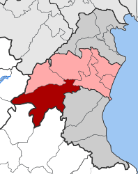 | |
| Coordinates: 40°15′N 22°21′E / 40.250°N 22.350°ECoordinates: 40°15′N 22°21′E / 40.250°N 22.350°E | |
| Country | Greece |
| Administrative region | Central Macedonia |
| Regional unit | Pieria |
| Municipality | Katerini |
| • Municipal unit | 219.318 km2 (84.679 sq mi) |
| Population (2011)[1] | |
| • Municipal unit | 4,888 |
| • Municipal unit density | 22/km2 (58/sq mi) |
| Time zone | UTC+2 (EET) |
| • Summer (DST) | UTC+3 (EEST) |
| Postal code | 60100 |
| Area code(s) | 23510 |
| Vehicle registration | KN |
Petra (Greek: Πέτρα) is a former municipality in Pieria regional unit, Greece. Since the 2011 local government reform it is part of the municipality Katerini, of which it is a municipal unit.[2] The municipal unit has an area of 219.318 km2.[3] The population was 4,888 in 2011.[1] The seat of the municipality was in Milia. Petra is also the name of a small settlement in the community Foteina, that had a population of 37 in 2011.[1]
References
- 1 2 3 "Απογραφή Πληθυσμού - Κατοικιών 2011. ΜΟΝΙΜΟΣ Πληθυσμός" (in Greek). Hellenic Statistical Authority.
- ↑ Kallikratis law Greece Ministry of Interior (in Greek)
- ↑ "Population & housing census 2001 (incl. area and average elevation)" (PDF) (in Greek). National Statistical Service of Greece.
Notes
- Travels in northern Greece By William Martin Leake page 337 ISBN 1-4021-6770-9
This article is issued from
Wikipedia.
The text is licensed under Creative Commons - Attribution - Sharealike.
Additional terms may apply for the media files.