Phayu District
| Phayu พยุห์ | |
|---|---|
| Amphoe | |
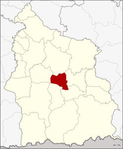 Amphoe location in Sisaket Province | |
| Coordinates: 14°54′12″N 104°23′30″E / 14.90333°N 104.39167°ECoordinates: 14°54′12″N 104°23′30″E / 14.90333°N 104.39167°E | |
| Country | Thailand |
| Province | Sisaket |
| Seat | Phayu |
| Area | |
| • Total | 225.485 km2 (87.060 sq mi) |
| Population (2005) | |
| • Total | 36,325 |
| • Density | 161.1/km2 (417/sq mi) |
| Time zone | ICT |
| Postal code | 33230 |
| Geocode | 3320 |
Phayu (Thai: พยุห์, pronounced [pʰā.júʔ]) is a district (amphoe) in the central part of Sisaket Province, northeastern Thailand.
History
The minor district (king amphoe) was created on 30 April 1994, when five tambons were split off from Mueang Sisaket.[1] On 11 October 1997 it was upgraded to a full district.[2]
Geography
Neighboring districts are (from the north clockwise) Mueang Sisaket, Nam Kliang, Si Rattana, Phrai Bueng, and Wang Hin.
Administration
The district is divided into five sub-districts (tambon), which are further subdivided into 65 villages (muban). Phayu is a township (thesaban tambon) which covers parts of the tambon Phayu. There are a further five tambon administrative organizations (TAO).
| No. | Name | Thai name | Villages | Pop. | |
|---|---|---|---|---|---|
| 1. | Phayu | พยุห์ | 12 | 9,002 | |
| 2. | Phrom Sawat | พรหมสวัสดิ์ | 20 | 9,457 | |
| 3. | Tamyae | ตำแย | 15 | 7,718 | |
| 4. | Non Phek | โนนเพ็ก | 11 | 6,109 | |
| 5. | Nong Kha | หนองค้า | 7 | 4,039 |
References
- ↑ ประกาศกระทรวงมหาดไทย เรื่อง แบ่งเขตท้องที่อำเภอเมืองศรีสะเกษ จังหวัดศรีสะเกษ ตั้งเป็นกิ่งอำเภอพยุห์ (PDF). Royal Gazette (in Thai). 111 (42 ง): 21. May 26, 1994.
- ↑ พระราชกฤษฎีกาตั้งอำเภอหนองปรือ อำเภอห้วยกระเจา อำเภอทรายทองวัฒนา อำเภอปางศิลาทอง อำเภอเนินสง่า อำเภอนาทม อำเภอพระพรหม อำเภอแม่วงก์ อำเภอสองแคว อำเภอบ้านใหม่ไชยพจน์ อำเภอไทยเจริญ อำเภอกาบัง อำเภอพยุห์ อำเภอเมืองจันทร์ อำเภอภูพาน อำเภอคลองหอยโข่ง อำเภอเขาฉกรรจ์ อำเภอนาวัง อำเภอพิบูลย์รักษ์ และอำเภอทุ่งศรีอุดม พ.ศ. ๒๕๔๐ (PDF). Royal Gazette (in Thai). 114 (50 ก): 24–27. September 26, 1997.
External links
This article is issued from
Wikipedia.
The text is licensed under Creative Commons - Attribution - Sharealike.
Additional terms may apply for the media files.